California coastal waters are characterized as mixed semi-diurnal tides: two different high and two different low tides per day. The highest high tides within a calendar year are typically referred to as king tides, or, in a more scientific context, as perigean spring tides. King tides are a predictable, natural phenomenon, and this phrase generally refers to the peak winter high tides, since above average tides at this time of year are the most likely to produce the high tidal surge. King tide conditions are also generally associated with the lowest tides of the year.
“Normal” spring tides usually occur twice each month and refer to the ‘springing forth’ of the tide during the new moon and full moon. Spring tides are caused by the near alignment of the Earth, sun, and moon, allowing the gravitational pull of the sun on Earth to be “added” to the gravitational pull of the moon on Earth, causing the oceans to bulge a bit more than usual. NOAA’s National Ocean Service has a helpful visualization of spring tides that can be seen by clicking here.
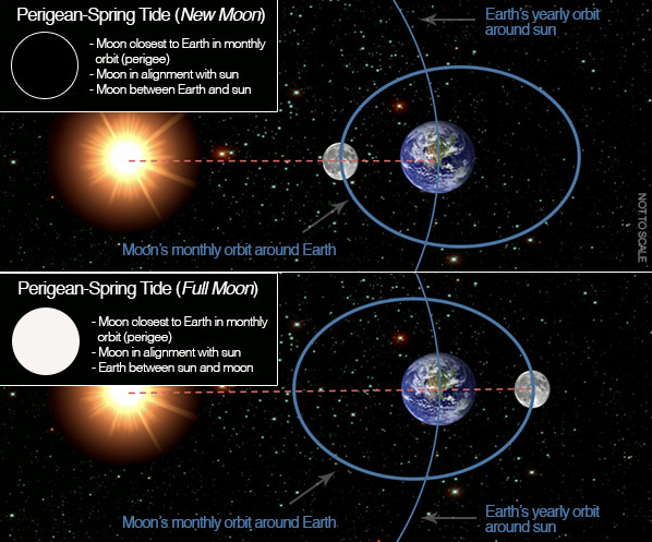
When spring tide conditions occur at the same time that the moon is at its perigee (closest to Earth) in its monthly orbit, tidal ranges are slightly increased, and these tides are called perigean spring tides (Figure 1). In the northern hemisphere winter, usually in early January, the Earth is also closest to the sun (perihelion), further contributing to increased tidal ranges. The term “king tide” first came to be used to describe the highest tides of the year in Australia, New Zealand, and islands of the South Pacific, and has now been widely adopted in North America. King tide conditions usually persist for three or four days, when the earth, moon, and sun are closest to being in alignment. While mild tidal flooding in low-lying coastal areas is more common during king tides, the presence of storm surges (i.e. storm-induced water movement) or other rough ocean conditions can increase the height of a king tide and lead to more severe flooding events.

Although the occurrence of king tides is not a result of rising sea levels associated with global climate change, climate and weather do influence coastal sea levels through storm surges, as do ENSO (El Niño Southern Oscillation) and PDO (Pacific Decadal Oscillation) cycles. As sea level rises, the height of tidal systems will also rise, and extreme high tides will extend further inland than in the past. King tides and associated coastal flooding and erosion are particularly useful for envisioning the elevated sea levels that are expected in many regions in the future. For this reason, king tides have become the focus of international photo initiatives that encourage local citizens to document the events and share images on social media platforms. In addition to engaging the public in citizen science, these collections of real, unmanipulated photographs serve as compelling, often dramatic, visualizations that can educate the public about the potential impacts of climate change. Such photo libraries of “preview” conditions can also be useful in identifying flood-prone locations, designing policy changes, and creating local adaptation strategies.
The first major photographic initiative to capture king tide impacts took place in 2009 in New South Wales, Australia, and led to the publication of a report titled ‘A Snapshot of Future Sea Levels: Photographing the King Tide.’ In California, the California King Tides citizen science initiative has been developing a library of king tide photos along the California coast since the 2010-11 winter. Since 2010, nearly 500 photos of king tide events from many California coastal communities, including Monterey Bay (Figures 2-3), have been posted to the site. Organizing partners for the California King Tides initiative include the California Coastal Commission, California Coastkeeper Alliance, Gulf of the Farallones National Marine Sanctuary, San Francisco Bay National Estuarine Research Reserve, Thank You Ocean, and the Tijuana River National Estuarine Research Reserve. Other king tide photo projects using citizen scientists have been organized in Oregon, Washington, and British Columbia. Photographs of king tides often depict low-lying shoreline development that is likely to be at increased risk of flooding under future conditions of elevated sea levels. It is possible that the high water levels now reached only during king tides will become the water levels reached at high tide on an average day, and monitoring of king tides allows us to anticipate future changes and implement appropriate responses.


Links to More Information
- The website for the king tide photo initiative in California
- A video produced by Thank You Ocean on the California King Tides initiative
- Other king tide photo initiatives in Washington, Oregon, British Columbia, and Australia
- U.S. EPA Factsheet on king tides
- National Ocean Service explanation of spring tides
- National Ocean Service explanation of perigean spring tides
- A December 11, 2012 San Jose Mercury News article on the December 2012 king tide event
- A December 12, 2012 San Luis Obispo Tribune article on king tides