 FACTS & TRENDS
- The study area encompassed the Monterey Bay, Cordell Bank and Gulf of the Farallones national marine sanctuaries.
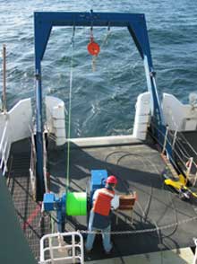
- The McArthur II is a 224-ft. NOAA research vessel.
- Close to 300 miles of seafloor were mapped using side scan sonar during the study.
National Oceanic and Atmospheric Administration (NOAA) and U.S. Geological Survey (USGS) scientists recently returned from a 21-day research mission with some of the most expansive seafloor documentation ever recorded of the Monterey Bay (MBNMS), Cordell Bank (CBNMS) and Gulf of the Farallones (GFNMS) national marine sanctuaries. The platform for the cruise was the 224-ft. NOAA ship McArthur II.
This was a collaborative venture involving the MBNMS;
CBNMS; GFNMS; USGS; National Marine Fisheries Service (NMFS), Santa Cruz Laboratory; Northwest Fisheries Science Center, Newport, OR; Washington State University Vancouver, Vancouver, WA; NOAA Marine Protected Areas Center’s Science Institute (MPA); and Deep Ocean Engineering (DOE).
Researchers mapped the seafloor with side-scan sonar and captured video showing the diversity of sea life, health of habitat and characteristics of the seafloor, including a first look at many areas. The cruise consisted of 3 different legs:
Cordell Bank Survey (1-7 April); Fanny Shoal and Shelf Survey in GFNMS (7-14 April); and Continental Shelf Survey in the MBNMS (14-22 April).
Results of the research from the 2004 McArthur II seafloor mapping cruise of the sanctuaries will provide valuable characterization of sanctuary biology and geology that is useful as a foundation for management of the national marine sanctuaries.
Mapping, describing and visualizing seafloor habitats and their biodiversity within the sanctuaries will help managers to protect important habitats, plants, and animals. The knowledge of what is present today will also provide the foundation to monitor changes in these important resources.
Downloads
Study Area Map (140 Kb JPG file)
Quicktime Video (High resolution, 11.6 Mb MOV file)
Quicktime Video (Low resolution, 3.6 Mb MOV file)
Preliminary Species List (20 Kb XLS file)
Cruise Fact Sheet (40 Kb DOC file)
Goal of mission:
To acoustically image, document and film extensive seafloor habitats and life on the seafloor within the MBNMS, CBNMS, and GFNMS as part of a multi-agency seafloor mapping project.
Objectives:
- To map the seafloor in three West Coast national marine sanctuaries: MBNMS, CBNMS, and GFNMS.
- To groundtruth habitat maps in two West Coast national marine sanctuaries using a camera sled (MBNMS and CBNMS).
- To characterize habitats and associated benthic macroinvertebrates and fish assemblages in two West Coast national marine sanctuaries using a camera sled (MBNMS and CBNMS).
- To make mapping information available to the public.
Technology and equipment used:
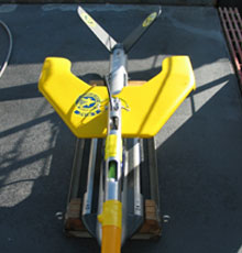
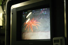
The small (60 kg) video-sled (1.3 m long x 0.4 m wide x 0.5 m high) was towed underwater behind the NOAA research vessel McArthur II to film and document habitats and life on the seafloor of the MBNMS, CBNMS and GFNMS. Scientists used a Klein 3000 side-scan sonar system to acoustically image several previously unmapped sections of the seafloor within these sanctuaries. During the cruise (April 1 to April 21) teams of scientists worked day and night to collect information on the seafloor using towed video and side-scan sonar. Seafloor descriptions were recorded by the scientists every 30 seconds during real-time observations of the seafloor, providing a wealth of information about habitats and life on the seafloor.
Key findings or results:
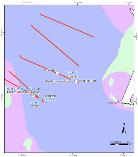
A variety of seafloor types were identified within the sanctuaries:
- Sand-wave habitats were occupied by sanddabs and often contained schools of baby rockfish.
- Sediment-ripple habitats were commonly occupied by white brittle stars buried within the sediment.
- Low-lying cobble beds were occupied by encrusting sponges, gorgonians, and half-banded rockfishes.
- High relief bedrock habitats, although less common on the mid to outer shelf, were occupied by encrusting invertebrates, vase sponges, large anemones, gorgonians, and many species of rockfishes.
While the ability to record seafloor descriptions in real time at sea requires a team of dedicated researchers, this approach dramatically improves the speed at which seafloor information can be made available to managers, stakeholders, and the public. Importantly, this novel approach also enables web-users to examine the nature of the seafloor at locations of interest with the capability of viewing footage from these areas within weeks of completion of the survey.
In addition, close to 300 miles of the seafloor were mapped at Cordell Bank, Fanny Shoal (GFNMS) and off Pescadero Point (MBNMS) using side-scan sonar.
Principal investigators include Jean de Marignac (MBNMS), Erica Burton (MBNMS), Dr. Tara Anderson (USGS & NMFS Santa Cruz), Dr. Roberto Anima (USGS Menlo Park), Dale Roberts (CBNMS), John Chin (USGS Menlo Park), and Dr. Andrew DeVogelaere (MBNMS).
This project demonstrates the quantity and quality of work accomplished between government agencies to conduct needed investigative work to ascertain what resources we have in our sanctuaries. The cooperating agencies pulled together sea-floor mapping tools and video-camera expertise to conduct both habitat mapping and biodiversity mapping.
More information:
- Monterey Bay National Marine Sanctuary – http://montereybay.noaa.gov
- Cordell Bank National Marine Sanctuary – http://cordellbank.noaa.gov
- Gulf of the Farallones National Marine Sanctuary – http://farallones.noaa.gov
- National Marine Fisheries Services – http://swfsc.noaa.gov/default1.aspx?Division=FED&id=554
- McArthur website – http://www.moc.noaa.gov/mt/index.html
- U.S. Geological Survey ‘Continental Shelf GIS for the Monterey Bay National Marine Sanctuary’ – http://geopubs.wr.usgs.gov/open-file/of01-179
- U.S. Geological Survey Coastal & Marine Geology InfoBank field activity metadata – http://walrus.wr.usgs.gov/infobank/m/m104nc/html/m-1-04-nc.meta.html
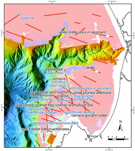
Preliminary Video and Image Data
The clickable maps below show seafloor sediment composition, camera sled tracklines, and image and video locations from the McArthur II cruise. For each location, click the blue titles to view images and click the black titles to view short video clips. Note: these are preliminary findings from the cruise and only represent a small portion of the total area surveyed. Viewing these video files requires the Quicktime media player.
Cordell Bank Area
 Monterey Bay Area