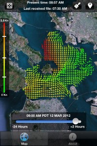
Navigating San Francisco Bay just became a little easier. The free Bay Currents app uses Google maps, GPS technology and shore-based radar sensors that collect real-time information about surface currents. The application, which works on your iPhone, iPod touch and iPad, shows surface current speed and direction in an area bordered by the Golden Gate Bridge, San Francisco-Oakland Bay Bridge and Richmond Bridge.
Data on surface currents are updated every 30 minutes, along with a projection for the next two hours. Users can also obtain information from the previous 24 hours. The Bay Currents app is one component of the development of a state-wide radar network for real-time mapping of currents along the entire California coast. The app was developed by researchers at San Francisco State’s Romberg Tiburon Center, along with six other universities, and received funding through two state water bond measures passed by voters in 2002.