Elkhorn Slough contains the majority of Monterey Bay National Marine Sanctuary’s estuarine habitat, supporting hundreds of species of wildlife and providing additional benefits like water filtration and carbon storage. However, human activities like wetland conversion for agriculture have resulted in loss of over 50% of marsh area in Elkhorn Slough. Most marshes (except the recent restoration site) are expected to disappear within the next century due to sea-level rise. The new restoration site, named Hester Marsh, covers 61 acres and involved 200,000 cubic yards of sediment addition to restore an elevation suitable for marsh plants and resilient to projected sea-level rise. Elkhorn Slough National Estuarine Research Reserve’s (ESNERR’s) Tidal Wetland Program undertook this project with involvement from sanctuary staff and other stakeholders, managers, and researchers. After years of planning, fundraising, and overcoming regulatory hurdles, this project has moved forward so that Elkhorn Slough will still have marshes, and the many benefits they provide, for future generations to enjoy.
In August 2018, construction at the Hester Marsh restoration site was completed and the tides were allowed to enter the new channels. Monitoring is underway to ensure that this project can serve as a model for future restorations in Elkhorn Slough and along the California coast, as over 90% of the state’s wetlands have been lost, primarily due to human activities. See Hester Marsh video summary for more information.
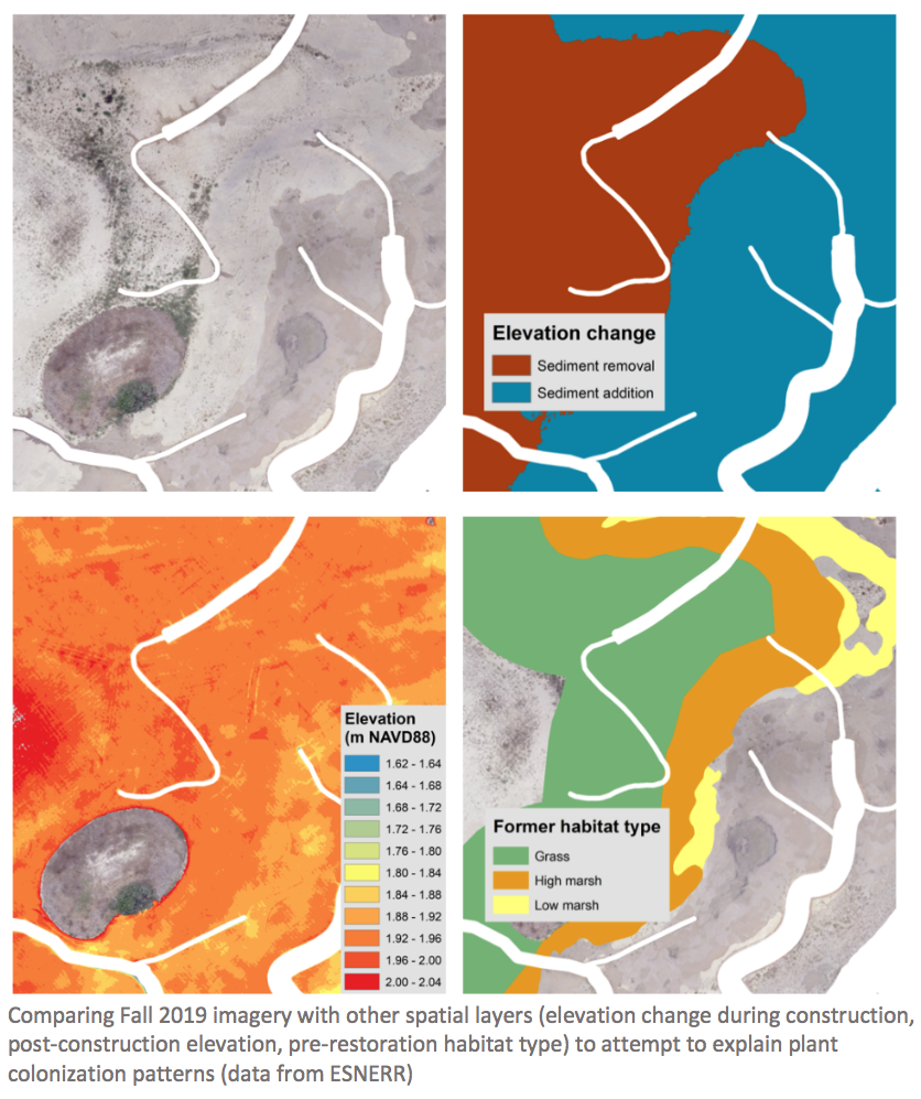
The Elkhorn Slough NERR and partners are undertaking a variety of monitoring activities, including tracking elevation change, wildlife use, natural plant colonization, and effectiveness of different planting strategies. Unmanned aerial vehicle (UAV, or “drone”) technology has already proven valuable in many aspects of monitoring. Alexandra Thomsen, a NOAA Center for Coastal and Marine Ecosystems graduate student at CSU Monterey Bay and sanctuary intern, is examining the use of UAV data for understanding the drivers of natural plant colonization to inform future restoration efforts in collaboration with ESNERR.
Before conducting this analysis, however, optimal methods for data collection and image analysis needed to be worked out. The flight elevation, spectral range of data (visible only, or visible + near infrared), and image classification technique can affect what size plants can be detected in imagery, how accurate percent cover assessment is, and whether plant species can be distinguished from each other.
Alex Thomsen and ESNERR research staff (John Haskins, Charlie Endris, and Alex Lapides) tested four different UAV flights over a section of the marsh. These flights resulted in six usable datasets for comparison: 10 m flight elevation RGB (red/green/blue, visible spectrum) imagery, 30 m RGB imagery, 30 m RGB + NIR (near infrared) imagery, 60 m RGB imagery, 60 m RGB + NIR imagery, and 30 m higher resolution RGB imagery (48 megapixel (MP), compared with 20 MP for the other flights).
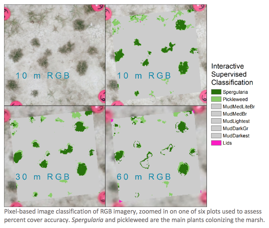
Experimentation with unsupervised and supervised classification techniques in ArcGIS software and comparisons between the datasets indicated that 30 m RGB + NIR imagery would be optimal as a compromise between flight time and accuracy. Of 60 individual plants examined, 95% were visible in this imagery and 55% were identifiable as plants (as opposed to visible but unidentifiable objects). Both the 10 m and 30 m higher resolution imagery were slightly better for visually detecting plants, but would be unrealistic to use for the whole site due to time and battery life constraints. Image classification of the 30 m RGB + NIR imagery was best overall in assessing percent cover when correlated with field-measured percent vegetation cover (R = 0.92, slope = 0.97). However, species could not reliably be distinguished from each other by the image classification techniques used. This UAV method was recently used to create a new dataset covering the whole Hester Marsh area, which will be used for future analysis on the drivers of plant colonization patterns.
To learn more about the Hester Marsh restoration, visit: https://www.elkhornslough.org/tidal-wetland-program/hester-marsh-restoration/