Written by Lisa Uttal, Monterey Bay National Marine Sanctuary
Monterey Bay National Marine Sanctuary encompasses over 6,000 square miles of protected waters. It is a place of wonder, home to kelp forests, deep-sea canyons and a staggering array of marine life. But how do we track the health of such a vast, dynamic environment? And how can managers, residents and visitors alike keep their finger on the pulse of the sanctuary?
An answer has arrived with the launch of the new Sanctuary Watch web portal, a digital gateway designed to bring the sanctuary’s complex monitoring data directly to sanctuary managers and the public.
“We are incredibly fortunate to live adjacent to such a vibrant, ecologically rich system,” said Andrew Devogelaere, Monterey Bay National Marine Sanctuary research ecologist. “A primary goal of NOAA’s Office of National Marine Sanctuaries is to pay attention to their health and see if there are things we can do to protect them. With Sanctuary Watch, we’re essentially opening up research and science to the community. We want people to understand how the sanctuary is functioning and how it’s changing over time and space.”
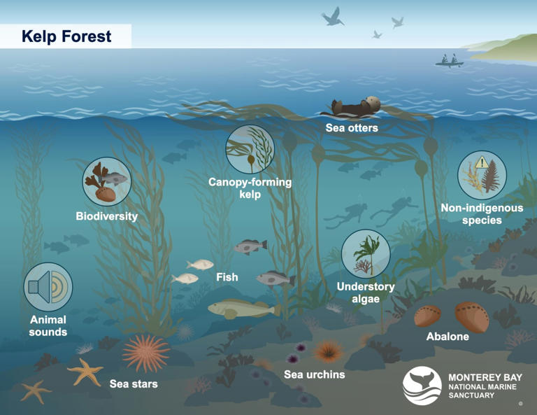
The heart of the new website is the sanctuary Condition Tracking tool, an interactive platform that transforms dense scientific data into accessible and visual information. The sanctuary encompasses diverse habitats like the estuary, rocky shore, kelp forest, deep sea and open ocean.
“The idea was to make key information we use to track sanctuary health available not just to sanctuary managers, but to the public as well,” Sanctuary Watch program lead Jennifer Brown, Ph.D., explained. “In each of these habitats, there are clickable icons representing the species and conditions of most interest in the sanctuary. These icons link to windows showing data and information that tells us how the sanctuary changes over time. We are also telling the story of how our understanding of the sanctuary can evolve and improve.”
Take, for instance, the kelp forest — a habitat that has dominated local headlines. The tool allows users to track species in kelp forests that have faced significant population challenges along the West Coast. Users can explore up-to-date monitoring data from groups like the Partnership for Interdisciplinary Studies of Coastal Oceans at UC Santa Cruz, viewing trends of kelp forest organisms such as purple sea urchins and giant kelp.
The tool highlights critical ecosystem changes, such as the population status of the sunflower sea star. DeVogelaere emphasizes the tool’s utility in connecting monitoring efforts to real-world outcomes: “The tracking tool provides access to more than just numbers on a page,” he said. “It provides context, offering links to photos, videos and deeper stories about the current issues facing this species. It connects the data to the reality of managing the kelp forest ecosystem.”
The website also dives into the mysteries of the open ocean. Monterey Bay is a world-class destination for whales and the people who study them. The open ocean scenes of the new tool take you beyond what can be seen from seasonal whale-watching tours. It provides a window into the acoustic life of the sanctuary. By integrating data from Monterey Accelerated Research System’s underwater listening station, the tool reveals when blue and fin whale songs are detected, showing distinct seasonal patterns that might otherwise remain hidden beneath the waves.
If you’ve ever wondered if the whales are here right now or what the sanctuary sounds like at night, this tool can answer that. It provides access to the Monterey Bay Aquarium Research Institute’s whale sound recordings, sanctuary sound monitoring reports and even the live soundscape listening room. It makes the invisible visible.
Perhaps most timely is the inclusion of ocean condition tracking. As the region anticipates changes driven by the forecasted El Niño, the tool provides weekly updates on whether recent sea surface temperatures in the sanctuary are typical or reaching marine heatwave status. These maps and graphs are updated in coordination with the California Current Marine Heatwave Tracker created by the NOAA Southwest Fisheries Science Center.
“The sanctuary is surrounded by over 50 research institutions, each collecting essential data on different components of the sanctuary,” said Brown. “We are working to compile those different components to give us a more complete and evolving picture of sanctuary conditions. This is a living resource. Some data, like satellite monitoring, is near-real time, while others — like scuba surveys in kelp forests — might update annually. I invite everyone to check back regularly to see what new tracking information we’ve added.”
The launch of the Sanctuary Watch platform is an invitation for engagement. By demystifying the science behind sanctuary management, the team hopes to foster a deeper connection between the public and the waters they protect.
“The Monterey Bay Condition Tracking tool is here to help us better understand how the sanctuary is functioning,” said Brown. “When we understand it, we can better manage it. We want the public to continue to get into their sanctuary and enjoy it for years to come.”
Do you want to know about the health of your sanctuary? To explore, visit the new Sanctuary Watch website at sanctuarywatch.ioos.us. Many scientists and partners are monitoring different aspects of the sanctuary and together, helping us better understand the condition of Monterey Bay National Marine Sanctuary.
Lisa Uttal is science outreach and media coordinator at Monterey Bay National Marine Sanctuary.
This article can be found online at the Santa Cruz Sentinel.