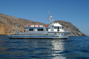
- The Shearwater is a brand new 62 foot aluminum catamaran that serves as a research platform for a variety of projects in the Channel Islands and Monterey Bay National Marine Sanctuaries.
- Research divers developed species lists at 9 subtidal sites and estimated the abundance of sealife at 6 subtidal sites that were near natural landslides.
- In spring 2004, the Shearwater will return to the Sanctuary to assist in further sampling. This information is needed for a Big Sur Coastal Highway Management Plan.
The Monterey Bay National Marine Sanctuary and the California Coastal Commission are working closely with the California Department of Transportation (CalTrans) and several other local, state, and federal agencies to develop a Corridor Management Plan along the Big Sur Coast. Highway 1 in Big Sur is often subject to delays and closures due to storms, washouts, and landslides. The purpose of the Big Sur Coast Highway Management Plan (CHMP) is to develop sustainable strategies that ensure the safe and efficient operation of the highway while protecting the unique qualities and sensitive terrestrial and marine resources of this remarkable coastline.

From September 12-26, 2003 the R/V Shearwater was in the Monterey Bay National Marine Sanctuary to assist with the biological characterization of the Big Sur coast. Based in the Channel Islands National Marine Sanctuary,
the Shearwater is a brand new 62 foot aluminum catamaran that serves as a research platform for a variety of projects in the Channel Islands. Twice each year it is scheduled to visit the Monterey Bay National Marine Sanctuary to conduct research. During its first visit to the Sanctuary, the Shearwater cruised up and down the central coast from Monterey down to Ragged Point, transporting research divers to some of the most spectacular and remote diving sites within the Sanctuary.

As one part of the CHMP, the biological characterization project was designed to survey intertidal and nearshore subtidal areas along the Big Sur coast. The surveys focused on areas of coastline known or with the greatest potential to be affected by highway repairs from landslides or other storm-related events. Data collected included species lists, population densities, and presence of economically important, particularly sensitive and/or endangered species. The results will be placed into multiple GIS-data layers and maps for resource managers and the public. In particular, data were collected to:
- Characterize geological substrate types at selected sites as granite, boulder, sand, etc.
- Identify physical factors at these sites which may affect the sensitivity of marine biota to disposal activities, such as wave energy, and qualitatively rank each site by physical exposure categories which could affect disposed material.
- Characterize biological assemblages at these sites. Identify and note the abundance of those species that may be particularly susceptible to disposal activities, such as the sea palm and owl limpet.
- Rank critical and/or disposal-sensitive habitats using indices such as location, size, and quality in order of most critical to least critical; consider species assemblages’ degree of tolerance to sediment disposal (i.e., burial, scour, turbidity) and physical factors.

In collaboration with researchers from the Partnership for Interdisciplinary Studies of Coastal Oceans (PISCO) at UC Santa Cruz, Sanctuary research divers inventoried 9 subtidal sites and quantitatively sampled 6 subtidal sites that were near natural landslides. In addition, PISCO and Sanctuary researchers sampled five more subtidal sites (Andrew Molera, Esalen, Big Creek, Lopez Point, and Plaskett Rock). Intertidal surveys at six sites (adjacent to subtidal sites already sampled) will be completed during low tides in November or December 2003. In spring 2004, the Shearwater will return to the Monterey Bay National Marine Sanctuary and allow researchers to sample these same six sites to assess seasonal differences.
