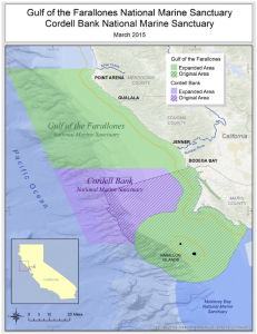
North of the busy streets of San Francisco, across the Golden Gate and beyond the Marin Headlands and Bodega Bay, California’s coastline grows wilder and more sparsely populated by the mile. Waves crash against dramatic cliffs carved by eons of pounding surf, interrupted by hidden coves sheltering narrow slivers of sand that see few human visitors. Offshore, an engine of life churns beneath the water’s surface, driving one of the most productive ocean ecosystems on the planet.
Now, after more than a decade of community action, scientific research, political effort and public debate, NOAA has announced the expansion of Gulf of the Farallones and Cordell Bank national marine sanctuaries to more than twice their original size, extending their boundaries to encompass this ruggedly beautiful—and ecologically critical—stretch of California’s coastal and ocean waters.
Gulf of the Farallones National Marine Sanctuary, which encompasses an area to the north and west of San Francisco Bay, will increase in size from 1,282 square miles to 3,295 square miles. The expansion moves its northern boundary roughly 62 miles further up the coast, from Bodega Bay to Point Arena. The neighboring Cordell Bank National Marine Sanctuary will also see its borders expand from 529 square miles to 1,286, reaching further into the offshore waters of Marin County to include Bodega Canyon.
The expansion will increase protection of the marine resources and coastal habitats that lie within the 2,770 square miles of newly incorporated waters, such as areas of major upwelling where nutrients come to the surface and support a vast array of sea life including 25 endangered or threatened species, 36 marine mammal species, over a quarter million breeding seabirds, and one of the most significant great white shark populations on the planet. Point Arena in particular has been a focus for NOAA scientists, as it is the location of one of the most productive upwelling zones in North America, making it a fundamental component of the Pacific marine ecosystem.
The success of this expansion effort is the latest in a series of recent milestones for NOAA’s Office of National Marine Sanctuaries. Summer 2014 started off with a bang as NOAA announced the update and reopening of the Sanctuary Nomination Process, granting the public the power to nominate marine and Great Lakes areas for potential consideration to become national marine sanctuaries. Thunder Bay National Marine Sanctuary celebrated its own expansion to 10 times its original size in September, extending federal protection to an estimated 100 additional shipwrecks in Lake Huron.
Out of the 14 sites in the National Marine Sanctuary System, four have now seen growth since their original designation. With more than 170,000 square miles of protected waters now managed by the sanctuary system, NOAA’s Office of National Marine Sanctuaries remains committed to working with communities to expand and strengthen our nation’s stewardship of our marine environment for future generations.
By Katherine Teshima (original article and video here)