This report summarizes efforts to assess the condition of the Monterey Accelerated Research System (MARS) cable and its potential effects on surficial sediments and biological communities, based on an initial biological assessment in 2004, Post-Lay Inspection and Burial Survey (PLIB) in 2007, and comprehensive surveys performed in 2008, 2010, 2015 and 2020. The most recent study was conducted 13 years after the cable was installed.
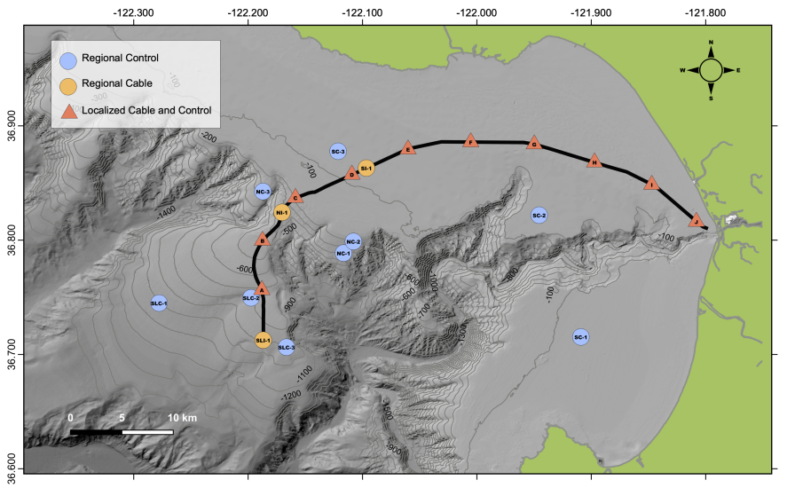
study stations. Colored circles represent regional stations for megafaunal and macrofaunal
impact studies at Shelf, Neck, and Slope regions. Blue = control, light orange = cable. Lettered
triangles (A−J) indicate transect stations for localized megafaunal studies on the cable route,
paired with transects 50 m away from the cable. The MARS instrument node (station SLI-1) is
on the seafloor at 891 m depth about 45.5 km from Moss Landing, in central California.
The sampling program was designed to: 1) observe the condition of the cable and cable path along the 60 km cable route, and 2) assess the potential impacts of the MARS cable on surficial geological conditions and benthic biological assemblages on a local scale (0–50 m from the cable) and at a regional scale (km),
based on video transects and sediment samples.
The MARS includes a 60 km-long undersea cable spanning from the Monterey Bay Aquarium Research Institute (MBARI) in Moss Landing, California to a science node at a depth of 891 m on the continental slope. The node is 45.5 km offshore, just outside of Monterey Bay, California. The system provides power and high data bandwidth for science instruments connected to the node via thin auxiliary cables deployed on the seabed by remotely operated vehicles (ROVs). MARS is one of a now growing number of cabled ocean-observing systems that enable continuous, long-term science capabilities for ocean science with real-time
communication, control, and data capture from offshore subsea sensor systems (Howe et al., 2019;
Martin Taylor, 2008; Suyehiro et al., 2003; Trowbridge et al., 2019).
The main MARS cable was installed in March 2007 from the cable-laying ship Global Sentinel. The cable was installed beneath the seabed for most of its length. Horizontal directional drilling (HDD) was used to install a steel 13 cm diameter pipe conduit from above the shoreline to 19 m water depth offshore (Barry et al., 2007). From this point, the cable was plowed into the seabed sediment to a depth of one meter for most of its length, and jetted into the sediment near the science node at the MARS site. Complete burial was not possible in the rocky seabed (authigenic carbonate crusts and rocky outcrops) at depths of 116–453 m below the continental shelf break.
The MARS science node was installed and powered briefly in February 2008, but failed due to a subsea connector. The failed parts were recovered, repaired, and reinstalled in November 2008. MARS has been fully operational since that time.