Overview
The continental shelf is the gradually sloping submerged margin of the continent that extends from the nearshore to the shelf break. Beyond the break (at a depth of approximately 200 meters, or 650 feet), the continental slope descends more steeply to the ocean floor. It can be subdivided according to depth, including:
- the intertidal (salt spray to extreme low water)
- shallow subtidal (0 to 30 meters)
- outer shelf (30 to 200 meters)
The boundaries of Cordell Bank National Marine Sanctuary include only the outer continental shelf, with shelf depths of approximately 70 to 80 meters along the eastern, nearshore boundary. Landward of the sanctuary are shelf areas shallower than 30 meters that are contained with the Greater Farallones National Marine Sanctuary.
The outer continental shelf is relatively broad throughout the extent of the Cordell Bank sanctuary, with the shelf break (western boundary of the shelf) located approximately 35 to 50 kilometers from shore. The continental shelf encompasses the prominent feature of Cordell Bank, with the shelf break wrapping from the west side of the bank around the north and east sides. Thus, on the western edge of the continental shelf, water depth changes dramatically from as deep as 200 meters to 35 meters at the shallowest pinnacles of the bank.
A large portion of the shelf in the sanctuary is composed of soft-bottom habitats, which cover approximately 822 square kilometers, from depths of 70 to 200 meters. Soft-bottom habitats are made up of sand and silt. In this sanctuary, most of the soft-bottom areas of the outer continental shelf are silt. Nevertheless, sand substrates are found in the region east of Cordell Bank, with the occurrence of sand increasing with increasing proximity to the bank.
The continental slope makes up 190 square miles of the sanctuary (35% of the sanctuary seafloor) and extends from about 200 m down to about 2,200 m at the western boundary of the sanctuary. The slope environment is primarily mud bottom with some rock habitats.
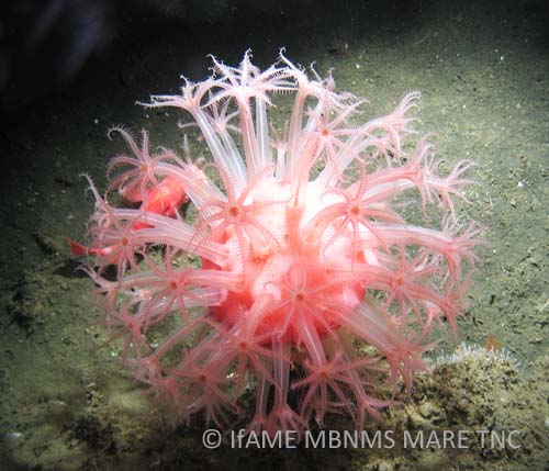
The lack of hard substratum for attachment prevents algae and some invertebrates from colonizing soft-bottom habitats. Soft-bottom associated species live either on the surface of, or buried in, the sediments. Some of these animals, such as the burrowing tube anemone, build somewhat permanent tubes and burrows. The burrowing and feeding activities of fishes and invertebrates (known as bioturbation) help to mix the surface sediments and also add some structural relief to a relatively flat habitat.
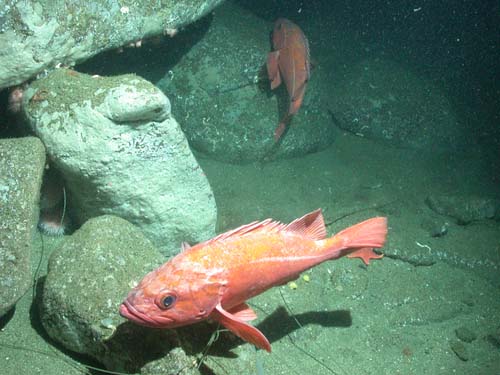
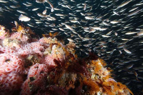
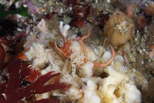
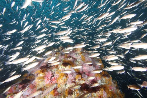
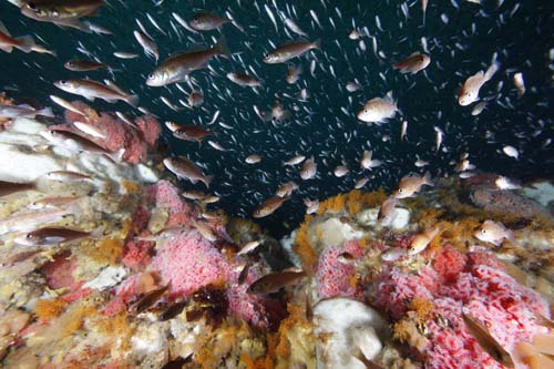
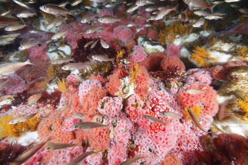
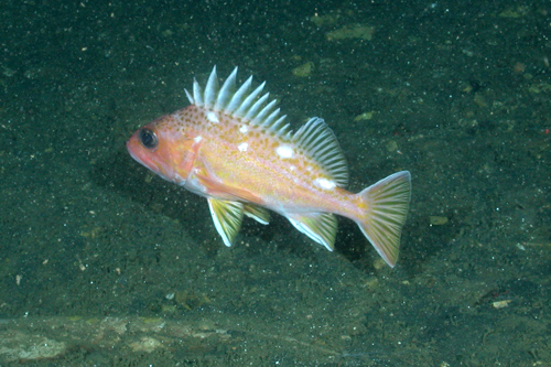
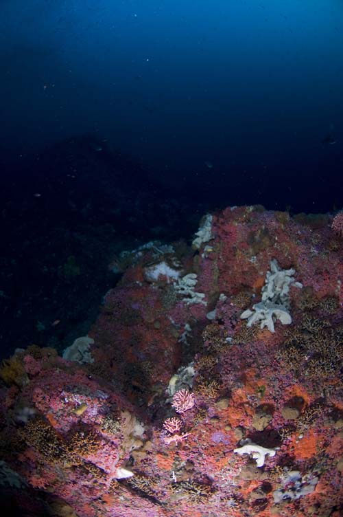
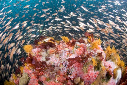
The complex physical structure created by rocky, hard-bottom areas within the outer continental shelf region provides habitats for a very different suite of organisms than those found in soft-bottom areas, including rockfishes, deep-water corals, sponges and anemones. This abundance of benthic life associated with hard substrates attracts pelagic predators, including seabirds and marine mammals, which hunt for fishes and invertebrate prey along the bottom and in the waters above the seafloor.
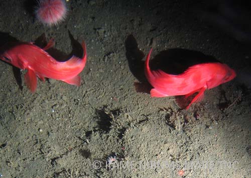
Within the sanctuary, Cordell Bank is a prominent hard-bottom feature, measuring approximately 7 x 14.5 kilometers. The bank makes up a large part of the outer continental shelf within the sanctuary and plays an important role in the marine ecosystem in this region. See the section on “Seamounts and Banks” for further information on this unique and productive environment.
Much less is known about the continental shelf than is known about coastal kelp forests and the sandy floor (0 to 30 meters), because the shelf is more difficult to sample than inshore areas. Sampling difficulties arise because the shelf is farther from shore and deeper and it experiences rougher seas. Remotely operated vehicles (ROVs), towed camera sleds and manned submersibles are often used to investigate the habitats and communities of the outer continental shelf.
Conservation and management issues with the potential to affect sanctuary resources on the shelf include seabed disturbance (e.g., trawl disturbance), marine debris, non-sustainable fishing, accumulation of
contaminants in the sediment and food web, and the laying of submerged cables. In order to make decisions about these and other potential issues, scientists need more information, such as a characterization of the sanctuary ecosystem, data on baseline conditions of the benthic community for future damage assessment, and knowledge of cultural resources and potential sunken polluters.
Bottom trawling relates to several of these issues: it can have negative impacts on benthic habitats, such as modification of the substratum, disturbance of soft-bottom communities, depletion of fishery resources (including non-target fish species) and potential animal entanglement. In fact, the structure of entire seafloor communities is at risk from this fishery practice. Currently, there is an incomplete picture about the extent of trawling’s impacts in the sanctuary, but the use of trawl gear is an ongoing concern.
Monitoring
Seafloor Mapping in Monterey Bay, Cordell Bank and Greater Farallones National Marine Sanctuaries
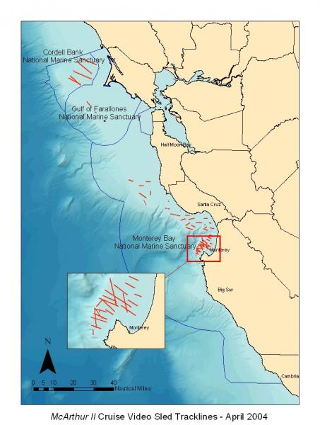
In April 2004, scientists from the National Oceanic and Atmospheric Administration (NOAA) and the U.S. Geological Survey conducted a 21-day research cruise aboard the NOAA Ship McArthur II. This study greatly contributed to our knowledge of the continental shelf in the three central California national marine sanctuaries. During this study, researchers mapped approximately 140 kilometers of the seafloor within Cordell Bank National Marine Sanctuary with side scan sonar. They collected underwater video with a towed camera sled to characterize the habitat types and diversity and the benthic assemblages of sea life on the continental shelf, including a first look at many areas.
Habitat characteristics such as slope, habitat complexity, depth and substrate type are being used to describe the physical habitats that make up the outer continental shelf and to relate these seafloor features to benthic community patterns. Results from this seafloor mapping study provide valuable characterization of sanctuary biology and geology that is useful as a foundation for management of the national marine sanctuaries.
Further mapping is needed to fully characterize the benthic features and habitats of the continental shelf within Cordell Bank National Marine Sanctuary, particularly areas of greater heterogeneity. Such mapping could also be used to understand the extent of marine debris (e.g., derelict fishing gear) in this region as well as to determine if any sunken vessels, which could represent important cultural resources as well as potential polluters, exist within sanctuary boundaries.
Soft-Bottom Community Characterization
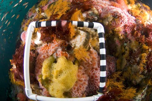
Researchers with Cordell Bank National Marine Sanctuary have conducted multiple camera sled video surveys (2004 and 2007) on the outer continental shelf to characterize the soft-bottom community and its habitat associations. Data were collected on animal presence and the characteristics of the seafloor habitats, including substrate type, slope, habitat complexity and depth.
Despite the coarse similarity in benthic substrates in soft-bottom areas of the outer continental shelf, there are subtle changes in the benthic habitats that are associated with differing species groups living on and in the sediment. For example, a change in the percentage of sand versus mud in the seafloor is associated with a change in community composition. In addition, patchy occurrences of certain taxa, such as sea whips and brittle stars, suggest that there are microhabitat features that determine biological patterns on the shelf. Future work is aimed at a closer examination of benthic communities and habitat associations in this area.
Trawling Impacts to Soft-Sediment Habitats and Communities
This study, conducted through a partnership between Monterey Bay National Marine Sanctuary and National Centers for Coastal Ocean Science, aims to quantify the recovery of seafloor microhabitats and associated benthic fauna along the central California coast following the cessation of fishing with mobile bottom fishing gear (e.g., otter trawls). This objective is being addressed by comparison of conditions at previously fished sites within an Essential Fish Habitat (EFH) groundfish closure area, located within Cordell Bank National Marine Sanctuary, and conditions in actively fished sites of comparable habitat type (unconsolidated sediments at depths of approximately 120 to150 meter depths) outside the closure area.
The EFH closure area was established in June 2006, however sampling stations within this area are at sites that actually have experienced little trawling since 2003, based on trawl records from NOAA Fisheries. Currently, fished sites outside the closure area are within the adjacent Greater Farallones National Marine Sanctuary. This work is intended to address the sanctuaries’ long-term goals of maintaining the natural state of biological communities and ecological processes while promoting the sustainability of local fisheries.
West Coast Bottom-Trawl Survey
The NOAA Fisheries Northwest Fisheries Science Center (NWFSC) conducts annual bottom-trawl surveys of U.S. West Coast groundfish resources. These surveys are designed to provide resource managers with fishery-independent data about the distribution, abundance and biological characteristics of commercially important fish species, particularly Pacific hake, sablefish, and many of the shelf and slope rockfish species.
Survey methodology has changed somewhat since the initiation of studies by the NOAA Fisheries Alaska Fisheries Science Center (AFSC), which conducted studies triennially from 1977 until 2001. Currently, NWFSC conducts annual surveys from the Canadian border to the Mexican border, using chartered commercial fishing vessels towing standardized nets. Separate shelf (55 to 500 meters) and slope (183 to 1,280 meters) surveys are performed.
Photos

Maps
F/V McArthur II Cruise Video Sled Tracklines - April 2004
[View Larger]
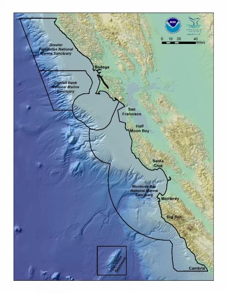
National Marine Sanctuaries of Central California
[View Larger]
Projects
Seafloor Mapping in Monterey Bay, Cordell Bank, and Gulf of the Farallones National Marine Sanctuaries
National Oceanic and Atmospheric Administration and U.S. Geological Survey scientists mapped and characterized seafloor areas on the continental shelf in three west coast National Marine Sanctuaries using side-scan sonar and underwater video technology.usSEABED: A USGS Pacific Coast Offshore Surficial Sediment Data and Mapping Project
The USGS will soon publish its first release of Pacific coast data from the usSEABED database, a map-based compilation of offshore surficial sediment data.Links
Bureau of Ocean Energy Management
BOEM is leading the nation toward a renewable energy future. We have issued the first-ever lease for offshore commercial wind energy development.http://www.boem.gov/
ONR Description of the Continental Shelf
Office of Naval Research description of ocean zones, including continental shelf.http://www.onr.navy.mil/Focus/ocean/regions/oceanfloor2.htm
UNEP Shelf Program
Information on data, rights of coastal states, and workshops revolving around continental shelf research.http://www.continentalshelf.org/