Overview
The Channel Islands are located within a unique geological region off the southern California coast. Over millions of years, large plates of the earth’s crust moved along fault lines, pushing against the coastline of Mexico and California and creating the coastal geography that is seen today.
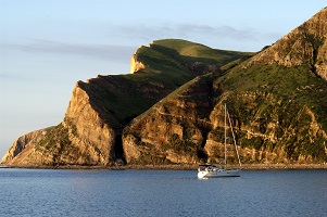
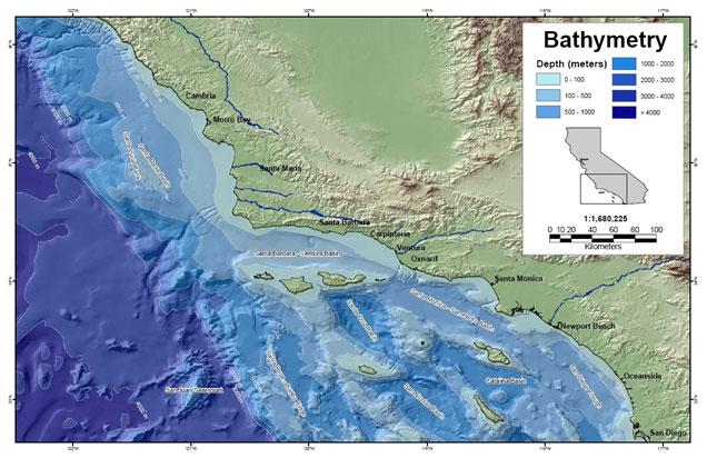
During this shifting, part of the southern California coast was rotated, resulting in the unusual east-west axis of the California coast just south of Point Conception, termed the Transverse Ranges, and the formation of the Channel Island chain along this coast. The Continental Borderland is the offshore section of the underwater geology that forms a wide continental shelf (Norris and Webb 1990). Unlike most wide continental shelves that consist of gently sloping platforms interrupted by low banks and occasional canyons, the Continental Borderland is a region of basins and elevated ridges (Norris and Webb 1990) (Fig 1). The Channel Islands are the portions of the ridges that rise above sea level.
Parallel to and situated between the California coast and the Channel Islands is the 1,950-foot deep Santa Barbara Basin. The seaward edge of the Continental Borderland (known as the Patton Escarpment) descends 13,200 feet to the deep ocean floor (Norris and Webb 1990). The highest point in the Channel Islands is the 2,450 foot Picacho Diablo on Santa Cruz Island and the deepest point within sanctuary boundaries is 5570 feet on the south side of Santa Cruz Island.
Oil and Natural Gas
More than 20 oil fields and several natural gas fields lie beneath the Santa Barbara Channel. Most are close to the mainland and several are accessed from offshore oil and gas platforms (Norris and Webb 1990). There are more than 40 naturally occurring oil and gas seeps in the Santa Barbara Channel (Norris and Webb 1990). The area is known to have one of the highest natural oil seepage rates in the world. Seeps at Coal Oil Point near Santa Barbara are estimated to discharge approximately 150-170 barrels (6,300-7,140 gallons) of oil per day (Hornafius et al. 1999).
Map: CINMS
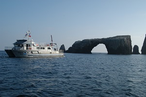
Photos
Maps
Projects
Channel Islands Naturalist Corps
Channel Islands Naturalist Corps volunteers are trained by CINMS and CINP to educate the public on board local marine excursion vessels conducting whale watch tours, natural history tours, and island trips. Channel Islands Naturalist Corps volunteers are trained to conduct citizen science on marine mammal field identification and general research. Research objectives of the program include the development of a comprehensive database of incidental marine mammal sightings and reports collected in the Santa Barbara Channel, CINMS and CINP.
Investigation of submerged shorelines in the Channel Islands and California Borderland
The Ocean Exploration Trust used scuba diving, high resolution autonomous surface vessel and ship-based mapping, and remotely operated vehicles to locate and characterize submarine shoreline terraces in the Channel Islands. Our 2017 team will continue their efforts in 2018 and will focus on: (1) locating sea caves at the 103-meter, 110-meter, and 120-meter paleo-shorelines on other submerged banks in the Borderland where the E/V Nautilus has subsequently collected bathymetric and backscatter maps since the 2017 cruise; (2) mapping the interior of several of the caves using a diver guided 3D imaging system; (3) using the ASV to locate possible cave entrances along deeper paleo-shorelines, (4) following that effort with a visual inspection of any new caves using the ROVs, and finally; (5) collecting water and/or sediment samples within selected caves to better understand the fish populations living within the caves through eDNA analysis.
Leveraging Drones and Autonomous Boats for Mapping and Monitoring of Shallow-Water Environments in the Channel Islands
Repeat mapping of shallow-water environments is essential for monitoring damage and recovery from episodic events (e.g., major storms), as well as chronic coastal erosion and habitat degradation. Bathymetric data covering the shallowest areas (<5 m water depth) can be challenging to collect, yet is critically needed for benthic habitat mapping. These data are also of interest to NOAA’s Office of Coast Survey (OCS), in areas such as the Channel Islands, where offshore breakers can prohibit vessels from surveying to the navigation area limit lime (NALL). Topobathymetric lidar from conventional (manned) aircraft is often an effective technology, but it can be too expensive for repeat monitoring at high temporal frequencies. Furthermore, the mobilization times can be prohibitive when data are needed immediately after a storm or other disaster.
Return to the Northern Channel Islands to Monitor Change Over Time, Inside and Outside of Marine Protected Areas
Marine Applied Research and Exploration (MARE) returned to complete ROV surveys around the northern Channel Islands MPAs 5 years after creating its deepwater baseline. The same 10 historical sites, both inside and outside of select MPAs, have been filmed and post-processed annually 2005-2009, with return surveys completed in 2014 and 2015.Southern California Seafloor Mapping Initiative
Place-based fisheries and coastal zone managers depend on fine scale bathymetry and habitat maps for an array of critical decisions including: navigational safety, disaster response, endangered species and fisheries management, conservation, research, energy development, and marine planning. Yet, in southern California nearly 90% of U.S. waters remain unmapped at an appropriate resolution. As of 2014, the unmapped area within NOAA’s Channel Islands National Marine Sanctuary (CINMS) was over 50% with the majority being characterized by single beam and lead line data from the 1930s. To address this critical information gap, offices across the NOAA family, together with other state and federal partners are uniting and filling the void.
Links
Big Sur Region Earth Sciences Bibliography
A compilation of citations pertaining to Earth sciences studies performed in the Big Sur region of central coastal California.http://www.ventanawild.org/news/fe02/geobib.html
California Coastal Commission - 1995 ReCAP Pilot Project, Monterey Bay Region: Coastal Hazards
This chapter summarizes ReCAP's investigation of shoreline hazard response -- protection of upland development by armoring, the permitting associated with existing armoring, the impacts from armoring, the policies which address shoreline protection, and the likely changes which will happen to the shoreline in the future assuming existing trends and policies continue.http://www.coastal.ca.gov/recap/chap3.html
California Coastal Mapping Project
The California Coastal Mapping Program is a comprehensive effort to combine seafloor mapping data with shoreline data to create seamless onshore-offshore maps of California's coastline.http://www.opc.ca.gov/2010/01/mapping-californias-coastal-areas/
California Geological Survey - An index to online geologic field trips, including coastal Central California
The California Geotour is an interactive index of Web pages of geologic field trip guides and related Web sites compiled by the California Geological Survey (CGS) for the benefit of all who have wondered about California's geologic features.http://www.conservation.ca.gov/cgs/Pages/Geotours.aspx
Central Coast Watershed Studies (CCoWS)
The Central Coast Watershed Studies (CCoWS) team is part of the Watershed Institute, in the Division of Science and Environmental Policy at California State University Monterey Bay. They conduct research on watersheds that feed into the MBNMS.http://ccows.csumb.edu/home/
CSUMB Seafloor Mapping Lab
At California State University Monterey Bay, students get hands-on research experience with mapping the seafloor. Find out more!http://seafloor.csumb.edu/index.html
Elkhorn Slough Tidal Wetland Plan
The purpose of this collaborative planning process is to conserve, enhance, and restore tidal habitats in the Elkhorn Slough watershed by developing strategies to address hydrological management issues.http://elkhornslough.org/tidalwetlandplan.htm
Investigating Earth Systems
A new, standards-based, Earth Science curriculum for the middle grades developed by the American Geological Institute in association with It's About Time Publishing.http://www.agiweb.org/ies/
MBARI - Current Research Projects
Learn about current research projects conducted by the Monterey Bay Aquarium Research Institute (MBARI).http://www.mbari.org/rd/projects/current_projects.html
MBARI - Mapping the Monterey Canyon
See how the Monterey Bay Aquarium Research Institute (MBARI) is involved in mapping the seafloor of the Monterey Bay National Marine Sanctuary.http://www.mbari.org/canyon/Mapping_Sections.htm
MBNMS Teacher Curriculum - The Land-Sea Connection
Teacher activity "The Land-Sea Connection": Conducting a Transect Along the Seafloor of the Monterey Bay National Marine Sanctuary, takes students in for a close look at the Sanctuary's benthic region. After becoming familiar with a bathymetric/topographic map of the area, students select a transect along the seafloor to study some of the geological, biological, and physical features that are present. Available in both Spanish and English.http://montereybay.nos.noaa.gov/educate/teachercurriculum/investigation2.html
Monterey Bay Aquarium - Student and Teacher Resources and Activities
The Monterey Bay Aquarium offers teacher and student resources including: species and habitat-specific information, live cams, classroom activities, and interactive online games.http://www.mbayaq.org/lc/
Monterey Bay National Marine Sanctuary Site Characterization - Geology
This site characterization of the Monterey Bay National Marine Sanctuary (MBNMS) summarizes available information about MBNMS geology.http://montereybay.noaa.gov/sitechar/geol.html
NOAA - Ocean Exploration Lesson Plans
Students of all ages can learn about the oceans with near real-time access to a series of multidisciplinary deep ocean explorations. The site offers a set of over 100 hands-on and standards-based lesson plans for student exploration and discovery. Using new technological "eyes" to see, sense, measure, image, and describe a little known ocean world, these lessons bring the excitement of late-breaking ocean discoveries into classrooms.http://oceanexplorer.noaa.gov/explorations/06davidson/background/edu/lessonplans.html
Oceanography Resources- Educational resources
This includes links to online courses about oceanography, museum and university exhibitions, sites dealing with significant oceanographic field programs and experiments, technical reports, glossaries and various other documents pertaining to oceanography and related areas.http://stommel.tamu.edu/%7Ebaum/ocean_education.html
Smithsonian Education - Ocean Planet Lesson Plan
Part of a set of multidisciplinary lesson plans from the Smithsonian, this lesson plan focuses on the ocean bottom features such as the continental shelf, deep ocean plain, and mid-ocean ridges, and includes downloadable student activities. Grades 3-8.http://www.smithsonianeducation.org/educators/lesson_plans/ocean/secrets/essay.html
Teach the Earth - Education Tools and Information for the Geosciences
The Science Education Resource Center's portal for Geoscience Faculty, providing information and resources to undergraduate educators. Much of the information is useful for high school teachers as well.http://serc.carleton.edu/
The Bridge - Ocean Sciences Teacher Resource Center
Materials and curricula related to many areas of study in the Monterey Bay. Be sure to check the data tip of the month archives. (Supported by the National Sea Grant Office, the National Oceanographic Partnership Program, and the National Marine Educators Association.)http://www.vims.edu/bridge/
USGS - Geology and Coastal Hazards in the Northern Monterey Bay, California, A Field Trip Guidebook
The purpose of this field trip is to explore the relationships between local geology, coastal hazards, and human influences in the northern Monterey Bay, which is a tectonically active, high wave energy coastal environment.http://geopubs.wr.usgs.gov/open-file/of00-438/
USGS - Monterey Bay Internet Map Server
Continental Shelf GIS for the Monterey Bay Area - selected data layers for the USGS seafloor for the Monterey Bay National Marine Sanctuary Project from USGS published reports and other sources.http://coastalmap.marine.usgs.gov/ArcIMS/website/usa/westcoast/cencal/montereybay/viewer.htm
USGS - Photo Tour from Año Nuevo to Santa Cruz, California
A digital photographic survey documenting the coastal morphology and stratigraphy between Point Año Nuevo and Santa Cruz, California, with precision-navigated overlapping images.http://pubs.usgs.gov/dds/dds-61/
USGS - Science Education
The U.S. Geological Survey (USGS) provides scientific information intended to help educate the public about natural resources, natural hazards, geospatial data, and issues that affect our quality of life. This website provides links to selected online resources to support education (K-12) and college inquiry and research.http://education.usgs.gov/
USGS Pacific Coastal & Marine Science Center
Homepage of USGS Division that conducts multidisciplinary scientific research in the coastal and offshore areas of California, Oregon, Washington, Alaska, Hawaii, and other US Pacific Islands; and in other waterways of the United States.http://walrus.wr.usgs.gov
USGS Western Region Coastal and Marine Geology - Education and Outreach Activities
Online education and outreach activities highlight geologic information helpful for the public, educators, students, scientists, businesses, and government agencies.http://walrus.wr.usgs.gov/pubinfo/