Overview
The majority of the Greater Farallones National Marine Sanctuary lies on the continental shelf, a region offshore of the estuarine, intertidal and subtidal environments in water depths of less than approximately 150 meters (500 feet).
The continental shelf is characterized by gently dipping seafloor and forms a relatively flat surface (hence the name, “shelf”) compared to the steeper and deeper continental slope. It extends nearly 50 kilometers (35 miles) in the gulf region – wider than in areas to the north and south of the sanctuary – and provides an especially large, relatively shallow habitat for foraging coastal and oceanic seabirds, marine mammals and fishes.
The shelf seafloor in the sanctuary consists mostly of sediment (sand, silt and minor amounts of broken shell material) along with areas of rock outcrops and coarse gravel. The most notable seafloor features are the large underwater sand dunes between the Farallon Islands and Point Reyes and the approximately 18-kilometer-long rocky ridge that includes Hurst Shoal, Farallon Islands, Fanny Shoals, Rittenberg Bank and Noonday Rock.
Benthic faunal communities differ according to these various habitat types.
Shelf Communities
Species that live in sediment-dominated areas of the continental shelf have adapted to the continuous shifting of sediments by ocean currents. For example, clams live permanently buried in the sand, extending their siphons to the surface to filter water in order to feed.
Dense fields of sea pens (Order Pennatulacea) are also found on the silty shelf. Each sea pen is a colony of polyps (small anemone-like individuals) that is anchored to the soft-sediment bottom and visually resembles old-fashioned quill pens.
Dungeness crabs, Cancer magister, one of the most economically important fisheries in the area, are concentrated on sandy and silty seafloor areas. They are opportunistic feeders, consuming clams, fishes, isopods and amphipods.
Flatfishes such as California halibut, Paralichthys californicus, and sanddabs, Citharichthys spp., use the sandy seafloor to evade predators and conceal themselves from prey by burying themselves up to their eyes. In addition, English sole, Paraphrys vetulus, spawn generally over shelf soft-sediment bottoms.
Areas of variable relief and rocky substrate on the shelf are often associated with high species diversity. The complex physical structure created by rocky, hard-bottom areas within the outer continental shelf region provides habitats for a very different suite of organisms than those found in soft-bottom areas: rockfishes, deep-water corals, sponges, anemones and others. This abundance of benthic life associated with hard substrates attracts pelagic predators, including seabirds and marine mammals, which hunt for fish and invertebrate prey along the bottom and in the waters above the seafloor.
Human Impacts
Conservation and management issues affecting sanctuary resources on the shelf include seabed disturbance (e.g., trawl disturbance and dumping of dredge spoils), marine debris, the presence of radioactive waste containers from the mid 1900s and accumulation of contaminants in the sediment and food web. In order to make decisions about these and other potential issues, scientists need more information, such as characterization of the sanctuary ecosystem, data on baseline conditions of the benthic community for future damage assessment, and knowledge of cultural resources and potential sunken polluters.
Monitoring
The following list includes some of the projects underway in the sanctuary. Please click on the Projects tab at the top of this page for more information.
Seafloor Mapping in Monterey Bay, Cordell Bank and Greater Farallones National Marine Sanctuaries
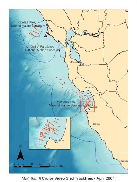
In April 2004, scientists from the National Oceanic and Atmospheric Administration (NOAA) and the U.S. Geological Survey conducted a 21-day research cruise aboard the NOAA Ship McArthur II. This study was one of the most extensive efforts to date to document the seafloor of the continental shelf in the three central California national marine sanctuaries.
Researchers mapped approximately 480 kilometers of the seafloor with side scan sonar and collected underwater video over approximately 200 kilometers to characterize the habitat types and diversity and the benthic assemblages of sea life on the continental shelf; including a first look at many areas. Results from this seafloor mapping study provide valuable characterization of sanctuary biology and geology that is useful as a foundation for management of the national marine sanctuaries.
Photos
Maps
F/V McArthur II Cruise Video Sled Tracklines - April 2004
[View Larger]
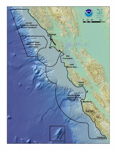
National Marine Sanctuaries of Central California
[View Larger]
Projects
Northern Central California Coast State Waters Mapping Project (NCCMP)
This project maps the state water seafloor habitats (MHHW out to 3 nm) from Año Nuevo to Bolinas (NCCMP Phase I) using bathymetric LIDAR and multibeam echo sounders (MBES) to obtain both bathymetry data and acoustic backscatter and reflectance imagery.Seafloor Mapping in Monterey Bay, Cordell Bank, and Gulf of the Farallones National Marine Sanctuaries
National Oceanic and Atmospheric Administration and U.S. Geological Survey scientists mapped and characterized seafloor areas on the continental shelf in three west coast National Marine Sanctuaries using side-scan sonar and underwater video technology.usSEABED: A USGS Pacific Coast Offshore Surficial Sediment Data and Mapping Project
The USGS will soon publish its first release of Pacific coast data from the usSEABED database, a map-based compilation of offshore surficial sediment data.Links
Bureau of Ocean Energy Management
BOEM is leading the nation toward a renewable energy future. We have issued the first-ever lease for offshore commercial wind energy development.http://www.boem.gov/
ONR Description of the Continental Shelf
Office of Naval Research description of ocean zones, including continental shelf.http://www.onr.navy.mil/Focus/ocean/regions/oceanfloor2.htm
UNEP Shelf Program
Information on data, rights of coastal states, and workshops revolving around continental shelf research.http://www.continentalshelf.org/