Overview
In the deep waters of the Greater Farallones National Marine Sanctuary lie unique organisms and dramatic geological features. Less than 80 kilometers (50 miles) offshore, the steep continental slope descends into the deep sea to depths beyond 200 meters (660 feet) with the deepest parts of the sanctuary exceeding 2,000 meters.
The deep sea is the largest habitat on earth and is home to many relatively unknown biological communities. It is only in the past two decades that better technologies have allowed humans to view previously unseen areas: the development of camera-equipped remotely operated vehicles (ROVs) and manned submersibles provide a new window on this world.
In the “old” days, exploration of deep-sea life involved dragging a net along the bottom or through the open water. Delicate animals such as jellies came back to the ship damaged beyond recognition. Today, ROVs have substantially increased our knowledge because they allow us to observe animals in their natural habitat and better understand how they interact with each other and with their environment.
There are two major habitats in the deep sea:
- The “midwater”: Animals such as fishes, squid and jellies live their entire lives floating here, in the vast area where one can see neither the seafloor below nor the sunlight above. Small bacteria and crustaceans are also abundant in this zone.
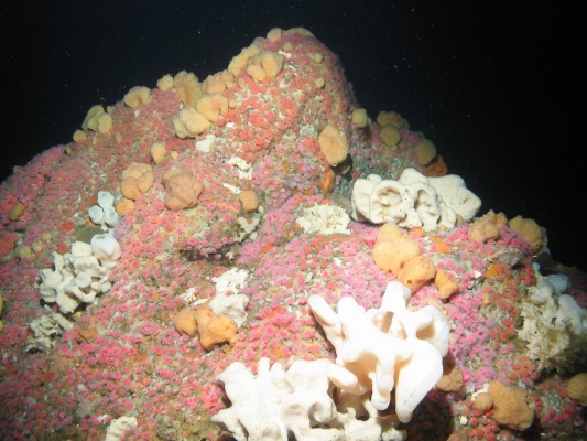
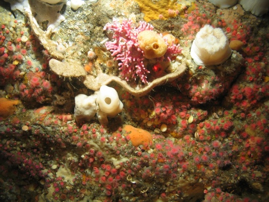
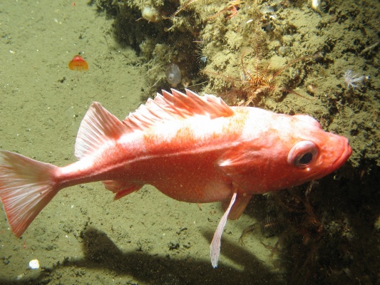
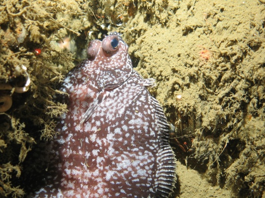
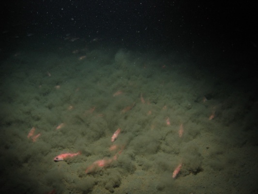
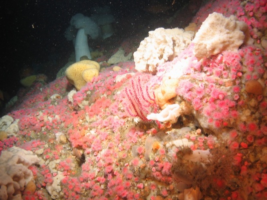
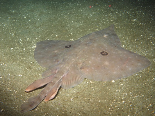
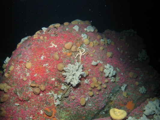
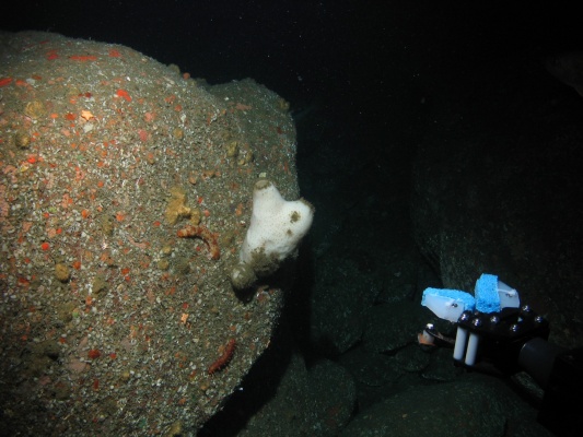
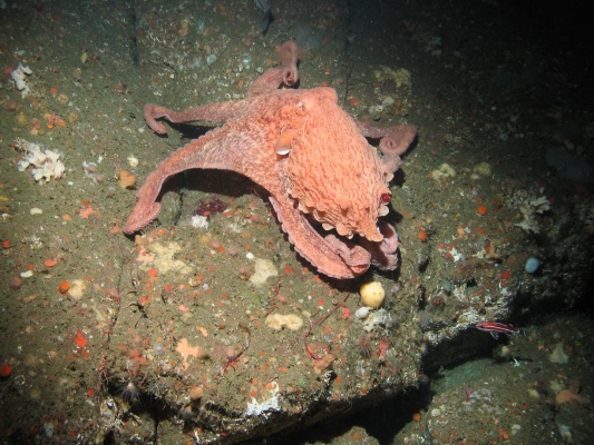
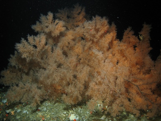
- The seafloor, or “benthos”: This habitat is dominated by microscopic animals living in the mud, a diverse array of larger surface-dwelling invertebrates (sea stars, urchins, sponges, brittle stars, etc.) and fishes that live on or just above the seafloor. The biological diversity of the sanctuary is due, in part, to diverse benthic habitats, ranging from huge expanses of soft sediment to hardened mud and rock. Rock outcrops on deep-sea canyon walls provide a hard surface on which sponges, anemones and other fixed organisms live.
Deep-sea life is adapted to dark, cold, high-pressure and low-oxygen conditions. Compared to the relatively shallow water habitats (less than 200 meters) along the California coast, food is generally scarce at depth. Some animals adjust to these harsh conditions, making use of a habitat few others can tolerate; it reduces competition for food and their chances of being eaten.
Organisms have adapted in a variety of ways. Natural light penetrates to only about 300 meters, so marine plants, which need sunlight, are absent below this depth. Because it is dark, many animals don’t have the ability to see; others have extraordinarily sensitive eyes to pick up what little light is available. Many deep-sea organisms make their own light – a chemical reaction called bioluminescence. Bright displays of light may be used to communicate, attract mates, create confusion (and thus avoid a predator) or lure food.
The cold water slows an animal’s metabolism. Most deep-sea animals move very slowly, and some employ special enzymes to deal with this unique environment. Slow metabolism may account for the long lives of deep-sea organisms, including certain rockfishes that can live for more than 200 years. Other animals, like sea cucumbers, carry high levels of unsaturated fat in their cell walls to maintain membrane fluidity in this cold, high-pressure environment.
Food is generally limited in the deep sea, so finding it and capturing it is more difficult. Many animals feed on an array of discarded biological material called “detritus,” which rains down from above as a result of the activities of animals in shallower water.
Whatever these animals discard or shed provides food that sinks to the seafloor for scavengers and mud-feeding organisms like brittle stars and sea cucumbers. On occasion, large “food falls,” like dead whales or dead kelp, sink from above, attracting large numbers of animals that come to take advantage of the bounty.
Human Interaction
It is essential to monitor human impacts on the ocean so that we can understand how our activities change our environment. A clear understanding of these effects can help resource managers and policy makers develop sound conservation strategies.
Conservation and management issues affecting sanctuary resources in the deep sea include seabed disturbance, non-sustainable fishing and radioactive waste.
- Bottom trawling: This practice is widely believed to have negative impacts on benthic habitats, such as modification of the substrate, disturbance of soft-bottom communities and removal of non-target fish species. The structure of entire seafloor communities is at risk from this fishery practice. Currently, there is an incomplete picture about the extent of these impacts in the sanctuary, but the use of trawl gear is an ongoing source of concern.
- Non-sustainable fishing: In June 2006, the Pacific Fishery Management Council and National Oceanic and Atmospheric Administration (NOAA) Fisheries closed large portions of the continental slope to trawling in order to protect essential fish habitat for groundfishes. In addition, closures called Trawl Rockfish Conservation Areas (RCAs) have been established to minimize the bycatch of overfished rockfishes. RCA boundaries, however, may change during the year. Trawling is not allowed in state waters.
- Radioactive Waste: Approximately 47,800 barrels of low-level radioactive waste were disposed between 1946 and 1970 (before sanctuary designation, in 1981) in the area referred to as the “Farallon Islands radioactive waste dump.” Although the containers were to be dumped at three designated sites, they are actually strewn over a 1400-square-kilometer (540-square-mile) area in depths ranging from 100 meters to more than 2,000 meters within the gulf. Research results to date are inconclusive on the impacts from possible radioactive leakage on the marine ecosystem. The new sanctuary management plan addresses the need to evaluate the condition of, and actual impacts on, sanctuary resources and qualities from the Farallon Islands radioactive waste dump.
Monitoring
Experts from many different fields – biologists, geologists, chemists, engineers and physical oceanographers – all study the deep sea, seeking to understand how the ocean works.
This work is important for many reasons; the size of the deep sea (covering 63 percent of the earth’s surface) means that we should know as much as possible about this ecosystem. Scientists strive to understand how deep-sea animals are different from shallow-water species and what adaptations they have developed in response to the deep ocean’s unique environment.
The deep sea may also provide economic opportunities. Cancer-fighting drugs developed from sea sponges or other marine organisms may some day provide new pharmaceuticals. Researchers are also investigating the seafloor for new forms of energy. However, one of the best reasons to study the deep sea may be simple curiosity about all the amazing creatures and geological features hidden in its depths.
Photos

Maps
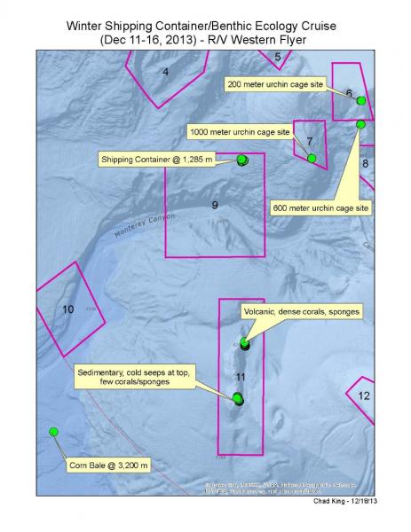
Winter Shipping Container/Benthic Ecology Cruise (Dec 11-16, 2013) Study Sites
[View Larger]
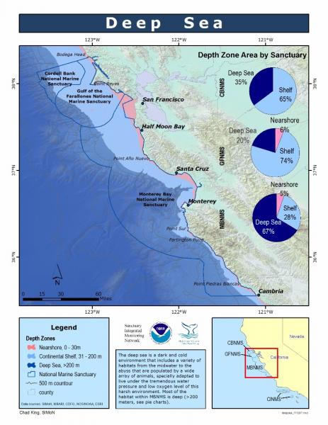
Deep Sea (Depth Zone Area by Sanctuary)
[View Larger]
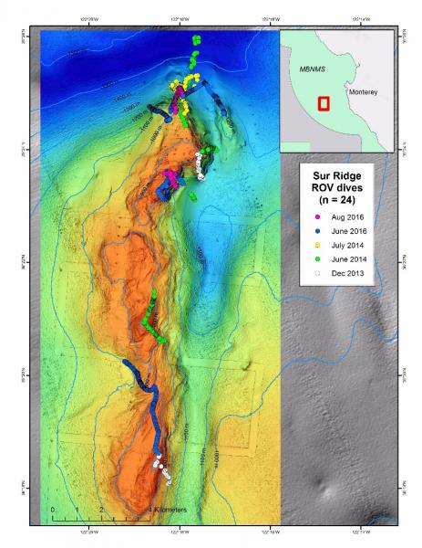
ROV Dives on Sur Ridge Through August 2016
[View Larger]
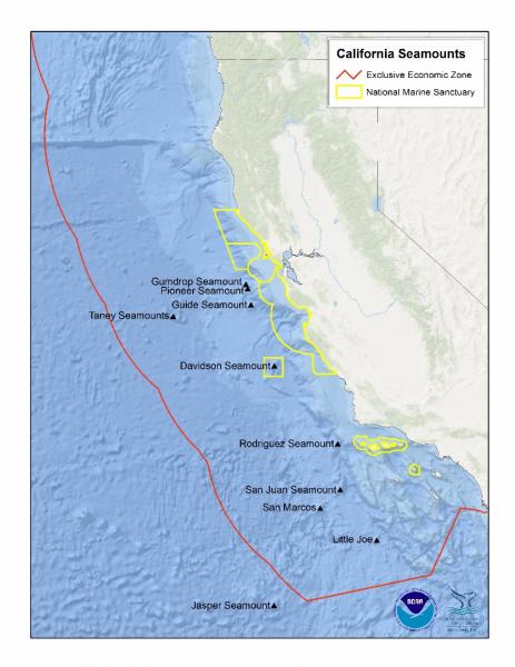
California Seamounts
[View Larger]
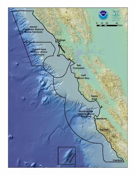
National Marine Sanctuaries of Central California
[View Larger]
Projects
California Cooperative Oceanic Fisheries Investigations (CalCOFI)
The California Cooperative Oceanic Fisheries Investigations (CalCOFI) was formed in 1949 to study the ecological aspects of the Pacific sardine population collapse off California. Today, the focus has shifted to the study of the marine environment off the coast of California, the management of its living resources, and monitoring the indicators of El Nino and climate change.
NOAA's Deep-Sea Coral FY2010 Assessment for the U.S. West Coast
The marine region off the coast of Washington, Oregon and California accounts for about 7% (778,628 km2) of the total area of the U.S. Economic Exclusive Zone and contains extensive deep-sea coral (DSC) communities. NOAA manages five National Marine Sanctuaries (NMS) on the West Coast: the Channel Islands (CINMS), Monterey Bay (MBNMS), Gulf of the Farallones (GFNMS), Cordell Bank CBNMS), and Olympic Coast (OCNMS). All contain deep-sea corals.Survey of deep-water coral and sponge habitats along the West Coast of the US using a remotely operated vehicle
Remotely operated vehicle surveys were conducted from a NOAA ship (the FSV Bell M. Shimada) during a six‐day transit November 1‐5, 2010 between San Diego, CA and Seattle, WA. The objective was to locate and characterize deep‐sea coral and sponge ecosystems at several recommended sites in and adjacent to NOAA sanctuaries.Links
American Museum of Natural History - Explore the Deep Oceans
Deep Sea teacher resources and curriculum for grades 6 and up. Topics include: Explore the Deep Ocean, How Deep Is Deep?, Under Pressure, and Dispatch from the Deep.http://www.amnh.org/education/resources/dsv/explore.php
Discovering Hidden Habitats: MBARI & NOAA
Join NOAA and the Monterey Bay Aquarium Research Institute's (MBARI) 2002 expedition to the deep trenches of the Monterey canyon where they discovered previously unknown species.http://www.youtube.com/watch?feature=player_embedded&v=jVrugjn79XY#!
Eisenhower National Clearinghouse: Deep Sea Missions
This video and lesson guide is one of a series whose purpose is to demonstrate the applicability of mathematics to real careers. Deep Sea Missions follows James McFarlane in his duties as chief Remotely Operated Vehicle pilot for the Monterey Bay Aquarium Research Institute. Students join McFarlane as he takes Mary Silver, a professor of marine biology, to the ocean floor to collect fragile marine samples.http://www.enc.org/resources/records/0,1240,003647,00.shtm
MBARI - Cold Seeps
Learn about the benthic communities that are linked to the seepage of methane and sulfide rich fluids from the ocean floorhttp://www.mbari.org/benthic/coldseeps.htm
MBARI - Current Research Projects
Learn about current research projects conducted by the Monterey Bay Aquarium Research Institute (MBARI).http://www.mbari.org/rd/projects/current_projects.html
MBARI - Deep Sea Benthic Invertebrate Guide
Find digital images of small organisms (macrofauna) collected in sediment core samples taken between 200 - 3600 m near Monterey Bay, California by the Monterey Bay Aquarium Research Institute (MBARI).http://www.mbari.org/benthic/fauna.html
MBARI - Deep-Sea Guide
A web-based system that allows for the correlation of visual, descriptive, and observational data with environmental data from multiple sources by providing tools for searching, identifying, and examining occurrence data (e.g., depth, time, abundance) for biological, geological, and experimental observations.http://dsg.mbari.org/
MBARI video of trash in the deep sea
Monterey Bay Aquarium Research Institute shares video of trash observed during deep sea missions with their ROV.http://www.youtube.com/watch?v=mOZngsJU2k0
Monterey Bay Aquarium - Mission to the Deep
Learn more about the fascinating world of the deep sea.http://www.montereybayaquarium.org/efc/efc_mbari/mbari_home.aspx?bhcp=1
Monterey Bay Aquarium - Student and Teacher Resources and Activities
The Monterey Bay Aquarium offers teacher and student resources including: species and habitat-specific information, live cams, classroom activities, and interactive online games.http://www.mbayaq.org/lc/
Monterey Bay National Marine Sanctuary - Cold Seep Communities
A comprehensive and educational scientific characterization of an important habitat in the Monterey Bay Sanctuary.http://montereybay.noaa.gov/sitechar/cold.html
Monterey Bay National Marine Sanctuary - Deeper Bottom Habitats
A comprehensive and educational scientific characterization of an important habitat in the Monterey Bay Sanctuary.http://montereybay.noaa.gov/sitechar/deep.html
NOAA - Ocean Exploration Lesson Plans
Students of all ages can learn about the oceans with near real-time access to a series of multidisciplinary deep ocean explorations. The site offers a set of over 100 hands-on and standards-based lesson plans for student exploration and discovery. Using new technological "eyes" to see, sense, measure, image, and describe a little known ocean world, these lessons bring the excitement of late-breaking ocean discoveries into classrooms.http://oceanexplorer.noaa.gov/explorations/06davidson/background/edu/lessonplans.html
NOAA - Ocean Explorer Program
Explore the ocean realm with NOAA. This Web site chronicles the adventures and discoveries of NOAA's at-sea science and education teams.http://oceanexplorer.noaa.gov/welcome.html
NOAA - Ocean Explorer Program
Explore the ocean realm with NOAA. This Web site chronicles the adventures and discoveries of NOAA's at-sea science and education teams.http://oceanexplorer.noaa.gov/
Ocean Explorer Gallery
Great resource for images and sounds. Collections include maps, living ocean, sound in the sea, cultural heritage, history, technology and explorers.http://www.oceanexplorer.noaa.gov/gallery/gallery.html
Project Oceanography - MBNMS
A University of South Florida distance-learning program for middle school students taught by scientific experts. "Unit II: Monterey Bay National Marine Sanctuary" contains teacher packets on various topics.http://www.marine.usf.edu/pjocean/packets/sp02/sp02.htm
The Pacific Shark Research Center (PSRC) at Moss Landing Marine Laboratories
The PSRC at MLML conducts both basic and applied scientific research on the biology of Pacific Ocean chondrichthyans, serves as a resource center for scientific information on sharks to public policy makers, and participates in collaborative research on national and international issues involving shark, ray, and chimaera biology.http://psrc.mlml.calstate.edu/
University of Delaware - Voyage to the Deep
Learn about an expedition to the deep sea and what scientists found there.http://www.ocean.udel.edu/deepsea