Overview
A bank is an elevation of the seafloor located on the continental shelf, over which the water depth is relatively shallow. These features are of continental origin and can cover extensive surface area but do not extend thousands of meters into the water column.
By contrast, seamounts are mainly volcanic in origin, rise a considerable height from great depths on the continental rise and are limited in length across the summit.
Despite their differences in scale, both banks and seamounts are isolated in space and have higher elevation and a different substrate than the surrounding seabed. The vertical structure, habitat complexity and rocky substrate of banks and seamounts support a very different biological assemblage than the surrounding soft bottom typical of the continental shelf and slope. Because these rocky features extend up into the water column, they provide ideal habitat for attached sessile invertebrates that depend on currents to deliver their food. The hard substrate is also favorable for settlement of larvae from the water column.
Cordell Bank is the centerpiece of Cordell Bank National Marine Sanctuary and is located about 80 kilometers (50 miles) northwest of San Francisco and 32 kilometers west of the Point Reyes lighthouse. It is approximately 7 kilometers wide and 15 kilometers long and sits on the edge of the continental shelf. Shelf depths at its base are about 91 meters (300 feet), with upper pinnacles reaching to within 35 meters of the ocean surface. The bank makes up approximately 2 percent of the total sanctuary area.
Cordell Bank was created as part of the southern Sierra Nevada mountain range nearly 100 million years ago. About 30 million years ago, the north-moving Pacific plate sheared off a block of the North American plate containing Cordell Bank, and since that time, the bank has been migrating slowly north. Its granite structure is a link to its geologic history as well as an indication of its common origin with the Farallon Islands to the south.
Recent discoveries of sedimentary rock on Cordell Bank have intrigued geologists and suggest that the bank may be more geologically complex than previously thought. Between 20,000 and 15,000 years ago, when sea level was about 110 meters lower than it is today, Cordell Bank would have been entirely exposed. Boulder fields at its base on the western side may be indicative of an ancient shoreline.
A percentage of Cordell Bank is made up of consolidated granite reef, but much of the bank is a heterogeneous mixture of rock reef, boulders, cobbles, sand and mud. Its perimeter includes large expanses of white sand waves on the eastern side and relatively flat mud on the northern and western sides. The central portion has extensive reef systems and the shallowest pinnacles (as shallow as 35 meters), while the northern half is deeper, with mixed bolder and reef habitats. Throughout the bank, rocky reefs are cut by sand channels as well as mixed habitats of sand, boulders and cobbles.
The bathymetry and location of Cordell Bank combine to make it a very productive marine environment. The bank is situated downstream from a major and persistent upwelling center at Point Arena to the north. Nutrients and productivity emanating from that area are carried over the bank and sustain a thriving biological community. In addition to the Point Arena upwelling center, localized upwelling may also contribute to productivity at Cordell Bank.
The bank is located on the edge of an underwater peninsula and is surrounded by deep water on three sides. Within 11 kilometers of its western edge, the seafloor drops to 1,829 meters at the sanctuary’s western boundary. Data suggest that, as deeper water encounters the base of the bank on the northern edge, the water mass moves up and over the bank. This localized upwelling would be one more mechanism delivering food and nutrients to organisms living on or around Cordell Bank.
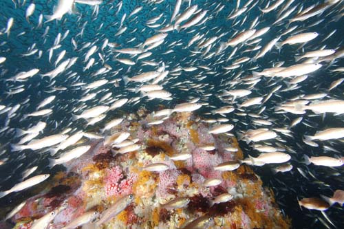
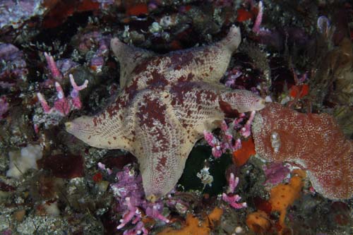
Sponges, hydrocorals, tunicates, anemones, gorgonians, solitary corals and hydroids compete for space on the upper-reef areas. More mobile animals like decorator crabs, sea stars, sea cucumbers, snails and demersal fishes move over the invertebrate carpet. Cover on the upper reef areas exceeds 100 percent, as animals are layered one on top of the other.
This living reef also provides critical habitat for first-year juvenile rockfishes (Sebastes spp.) that settle out of the water column as they transition from a pelagic to benthic life stage. Adult rockfishes, lingcod and other benthic fishes also inhabit the complex habitats within the structure of Cordell Bank. The most conspicuous invertebrates occurring in the deeper reef areas include octopus, crinoids, white plumed anemones, sea stars and tube polychaetes.
Habitat loss and fragmentation are perhaps the most serious threats confronting all species of wildlife today. Many of the activities and conditions that indirectly affect marine life are first experienced as an alteration or disturbance to their habitat.
Activities that currently have the greatest potential impact on Cordell Bank are the use of bottom-tending fishing gears, the deposition of lost fishing gear and other marine debris, the introduction of invasive species, and the construction and placement of cables and pipelines on the bank.
Gear restrictions and area closures associated with the Rockfish Conservation Areas (RCAs) and Essential Fish Habitat (EFH) designations have reduced potential habitat impacts from fishing. Regulations protecting the bank from invasive species introductions and seabed disturbance form part of the sanctuary’s revised management plan.
Monitoring
Benthic Community Characterization and Monitoring
The Cordell Bank National Marine Sanctuary, in partnership with the National Oceanic and Atmospheric Administration (NOAA) Fisheries Laboratory in Santa Cruz, the U.S. Geologic Survey (USGS), California Academy of Sciences and the California Department of Fish and Game, conducted a study to classify habitats and monitor fishes and macro-invertebrates on and around Cordell Bank. Benthic transects were monitored annually from 2002 to 2005. The sanctuary plans to continue the monitoring program in the future; however, this is dependent upon funding levels.
Underwater surveys of fishes, invertebrates and their habitats were conducted on and around Cordell Bank using direct observation and video-transect methods from an occupied research submersible (Delta). Transects were distributed over the bank to sample all bank habitats and associated biota.
The data provided the sanctuary staff with a species inventory of fishes and benthic invertebrates. Long-term data may be used to identify habitat affinities for species complexes, develop habitat suitability models and provide a foundation to evaluate change over time.
Photos
Maps
California Seamounts
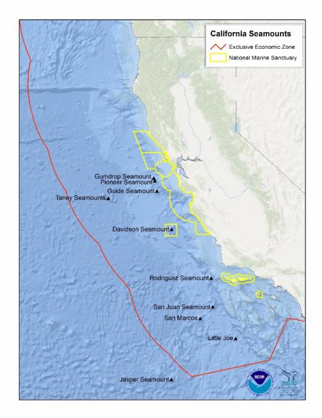
[View Larger]
Projects
Cordell Bank Habitat Characterization and Biological Monitoring
In 2002, sanctuary staff and collaborators initiated a program to quantify the diversity, distribution and abundance of habitats, fishes and invertebrates on and around Cordell Bank and follow these parameters over time. Underwater surveys of macrofauna (fish and invertebrates) and habitats are conducted using direct observation and video transects from an occupied submersible (Delta).Hypoxia monitoring at Cordell Bank
Researchers at Bodega Marine Laboratory at the University of California, Davis and Cordell Bank National Marine Sanctuary (CBNMS) have been monitoring dissolved oxygen (DO) levels in the sanctuary since 2014. Moored instruments were deployed at two sites on Cordell Bank to collect DO and temperature data, and in 2016 a conductivity recorder was added to collect salinity data.
Re-Discovering Cordell Bank: Dive Expedition 30 Years Later
In 2010, a technical dive team completed a series of deep dives on Cordell Bank; this was the first dive expedition to Cordell Bank since Cordell Expedition divers explored the Bank between 1977 and 1985. The team was able to accomplish all the mission's science objectives including photo and video documentation and sample collection of invertebrates. This information will allow sanctuary staff to evaluate changes that have occurred on the bank since the original survey 30 years ago, and establish species composition and reef conditions in 2010. The 2010 data will allow sanctuary staff to analyze future changes that may be associated with changing climate conditions.Seafloor Mapping in Monterey Bay, Cordell Bank, and Gulf of the Farallones National Marine Sanctuaries
National Oceanic and Atmospheric Administration and U.S. Geological Survey scientists mapped and characterized seafloor areas on the continental shelf in three west coast National Marine Sanctuaries using side-scan sonar and underwater video technology.Links
Corals of Davidson Seamount
KQED video of the deep-sea corals at Davidson Seamount.http://science.kqed.org/quest/video/exploring-corals-of-the-deep/
Davidson Seamount Management Zone - Management Plan
2013 technical report on the Davidson Seamount Management Zone, including an updated Management Planhttp://montereybay.noaa.gov/research/techreports/trmbnms2013.html
Davidson Seamount Management Zone - Threats Assessment
2012 technical report on threats potentially impacting the Davidson Seamount Management Zonehttp://montereybay.noaa.gov/research/techreports/trmbnms2012.html
Davidson Seamount Taxonomic Guide
2008 guide to species observed on Davidson Seamounthttp://montereybay.noaa.gov/research/techreports/trburton2008.html
Discovering Hidden Habitats: MBARI & NOAA
Join NOAA and the Monterey Bay Aquarium Research Institute's (MBARI) 2002 expedition to the deep trenches of the Monterey canyon where they discovered previously unknown species.http://www.youtube.com/watch?feature=player_embedded&v=jVrugjn79XY#!
MBARI - Current Research Projects
Learn about current research projects conducted by the Monterey Bay Aquarium Research Institute (MBARI).http://www.mbari.org/rd/projects/current_projects.html
MBARI - Deep-Sea Guide
A web-based system that allows for the correlation of visual, descriptive, and observational data with environmental data from multiple sources by providing tools for searching, identifying, and examining occurrence data (e.g., depth, time, abundance) for biological, geological, and experimental observations.http://dsg.mbari.org/
MBARI - Seamounts Research Highlights
Learn about the research that is being done on underwater volcanoes (seamounts) at the Monterey Bay Aquarium Research Institute (MBARI).http://www.mbari.org/volcanism/Seamounts/
MBNMS – Davidson Seamount
Main link to MBNMS web site that covers Davidson Seamount.http://montereybay.noaa.gov/research/dsmz/welcome.html
Monterey Bay Aquarium - Student and Teacher Resources and Activities
The Monterey Bay Aquarium offers teacher and student resources including: species and habitat-specific information, live cams, classroom activities, and interactive online games.http://www.mbayaq.org/lc/
NOAA - Davidson Seamount Exploration
Technological advances have allowed exploration of one of the largest "underwater islands" off the coast of the U.S. See what the exploration entails and what new and exciting life forms are being discovered there.http://oceanexplorer.noaa.gov/explorations/02davidson/davidson.html
NOAA - Mountains in the Sea Lesson Plans
The Mountains in the Sea: Exploring the New England Seamount Chain Expedition presents a unique opportunity to engage explorers of all ages as we journey to a world that few have seen.http://oceanexplorer.noaa.gov/explorations/03mountains/background/education/education.html
NOAA - Ocean Exploration Lesson Plans
Students of all ages can learn about the oceans with near real-time access to a series of multidisciplinary deep ocean explorations. The site offers a set of over 100 hands-on and standards-based lesson plans for student exploration and discovery. Using new technological "eyes" to see, sense, measure, image, and describe a little known ocean world, these lessons bring the excitement of late-breaking ocean discoveries into classrooms.http://oceanexplorer.noaa.gov/explorations/06davidson/background/edu/lessonplans.html
NOAA Explorations - Davidson Seamount
Follow an expedition to the Davidson Seamount located 120 miles southwest of Monterey, California. Student can follow the expedition through the mission plan, cruise logs, images both above and below the water line, interviews with the research scientists and a look at the technology used in such an adventure.http://oceanexplorer.noaa.gov/explorations/02davidson/davidson.html
NOAA Ocean Explorer - Sounds in the Sea
Underwater hydrophones were installed at the Pioneer Seamount to learn more about ocean noise.http://oceanexplorer.noaa.gov/explorations/sound01/sound01.html
NOAA Photo Library
NOAA's photo library contains incredible shots of an amazing array of animals, technology, scientists, and images of historical treasures. Site also offers search function for images.http://www.photolib.noaa.gov
NOAA Vents Program - Acoustic Monitoring
Underwater acoustic monitoring is helping scientists to understand the geological activity in the ocean, the distribution of marine animals, the effect that noise has on marine life and more.http://www.pmel.noaa.gov/vents/acoustics.html
Review of Resource Management Strategies for Protection of Seamounts
http://sanctuaries.noaa.gov/science/conservation/seamount14.html
Sanctuaries Joint Management Plan - Davidson Seamount
NOAA is considering protecting the resources and qualities of the Davidson Seamount through inclusion in the Monterey Bay National Marine Sanctuary.http://sanctuaries.nos.noaa.gov/jointplan/mb_davidson.html
Seamounts Online
An online resource designed to gather and provide information on species found in seamounts as well as to facilitate research in seamount ecology.http://seamounts.sdsc.edu/
SFSU Pacific Oceanography Project - Gallery of Underwater Sounds
See what different underwater sounds "look" like.http://www.physics.sfsu.edu/~seamount/gallery.html
The Bridge - Ocean Sciences Teacher Resource Center
Materials and curricula related to many areas of study in the Monterey Bay. Be sure to check the data tip of the month archives. (Supported by the National Sea Grant Office, the National Oceanographic Partnership Program, and the National Marine Educators Association.)http://www.vims.edu/bridge/