Overview
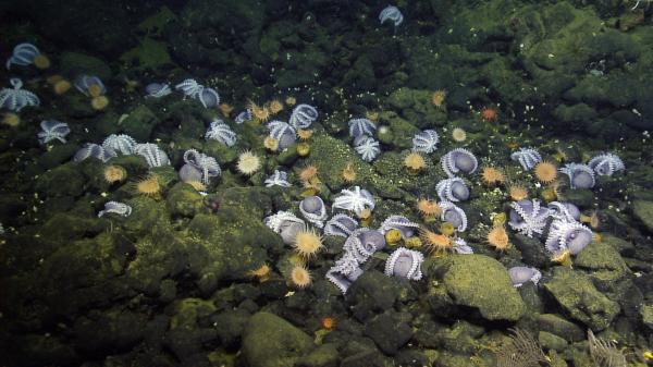
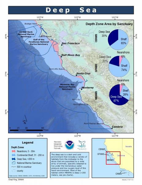
The deep sea is a dark, cold environment that includes a variety of habitats from the mid-water region to the abyss; these are populated by a wide array of animals that are specially adapted to live under the tremendous water pressure and low oxygen level of this harsh environment. In recent years, improved sampling techniques and technologies have shown that the diversity of deep-sea fauna is greater than once thought.
Based on the topography of the seafloor, the deep sea begins at the continental shelf break, at a depth of approximately 200 meters (650 feet). Beyond the shelf break, the continental slope descends through the deep sea to the ocean floor.
Of the total seafloor area in the sanctuary, approximately two-thirds (9,164 square kilometers, or 3,538 square miles) are located in the deep sea. This region also encompasses two distinct pelagic zones: the mesopelagic zone, which starts 200 meters below the surface and extends to about 1,000 meters; and the bathypelagic zone, from 1,000 meters down to the seafloor.
Although the deep sea encompasses 98 percent of all living space on the planet by volume, it is among the least understood ecosystems because of the challenges inherent in accessing it. Marine scientists claim that we know more about space than we do about this remote environment.
To reach the ocean’s depths, scientists require a platform from which to deploy sampling or observational gear. Today, in addition to net sampling, manned and unmanned research submersibles are deployed from research ships to collect data and make observations in this remote environment.
The deep sea comes very close to shore in the sanctuary through the heads of several canyons (Monterey Canyon is the largest), making deep water relatively easy to access here.
Conservation and management issues affecting sanctuary resources in the deep sea include seabed disturbance, nonsustainable fishing and carbon dioxide (CO2) sequestration.
- Bottom trawling: This practice is widely believed to have negative impacts on benthic habitats, such as modification of the substrate, disturbance of soft-bottom communities and removal of non-target fish species. The structure of entire seafloor communities is at risk from this fishery practice. Currently, there is an incomplete picture about the extent of these impacts in the sanctuary, but the use of trawl gear is an ongoing source of concern.
- Nonsustainable fishing: In June 2006, the Pacific Fishery Management Council and NOAA Fisheries closed large portions of the continental slope to trawling in order to protect essential fish habitat (EFH) for groundfishes. In addition, closures called Trawl Rockfish Conservation Areas (RCAs; from 183 to 274 meters’ depth in the Monterey Bay National Marine Sanctuary) have been established to minimize the bycatch of overfished rockfishes. RCA boundaries, however, may change during the year. Trawling is not allowed in state waters.
- CO2 sequestration: International agencies are investigating deep-sea carbon sequestration as one possible mitigation technique for emissions of CO2, one of the primary greenhouse gases involved in global warming. Scientists at the Monterey Bay Aquarium Research Institute (MBARI) have conducted some of the first experiments aimed at understanding the chemistry and physics of CO2 in the deep sea and the ecological effects of CO2 sequestration. The release of CO2 on the seafloor caused a change in seawater chemistry and high mortality of organisms living in the sediments. Results indicate that large changes in seawater chemistry will cause high mortality rates for nearby deep-sea communities.
Monitoring
Archiving of Mid-Water and Benthic Survey Data at Moss Landing Marine Laboratories
Since the early 1970s, faculty and students in Marine Ecology, Invertebrate Zoology and Ichthyology at Moss Landing Marine Laboratories (MLML) have participated in class cruises to survey the fishes and invertebrates in shallow-benthic (50 and 150 meters), deep-benthic (650 meters) and mid-water (400 and 800 meters) habitats in Monterey Bay. Sampling is conducted using various types of trawling equipment.
Available biological information includes identification of the organisms to the lowest possible taxa, their numbers, and sometimes sizes or size ranges. Survey data are entered into a database, and maps and charts are scanned.
As of March 2005, 158 invertebrates species (and 358 others identified to genus or higher) and 231 fish species (and 55 other fish taxa) have been observed. Definite, predictable changes in fish assemblages were observed with depth. During some warm-water events, such as El NiÒo events, fishes more commonly observed in southern California were collected from sanctuary waters.
Patterns and Dynamics of Benthic Soft-Sediment Faunal Communities
Since 1994, scientists at MBARI have been monitoring megafaunal populations on the deep seafloor (200 to 1,000 meters) at Smooth Ridge in Monterey Bay to determine patterns of abundance and measure changes over time. These data will provide a measure of the interannual variation in community structure in the region.
One interesting finding of this monitoring program is the horizontal patchiness in the abundance of some species. For example, four shelf-dwelling rockfish species are much more abundant at one end of the 200-meter transect than at the other end. In addition, the structure of the seafloor community is variable from year to year, particularly along the shallower (200 meters) transect.
Abyssal Fauna Associated With a Whale Fall in Monterey Canyon
In 2002, MBARI scientists discovered an unusual deep-sea community associated with the remarkably well-preserved carcass of a gray whale, Eschrichtius robustus, at 2,891 meters’ depth in the axis of Monterey Canyon.
As a result of the whale fall, an intense burst of approximately 20,000 kilograms (44,092 pounds) of organic material was exported to the typically food-poor seafloor. Particularly noteworthy was the absence of large scavengers, the presence of a number of opportunistic deep-sea species and the abundance of unusual polychaetes – two of which actually digest bone and are new to science.
Since its discovery, the whale fall has been revisited, which has allowed scientists to document faunal community changes in one of the deepest large food falls known to date. MBARI continues to monitor this and other whale fall communities. Whale falls provide opportunities to study localized effects of organic enrichment at depths as well as the unusual animals that rely exclusively on these very transient habitats.
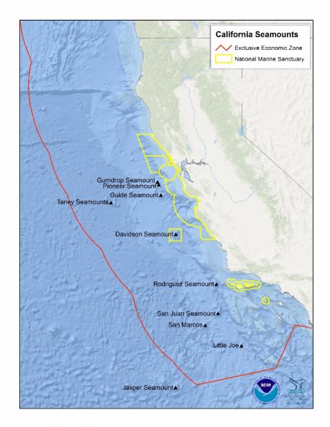
Davidson Seamount Exploration
In 2002 and 2006, a diverse group of scientists explored and began characterizing Davidson Seamount; one of the largest seamounts on the West Coast located beyond the sanctuary boundary. For more information, see the Seamounts Overview.
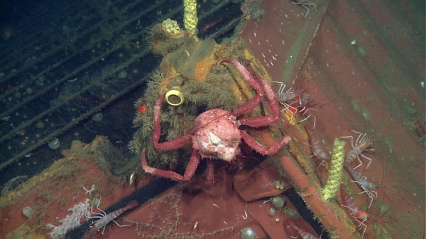
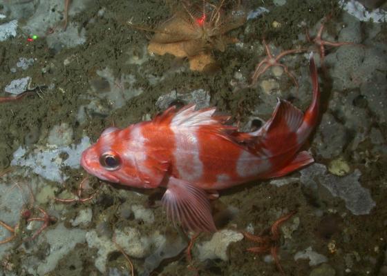
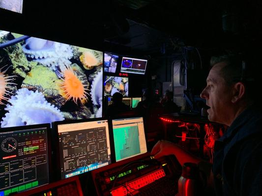
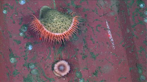
Photos
Maps
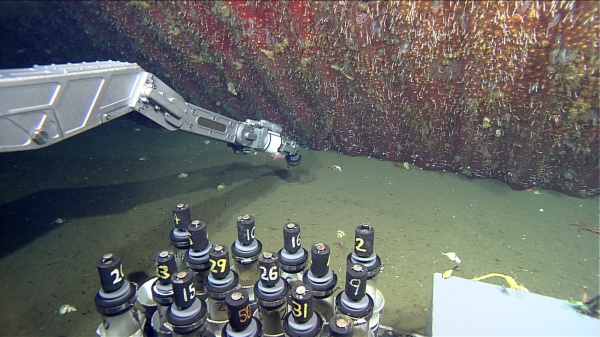
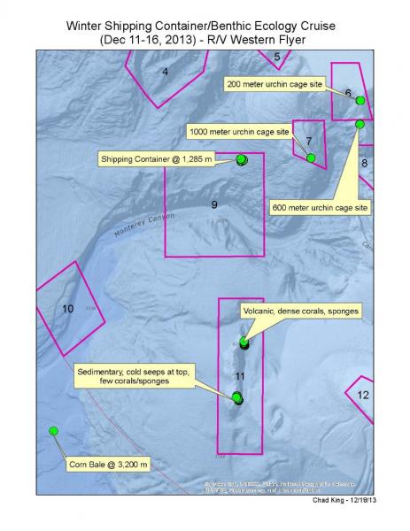
Winter Shipping Container/Benthic Ecology Cruise (Dec 11-16, 2013) Study Sites
[View Larger]
Deep Sea (Depth Zone Area by Sanctuary)
[View Larger]
ROV Dives on Sur Ridge Through August 2016
[View Larger]
California Seamounts
[View Larger]
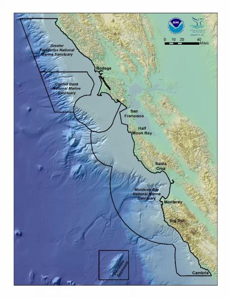
National Marine Sanctuaries of Central California
[View Larger]
Projects
Abyssal Fauna Associated With a Whale Fall in Monterey Canyon
On Feb 6, 2002 using the ROV Tiburon, we discovered an unusual deep-sea community associated with the remarkably well-preserved carcass of a gray whale (Eschrichtius robustus) at 2,891 m depth in the axis of Monterey Canyon.Archival of Midwater and Benthic Survey Data at Moss Landing Marine Laboratories
Since the early 1970s, faculty and students in Marine Ecology, Invertebrate Zoology, and Ichthyology courses at Moss Landing Marine Laboratories (MLML) have participated in class cruises aboard several research vessels to survey the fishes and invertebrates in shallow-benthic, deep-benthic and midwater habitats in Monterey Bay.California Cooperative Oceanic Fisheries Investigations (CalCOFI)
The California Cooperative Oceanic Fisheries Investigations (CalCOFI) was formed in 1949 to study the ecological aspects of the Pacific sardine population collapse off California. Today, the focus has shifted to the study of the marine environment off the coast of California, the management of its living resources, and monitoring the indicators of El Nino and climate change.
Davidson Seamount: 2002 Expedition
The Davidson Seamount is an impressive geologic feature located 120 km southwest of Monterey, California. This inactive volcano is roughly 2,300 m tall and 40 km long, yet its summit is far below the ocean surface (1,250 m). In May 2002, a diverse group of scientists led by the Monterey Bay National Marine Sanctuary embarked on an exploration to more fully characterize the Davidson Seamount.Davidson Seamount: 2006 Expedition to Ancient Coral Gardens
Building off the successes of an Office of Ocean Exploration (OE) expedition to Davidson Seamount in 2002, this project focused on deep-water corals. The week-long expedition in 2002 was the initial effort to characterize the biology and geology of the Davidson Seamount, 1,250 – 3,700 meters deep off Central California.Deepwater Characterization and Baseline Monitoring in the Monterey Bay National Marine Sanctuary
This project characterizes seafloor communities in the deeper waters of the MBNMS, including fish, macrofaunal invertebrates, and seafloor habitats. Baseline data are collected that can serve as the foundation for future monitoring efforts.Ecological Assessment of a Lost Shipping Container in the MBNMS
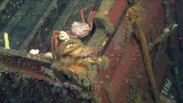
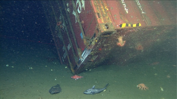
In February 2004, the cargo ship M/V Med Taipei encountered a storm and lost fifteen 40-ft shipping containers in MBNMS, and another nine south of the sanctuary. The Monterey Bay Aquarium Research Institute (MBARI) discovered one of these containers in June 2004 at a depth of 1,281 meters on Smooth Ridge, 17.5 nm NW of Point Pinos. This monitoring project describes the March 2011 and December 2013 research cruises to study the impacts, natural habitat recovery rate, and decomposition rate/characteristics of this submerged container.
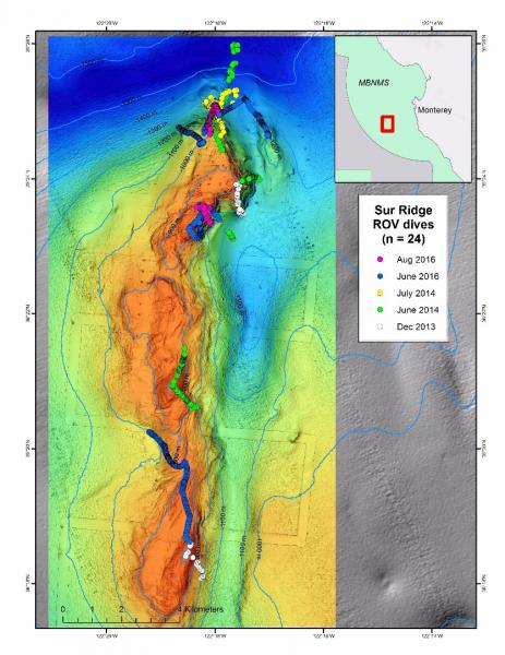
Exploration of Sur Ridge
Exploration of Sur Ridge began December 15, 2013 during a larger research cruise to revisit a lost shipping container. The surprising discoveries of that cruise led to subsequent exploration.Long-term Monitoring of Groundfishes in the Monterey Bay National Marine Sanctuary
Because many populations of fish and invertebrates are declining, we are developing a long-term monitoring plan to assess changes of benthic fishes and macroinvertebrates in the in the Monterey Bay National Marine Sanctuary. Initially we conducted submersible to survey groundfishes in selected deep rocky continental shelf and slope habitats of the sanctuary.Marine Protected Area Monitoring and Shelf Characterization in Monterey Bay National Marine Sanctuary
This project will assess the functionality of the Sanctuary's towed camera sled for collecting data on seafloor habitats and associated communities in the Monterey Bay National Marine Sanctuary.Passive acoustic (sound) monitoring: hydrophone use by MBARI
The marine 'soundscape' is a continuously changing mosaic of sounds that originate from living organisms (communication and foraging), non-living natural processes (breaking waves, rain) and human activities (shipping, construction, and resource extraction). Listening to sound in the sea is a rich exploration of the marine environment, which includes some of the ways in which human activities may intersect with marine life.
Pattern and Dynamics of Benthic Soft Sediment Faunal Communities
The objectives of this project are to determine the patterns of abundance of marine megafaunal populations on the continental shelf and slope to 1000 m depth in Monterey Bay, and measure changes in abundance over time.Population Dynamics of Sessile Deep-sea Invertebrates in Monterey Bay
The objectives of this study are to determine the rates of survival and reproduction of common benthic invertebrate megafauna that inhabit the continental slope in Monterey Bay.Potential Impacts of the Monterey Accelerated Research System (MARS) Cable on the Seabed and Benthic Faunal Assemblages
To assess the condition of the MARS cable and its potential effects on seabed geology and biology, several assessments were performed (2004, 2007-2008 and 2010). The most recent study was concluded 37 months after the cable was installed.Survey of deep-water coral and sponge habitats along the West Coast of the US using a remotely operated vehicle
Remotely operated vehicle surveys were conducted from a NOAA ship (the FSV Bell M. Shimada) during a six‐day transit November 1‐5, 2010 between San Diego, CA and Seattle, WA. The objective was to locate and characterize deep‐sea coral and sponge ecosystems at several recommended sites in and adjacent to NOAA sanctuaries.Links
American Museum of Natural History - Explore the Deep Oceans
Deep Sea teacher resources and curriculum for grades 6 and up. Topics include: Explore the Deep Ocean, How Deep Is Deep?, Under Pressure, and Dispatch from the Deep.http://www.amnh.org/education/resources/dsv/explore.php
Discovering Hidden Habitats: MBARI & NOAA
Join NOAA and the Monterey Bay Aquarium Research Institute's (MBARI) 2002 expedition to the deep trenches of the Monterey canyon where they discovered previously unknown species.http://www.youtube.com/watch?feature=player_embedded&v=jVrugjn79XY#!
Eisenhower National Clearinghouse: Deep Sea Missions
This video and lesson guide is one of a series whose purpose is to demonstrate the applicability of mathematics to real careers. Deep Sea Missions follows James McFarlane in his duties as chief Remotely Operated Vehicle pilot for the Monterey Bay Aquarium Research Institute. Students join McFarlane as he takes Mary Silver, a professor of marine biology, to the ocean floor to collect fragile marine samples.http://www.enc.org/resources/records/0,1240,003647,00.shtm
MBARI - Cold Seeps
Learn about the benthic communities that are linked to the seepage of methane and sulfide rich fluids from the ocean floorhttp://www.mbari.org/benthic/coldseeps.htm
MBARI - Current Research Projects
Learn about current research projects conducted by the Monterey Bay Aquarium Research Institute (MBARI).http://www.mbari.org/rd/projects/current_projects.html
MBARI - Deep Sea Benthic Invertebrate Guide
Find digital images of small organisms (macrofauna) collected in sediment core samples taken between 200 - 3600 m near Monterey Bay, California by the Monterey Bay Aquarium Research Institute (MBARI).http://www.mbari.org/benthic/fauna.html
MBARI - Deep-Sea Guide
A web-based system that allows for the correlation of visual, descriptive, and observational data with environmental data from multiple sources by providing tools for searching, identifying, and examining occurrence data (e.g., depth, time, abundance) for biological, geological, and experimental observations.http://dsg.mbari.org/
MBARI video of trash in the deep sea
Monterey Bay Aquarium Research Institute shares video of trash observed during deep sea missions with their ROV.http://www.youtube.com/watch?v=mOZngsJU2k0
Monterey Bay Aquarium - Mission to the Deep
Learn more about the fascinating world of the deep sea.http://www.montereybayaquarium.org/efc/efc_mbari/mbari_home.aspx?bhcp=1
Monterey Bay Aquarium - Student and Teacher Resources and Activities
The Monterey Bay Aquarium offers teacher and student resources including: species and habitat-specific information, live cams, classroom activities, and interactive online games.http://www.mbayaq.org/lc/
Monterey Bay National Marine Sanctuary - Cold Seep Communities
A comprehensive and educational scientific characterization of an important habitat in the Monterey Bay Sanctuary.http://montereybay.noaa.gov/sitechar/cold.html
Monterey Bay National Marine Sanctuary - Deeper Bottom Habitats
A comprehensive and educational scientific characterization of an important habitat in the Monterey Bay Sanctuary.http://montereybay.noaa.gov/sitechar/deep.html
NOAA - Ocean Exploration Lesson Plans
Students of all ages can learn about the oceans with near real-time access to a series of multidisciplinary deep ocean explorations. The site offers a set of over 100 hands-on and standards-based lesson plans for student exploration and discovery. Using new technological "eyes" to see, sense, measure, image, and describe a little known ocean world, these lessons bring the excitement of late-breaking ocean discoveries into classrooms.http://oceanexplorer.noaa.gov/explorations/06davidson/background/edu/lessonplans.html
NOAA - Ocean Explorer Program
Explore the ocean realm with NOAA. This Web site chronicles the adventures and discoveries of NOAA's at-sea science and education teams.http://oceanexplorer.noaa.gov/welcome.html
NOAA - Ocean Explorer Program
Explore the ocean realm with NOAA. This Web site chronicles the adventures and discoveries of NOAA's at-sea science and education teams.http://oceanexplorer.noaa.gov/
Ocean Explorer Gallery
Great resource for images and sounds. Collections include maps, living ocean, sound in the sea, cultural heritage, history, technology and explorers.http://www.oceanexplorer.noaa.gov/gallery/gallery.html
Project Oceanography - MBNMS
A University of South Florida distance-learning program for middle school students taught by scientific experts. "Unit II: Monterey Bay National Marine Sanctuary" contains teacher packets on various topics.http://www.marine.usf.edu/pjocean/packets/sp02/sp02.htm
The Pacific Shark Research Center (PSRC) at Moss Landing Marine Laboratories
The PSRC at MLML conducts both basic and applied scientific research on the biology of Pacific Ocean chondrichthyans, serves as a resource center for scientific information on sharks to public policy makers, and participates in collaborative research on national and international issues involving shark, ray, and chimaera biology.http://psrc.mlml.calstate.edu/
University of Delaware - Voyage to the Deep
Learn about an expedition to the deep sea and what scientists found there.http://www.ocean.udel.edu/deepsea