Overview
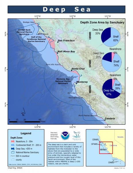
The deep sea is a dark, cold environment that includes a variety of habitats from the mid-water region to the abyss; these habitats are populated by a wide array of animals that are specially adapted to live under the tremendous water pressure and low oxygen level of this harsh environment. In recent years, improved sampling techniques and technologies have shown that the diversity of deep-sea fauna is greater than once thought.
The deep-sea environment includes depths greater than 200 meters (650 feet) – the approximate depth of the continental shelf break and the beginning of the continental slope.
The deep sea encompasses two distinct pelagic zones:
- The mesopelagic zone starts 200 meters below the surface and extends to about 1,000 meters.
- The bathypelagic zone starts below 1,000 meters and extends to the seafloor.
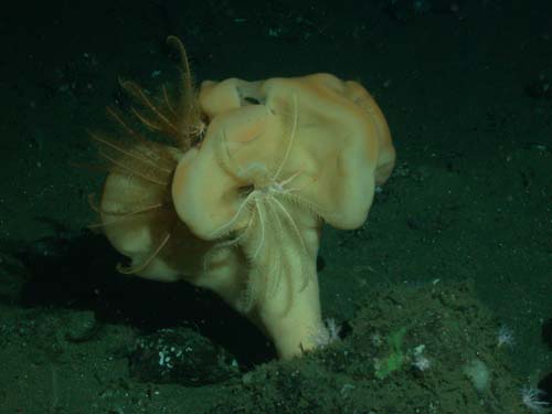
Most of the deep-sea areas of the sanctuary are likely made up of soft substrates. Nevertheless, it is possible that rocky outcropping habitats exist within this region. In other areas, these hard-bottom habitats, which provide more relief than the surrounding soft-bottom areas, have been found to be suitable seafloor features for unique and sensitive species, such as deep-water corals and sponges. These biogenic habitats, in turn, provide suitable habitat for various fish and invertebrate communities.
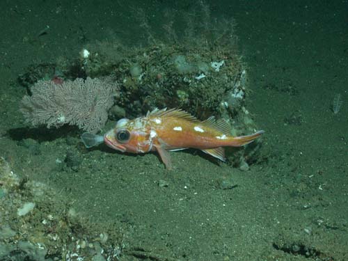
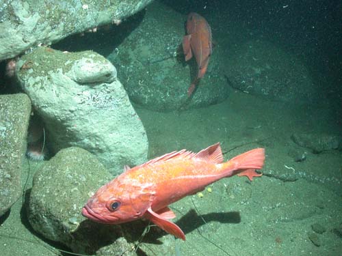
Rock outcrops on the shallow margins of the continental slope (depths of less than 300 meters) are infrequently encountered during submersible surveys. The relief and structure of these isolated features provide important habitat for a variety of groundfishes. Despite the small area and patchy nature of these rocky outcrops, high densities of canary rockfish, yelloweye rockfish, yellowtail rockfish, bocaccio and ling cod can be observed in close proximity to these features. The community rapidly changes back to a soft-bottom assemblage with distance from the rocky feature.
Although by volume the deep sea encompasses 98 percent of all living space on the planet, it is among the least understood ecosystems because of the challenges of accessing this remote environment. Marine scientists claim that we know more about space than we do about the deep sea.
To reach the deep sea, scientists require a platform from which to deploy sampling or observational gear. Today, in addition to net sampling, manned and unmanned research submersibles are deployed from research ships to collect remote data and make observations.
Little is known about the deep-sea region within this sanctuary; however, several submersible dives have been conducted on the upper slope between 200 and 300 meters. These dives have yielded some interesting observations, including a high diversity of fishes as well as the presence of Humboldt squid.
Fishes observed on the mud substrate of this habitat include spotted ratfish, poachers, English sole, slender sole, stripetail rockfish, splitnosed rockfish, long-spined combfish, hagfish grotto and six-gilled shark. Humboldt squid, which have previously occupied a range with a northern extent at southern California, were observed within the upper continental slope habitat (depths of 250 to 300 meters) of the sanctuary in 2005. Aggregations of the fragile pink sea urchin are commonly observed on the mud bottom of the upper slope.
Conservation and management issues affecting sanctuary resources in the deep sea include marine debris, seabed disturbance and non-sustainable fishing.
Anything that is discarded or washed into the sea may eventually end up in the deep sea. Marine debris is a worldwide problem, and deep-sea communities can be negatively impacted by what we do on shore.
Bottom trawling is widely believed to have negative impacts on benthic habitats; these include modification of the substrate, disturbance of soft-bottom communities and removal of non-target fish species. The structure of entire seafloor communities is at risk from repeated disturbance due to this fishing method. Currently we have an incomplete picture about the extent of these impacts in the sanctuary, but the use of trawl gear is an ongoing source of concern.
In June 2006, the Pacific Fishery Management Council and National Oceanic and Atmospheric Administration (NOAA) Fisheries closed large portions of the continental slope to trawling to protect essential fish habitat (EFH) for groundfishes. This included 212 square kilometers within the western-most portion of the sanctuary. In addition, trawl rockfish conservation areas (RCAs), which are depth-related closures, have been put in place to help rebuild depleted rockfish populations.
Monitoring
Benthic Community Characterization and Monitoring
The Cordell Bank National Marine Sanctuary, in partnership with the NOAA Fisheries Laboratory in Santa Cruz, the U.S. Geologic Survey, California Academy of Sciences and the California Department of Fish and Game, has conducted a study to classify habitats and monitor fishes and macro-invertebrates on and around Cordell Bank. Benthic transects were monitored annually from 2002 to 2005. The sanctuary plans to continue the monitoring program in the future; however, this is dependent upon funding levels.
Underwater surveys of fishes, invertebrates and their habitats were conducted on and around Cordell Bank using direct observation and video-transect methods from an occupied research submersible (Delta). Transects were distributed over the bank to sample all bank habitats and associated biota.
The data provided the sanctuary staff with a species inventory of fishes and benthic invertebrates. Long-term data may be used to identify habitat affinities for species complexes, develop habitat suitability models and provide a foundation to evaluate change over time.
West Coast Deep Sea Coral Assessment
In 2010 as part of the NOAA Coral Reef Conservation Program, NOAA-led surveys of deep sea corals and sponges and their associated communities were conducted from Washington to southern California, including sampling in Cordell Bank National Marine Sanctuary (CBNMS). The cruise in CBNMS focused on target locations with a high likelihood of corals based on habitat maps from multibeam sonar seafloor data. Daytime operations consisted of ROV (remotely operated vehicle) surveys and nighttime operations consisted of CTD casts and water sampling focused on obtaining baseline data that could be used to assess ocean acidification and to help understand habitat features influencing coral distribution patterns.
Direct observations were made using an ROV on the continental slope just west of Cordell Bank at depths between 180 and 500m. High-definition video and still images were collected using the ROV. In addition to biological observations, the video and still images from the ROV provide data for ground truthing habitat maps created from multibeam data. One goal of this effort is to contribute information to the Pacific Fishery Management Council for management of existing or future Essential Fish Habitat (EFH) Conservation Areas.
West Coast Bottom-Trawl Survey
The NOAA Fisheries Northwest Fisheries Science Center (NWFSC) conducts annual bottom-trawl surveys of U.S. West Coast groundfish resources. These surveys are designed to provide resource managers with fishery-independent data about the distribution, abundance and biological characteristics of commercially important fish species, particularly Pacific hake, sablefish, and many of the shelf and slope rockfish species.
Survey methodology has changed somewhat since the initiation of studies by the NOAA Fisheries Alaska Fisheries Science Center (AFSC), which conducted studies triennially from 1977 until 2001. Currently, NWFSC conducts annual surveys from the Canadian border to the Mexican border, using chartered commercial fishing vessels towing standardized nets. Separate shelf (55 to 500 meters) and slope (183 to 1,280 meters) surveys are performed.
Photos
Maps
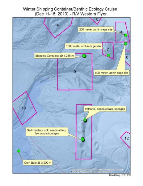
Winter Shipping Container/Benthic Ecology Cruise (Dec 11-16, 2013) Study Sites
[View Larger]
Deep Sea (Depth Zone Area by Sanctuary)
[View Larger]
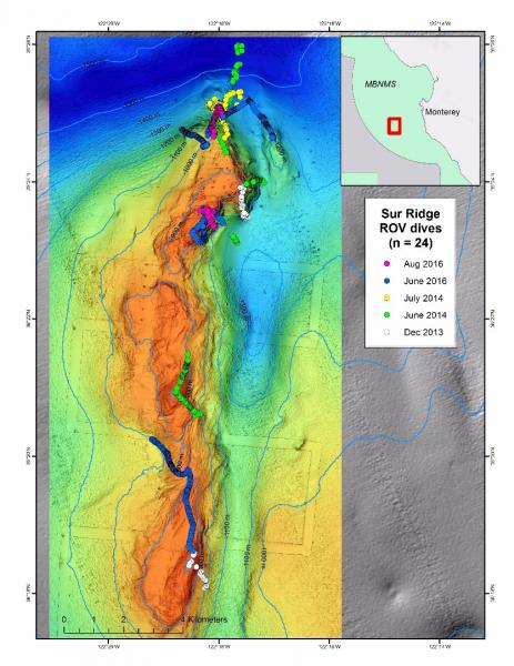
ROV Dives on Sur Ridge Through August 2016
[View Larger]
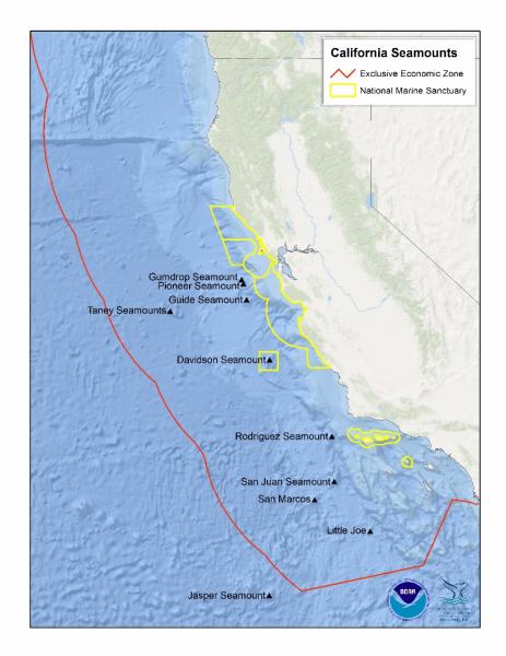
California Seamounts
[View Larger]
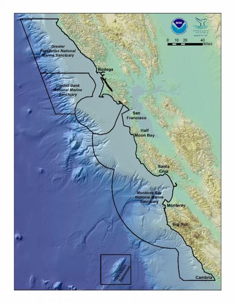
National Marine Sanctuaries of Central California
[View Larger]
Projects
California Cooperative Oceanic Fisheries Investigations (CalCOFI)
The California Cooperative Oceanic Fisheries Investigations (CalCOFI) was formed in 1949 to study the ecological aspects of the Pacific sardine population collapse off California. Today, the focus has shifted to the study of the marine environment off the coast of California, the management of its living resources, and monitoring the indicators of El Nino and climate change.
Cordell Bank Habitat Characterization and Biological Monitoring
In 2002, sanctuary staff and collaborators initiated a program to quantify the diversity, distribution and abundance of habitats, fishes and invertebrates on and around Cordell Bank and follow these parameters over time. Underwater surveys of macrofauna (fish and invertebrates) and habitats are conducted using direct observation and video transects from an occupied submersible (Delta).NOAA's Deep-Sea Coral FY2010 Assessment for the U.S. West Coast
The marine region off the coast of Washington, Oregon and California accounts for about 7% (778,628 km2) of the total area of the U.S. Economic Exclusive Zone and contains extensive deep-sea coral (DSC) communities. NOAA manages five National Marine Sanctuaries (NMS) on the West Coast: the Channel Islands (CINMS), Monterey Bay (MBNMS), Gulf of the Farallones (GFNMS), Cordell Bank CBNMS), and Olympic Coast (OCNMS). All contain deep-sea corals.Links
American Museum of Natural History - Explore the Deep Oceans
Deep Sea teacher resources and curriculum for grades 6 and up. Topics include: Explore the Deep Ocean, How Deep Is Deep?, Under Pressure, and Dispatch from the Deep.http://www.amnh.org/education/resources/dsv/explore.php
Discovering Hidden Habitats: MBARI & NOAA
Join NOAA and the Monterey Bay Aquarium Research Institute's (MBARI) 2002 expedition to the deep trenches of the Monterey canyon where they discovered previously unknown species.http://www.youtube.com/watch?feature=player_embedded&v=jVrugjn79XY#!
Eisenhower National Clearinghouse: Deep Sea Missions
This video and lesson guide is one of a series whose purpose is to demonstrate the applicability of mathematics to real careers. Deep Sea Missions follows James McFarlane in his duties as chief Remotely Operated Vehicle pilot for the Monterey Bay Aquarium Research Institute. Students join McFarlane as he takes Mary Silver, a professor of marine biology, to the ocean floor to collect fragile marine samples.http://www.enc.org/resources/records/0,1240,003647,00.shtm
MBARI - Cold Seeps
Learn about the benthic communities that are linked to the seepage of methane and sulfide rich fluids from the ocean floorhttp://www.mbari.org/benthic/coldseeps.htm
MBARI - Current Research Projects
Learn about current research projects conducted by the Monterey Bay Aquarium Research Institute (MBARI).http://www.mbari.org/rd/projects/current_projects.html
MBARI - Deep Sea Benthic Invertebrate Guide
Find digital images of small organisms (macrofauna) collected in sediment core samples taken between 200 - 3600 m near Monterey Bay, California by the Monterey Bay Aquarium Research Institute (MBARI).http://www.mbari.org/benthic/fauna.html
MBARI - Deep-Sea Guide
A web-based system that allows for the correlation of visual, descriptive, and observational data with environmental data from multiple sources by providing tools for searching, identifying, and examining occurrence data (e.g., depth, time, abundance) for biological, geological, and experimental observations.http://dsg.mbari.org/
MBARI video of trash in the deep sea
Monterey Bay Aquarium Research Institute shares video of trash observed during deep sea missions with their ROV.http://www.youtube.com/watch?v=mOZngsJU2k0
Monterey Bay Aquarium - Mission to the Deep
Learn more about the fascinating world of the deep sea.http://www.montereybayaquarium.org/efc/efc_mbari/mbari_home.aspx?bhcp=1
Monterey Bay Aquarium - Student and Teacher Resources and Activities
The Monterey Bay Aquarium offers teacher and student resources including: species and habitat-specific information, live cams, classroom activities, and interactive online games.http://www.mbayaq.org/lc/
Monterey Bay National Marine Sanctuary - Cold Seep Communities
A comprehensive and educational scientific characterization of an important habitat in the Monterey Bay Sanctuary.http://montereybay.noaa.gov/sitechar/cold.html
Monterey Bay National Marine Sanctuary - Deeper Bottom Habitats
A comprehensive and educational scientific characterization of an important habitat in the Monterey Bay Sanctuary.http://montereybay.noaa.gov/sitechar/deep.html
NOAA - Ocean Exploration Lesson Plans
Students of all ages can learn about the oceans with near real-time access to a series of multidisciplinary deep ocean explorations. The site offers a set of over 100 hands-on and standards-based lesson plans for student exploration and discovery. Using new technological "eyes" to see, sense, measure, image, and describe a little known ocean world, these lessons bring the excitement of late-breaking ocean discoveries into classrooms.http://oceanexplorer.noaa.gov/explorations/06davidson/background/edu/lessonplans.html
NOAA - Ocean Explorer Program
Explore the ocean realm with NOAA. This Web site chronicles the adventures and discoveries of NOAA's at-sea science and education teams.http://oceanexplorer.noaa.gov/welcome.html
NOAA - Ocean Explorer Program
Explore the ocean realm with NOAA. This Web site chronicles the adventures and discoveries of NOAA's at-sea science and education teams.http://oceanexplorer.noaa.gov/
Ocean Explorer Gallery
Great resource for images and sounds. Collections include maps, living ocean, sound in the sea, cultural heritage, history, technology and explorers.http://www.oceanexplorer.noaa.gov/gallery/gallery.html
Project Oceanography - MBNMS
A University of South Florida distance-learning program for middle school students taught by scientific experts. "Unit II: Monterey Bay National Marine Sanctuary" contains teacher packets on various topics.http://www.marine.usf.edu/pjocean/packets/sp02/sp02.htm
The Pacific Shark Research Center (PSRC) at Moss Landing Marine Laboratories
The PSRC at MLML conducts both basic and applied scientific research on the biology of Pacific Ocean chondrichthyans, serves as a resource center for scientific information on sharks to public policy makers, and participates in collaborative research on national and international issues involving shark, ray, and chimaera biology.http://psrc.mlml.calstate.edu/
University of Delaware - Voyage to the Deep
Learn about an expedition to the deep sea and what scientists found there.http://www.ocean.udel.edu/deepsea