Overview
Cordell Bank National Marine Sanctuary provides habitat for a wealth of biological diversity. Every organism that resides within or moves through the sanctuary depends upon clean water, as do all our commercial and recreational uses.
The sanctuary is far enough offshore to be relatively free of any direct impacts associated with terrestrial inputs. As a result, it is thought that water quality within the sanctuary is relatively good.
The sanctuary’s eastern edge is located 10 kilometers (6.2 miles) from shore and is adjacent to Marin and Sonoma Counties, which are sparsely populated and rural in character. About 80 kilometers to the southeast is the major San Francisco-Oakland metropolitan area, with a population of about 8 million people.
The San Francisco Bay plume, a trail of fresh water that extends out through the Golden Gate, is typically pushed to the south and away from the sanctuary. The plume from the Russian River, which is located 21 kilometers from the sanctuary boundary, may enter the sanctuary in spring, but typically this flow is inshore of Cordell Bank. Due to depth, resuspension of bottom sediments is not thought to substantially affect sanctuary resources.
Water quality within the sanctuary may vary seasonally, due to precipitation and current patterns. For instance, San Francisco Bay water may intrude into the sanctuary during peak runoff in the winter, when ocean currents flow to the north.
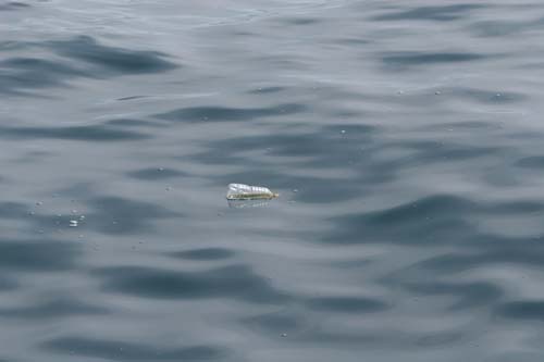
As an example, in January 2006, researchers on a pelagic monitoring cruise observed impacts at Cordell Bank from the severe flooding of coastal counties due to heavy rainfall. Debris such as large logs, dock pilings, floats, bottles, balloons, plastic sheets and bags littered the surface waters over Cordell Bank – all likely originating from San Francisco Bay. This event was an indicator that extended El Niño conditions with heavy rains could affect water quality at Cordell Bank sanctuary as water and debris from San Francisco Bay intrude into the sanctuary.
There is no evidence of eutrophication or harmful algal blooms (HABs) within the sanctuary. Chlorophyll levels spanning seven years (1997 to 2004) have been summarized, and it does not appear that chlorophyll levels in the sanctuary during this time approached values that would indicate eutrophication.
Monthly estimates of chlorophyll-a in recent years (2004 to the present) demonstrate similar patterns. In addition, water samples are taken from the sanctuary during monthly monitoring cruises for the California Department of Health Services. The goal is to identify early warning signs of HABs, focusing on the dinoflagellate Alexandrium catenella (which causes paralytic shellfish poisoning) and the diatom Pseudonitzschia spp (domoic acid carriers). To date, there have been no indications of elevated levels of either species.
There is a threat to sanctuary water quality from an accidental oil spill or other discharges from vessels, particularly if a catastrophic spill were to occur from a larger vessel. The northern shipping lane for commercial vessels going into and out of San Francisco Bay terminates within the sanctuary, and an average of 2,000 commercial vessel transits take place each year through this lane. Also, over 100 cruise ships transits into and out of San Francisco Bay each year, with a portion of these passing through the sanctuary heading to or coming from the Pacific Northwest or Alaska. Accidental spills are reported to the USCG’s National Response Center. Most routine, operational vessel discharges allowed by law are not tracked, however.
Oceanographic conditions can influence the impact of an oil spill on the marine environment, affecting the dispersal and accumulation of oil. For example, convergent fronts have been shown to capture oil slicks and influence their movement and dispersion. Thus, fronts could potentially increase the probability of wildlife coming in contact with oil and consuming contaminated prey within the offshore environment.
Monitoring
Cordell Bank Ocean Monitoring Program
The Cordell Bank Ocean Monitoring Program (CBOMP) collected information on the spatial and temporal variability in the oceanographic system of the Cordell Bank region from 2004 to 2010. Data on the abundance of seabirds, marine mammals, other vertebrates and marine debris were collected by trained observers along six 12-kilometer east-west transects centered on Cordell Bank. Physical and biological characteristics of the pelagic system were measured along transects using a CTD (vertical profiles of salinity, temperature, chlorophyll-a, and light levels at set stations), TSG (continuous surface values of salinity, temperature, chlorophyll-a) and echo sounder (continuous measurements of relative abundance of zooplankton).
Starting in 2010, CBOMP was replaced by the Applied California Current Ecosystem Studies (ACCESS) program.
Marine Biotoxin Monitoring and Control Program
The sanctuary collects samples during the monthly ocean monitoring program (CBOMP) that contribute to the Marine Biotoxin Monitoring and Control Program – a state-wide effort, managed by the California Department of Health Services, that involves a consortium of volunteer participants.
This program is designed to detect toxin-producing species of phytoplankton in ocean water before they harm the public. The phytoplankton monitoring and observation effort can provide an advanced warning of a potential toxic bloom, allowing agencies to focus sampling efforts in the affected area before California’s valuable shellfish resources or the public health are threatened.
Cordell Bank Oceanographic Buoy
The Cordell Bank buoy was deployed in the spring of 2007, through a collaboration between University of California-Bodega Marine Laboratory and Cordell Bank National Marine Sanctuary. The system is comprised of sensors for water velocity, water temperature, salinity, turbidity, chlorophyll fluorescence and wind velocity.
The mooring is located at a depth of 85 meters on the northern part of Cordell Bank, about 20 nautical miles west of Point Reyes. This buoy provides near-real-time data that are linked with regional coastal ocean observing systems and are used by sanctuary staff, research oceanographers and local communities to understand offshore ocean conditions better. Further, over time, this mooring will provide an invaluable record of fluctuations and change in the ocean environment that supports the highly productive marine ecosystem in this region.
Photos
Maps
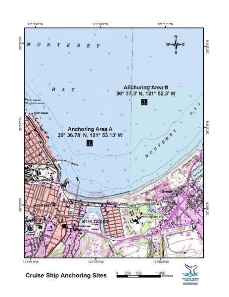
Cruise Ship Anchoring Sites
[View Larger]
Projects
California Cooperative Oceanic Fisheries Investigations (CalCOFI)
The California Cooperative Oceanic Fisheries Investigations (CalCOFI) was formed in 1949 to study the ecological aspects of the Pacific sardine population collapse off California. Today, the focus has shifted to the study of the marine environment off the coast of California, the management of its living resources, and monitoring the indicators of El Nino and climate change.
Cordell Bank Ocean Monitoring Program
The goal of the Cordell Bank Ocean Monitoring Program (CBOMP) is to characterize and monitor the spatial and temporal variability in the physical and biological components of the pelagic ecosystem in the region surrounding Cordell Bank. In addition, these data can be integrated with regional ocean observing programs to understand changes in the central California ocean environment. Monthly cruises (sometimes seasonally) were conducted from 2004-2010.Links
Adopt–A-Watershed
This curriculum is designed for K-12 students and is available for purchase. Topics include: What is a Watershed, Streamside Community, Wade into Watersheds, Water Quality, and Watershed Physics.http://www.adopt-a-watershed.org
Bilingual MERITO Web Site
The English/Spanish MERITO (Multicultural Education for Resource Issues Threatening Oceans) website provides bilingual information on: MERITO programs, dates of upcoming events, background information on a variety of sanctuary issues, downloadable education materials, and current reports and documents related to MERITO.http://www.montereybay.noaa.gov/educate/merito/welcome.html
California Coastal Commission - Waves, Wetlands, and Watersheds Activity Guide
This classroom and community activity guide addresses issues such as endangered species, marine debris, coastal geology, water use, and much more. It is carefully aligned to the California State Science Content Standards for grades 3 through 8, and includes "Community Action" lessons adaptable for all ages up to and beyond grade 12. Available for free.http://www.coastal.ca.gov/publiced/pendx.html
Center for Highly Interactive Computing in Education: hi-ce
A comprehensive Great Lakes based curriculum that is very adaptable to other regions, for middle school grades.http://hice.org/index.html
Central Coast Water Quality Data Synthesis, Assessment and Management (SAM) Project
The SAM Project facilitates region-wide water quality monitoring coordination, data management, and data analysis for addressing the sources, status, and trends of non-point source (NPS) pollution on the Central Coast via technical, scientific, and programmatic activities. Key goals of the project include enhancement of the regional water quality monitoring network and improving access to information used for managing coastal watershed and nearshore marine systems. SAM is a partnership between the Monterey Bay National Marine Sanctuary, the State and Regional Water Quality Control Boards, and the Central Coast Wetlands Group.http://www.ccamp.net/sam/index.php/Main_Page
Central Coast Watershed Studies (CCoWS)
The Central Coast Watershed Studies (CCoWS) team is part of the Watershed Institute, in the Division of Science and Environmental Policy at California State University Monterey Bay. They conduct research on watersheds that feed into the MBNMS.http://ccows.csumb.edu/home/
Coastal Watershed Council
The Coastal Watershed Council is a nonprofit organization committed to the preservation, protection and management of coastal watersheds through establishment of community-based watershed stewardship programs, education and community outreach.http://www.coastal-watershed.org
Elkhorn Slough Water Quality and Weather Monitoring
Learn how two different programs are involvoed in monitoring water quality in the Elkhorn Slough.http://www.elkhornslough.org/research/waterquality_main.htm
First Flush
The Monterey Bay National Marine Sanctuary and the Coastal Watershed Council released a report indicating that storm water is not clean.http://www.publicaffairs.noaa.gov/releases2003/apr03/noaa03r412.html
GLOBE
GLOBE is a worldwide hands-on, primary and secondary school-based education and science program for students and teachers led by a Federal interagency program supported by NASA, NSF, EPA and the U.S. State Department. Students take scientifically valid measurements, report their data through the Internet, analyze data sets, and collaborate with scientists and other GLOBE students around the world.http://www.globe.gov
Monterey Bay Aquarium - Student and Teacher Resources and Activities
The Monterey Bay Aquarium offers teacher and student resources including: species and habitat-specific information, live cams, classroom activities, and interactive online games.http://www.mbayaq.org/lc/
Monterey Bay Sanctuary Citizens Watershed Monitoring Network
The Monterey Bay Sanctuary Citizen Watershed Monitoring Network is a consortium of approximately twenty citizen monitoring groups that monitor the health of the watersheds flowing into the Monterey Bay National Marine Sanctuary. It was established in 1997 and has since provided support, training, and a central forum and database for citizen monitoring programs. The Network also coordinates two annual regional monitoring events, First Flush in the fall and Snapshot Day in the spring.http://www.montereybay.noaa.gov/monitoringnetwork/welcome.html
My Water Quality
Access interactive maps and monitoring data that focus on chemical contaminants and biotoxins in fish and shellfish that may affect the health of human consumers.http://www.waterboards.ca.gov/mywaterquality/
NOS Education Discovery Kits
Discovery Kits describe the basic scientific principles underlying the applied science and activities of NOAA's National Ocean Service (NOS). Designed for educators and students at the high school level, they are written in easy-to-read, non-technical language, and focus on the themes of oceans, coasts, and charting and navigation.http://oceanservice.noaa.gov/education/kits/welcome.html
Overview of Harmful Algal Blooms (HABs)
See how National Centers for Coastal Ocean Science (NCCOS) is acting to respond to the growing threat of harmful algal blooms, which can devastate local economies as well as pose a risk to human health.http://www.cop.noaa.gov/stressors/extremeevents/hab/default.aspx
Project WET
Project Wet is an international, interdisciplinary, water education program for formal and non-formal educators of students ages 5 to 18. Available for purchase only.http://www.projectwet.org/
Santa Cruz Surfrider Foundation - Seawater Testing
The Santa Cruz Chapter of the Surfrider Foundation monitors water quality by testing the presence of bacteria at several locations weekly.http://www.surfridersantacruz.org/
U.S. Environmental Protection Agency - Marine Debris Curriculum
A learning guide entitled "Turning the Tide on Trash" that explains marine debris for grades 3-6 and includes three online units with definitions and activities.http://www.epa.gov/owow/OCPD/Marine/contents.html
U.S. Environmental Protection Agency - Teacher Resources
Need activity ideas for your unit on water quality? Interested in teaching pollution prevention concepts? This site offers curricula, activities and creative ways to teach your students about the environment.http://www.epa.gov/teachers/