Overview
The continental shelf is the gradually sloping submerged margin of the continent that extends from the nearshore to the shelf break. Beyond the shelf break (at a depth of approximately 200 meters, or 650 feet), the continental slope descends more steeply to the ocean floor. It can be subdivided according to depth, including:
- the intertidal (salt spray to extreme low water)
- shallow subtidal (0 to 30 meters)
- outer shelf (30 to 200 meters)
The outer continental shelf is the focus of this section. For shelf areas shallower than 30 meters, see Rocky Shores, Kelp Forests, Beaches and Sandy Floor.
In the Monterey Bay National Marine Sanctuary, the outer continental shelf is relatively broad from the northern boundary to southern Monterey Bay. The shelf narrows considerably south of Monterey Bay and remains narrow throughout most of the southern portion of the sanctuary, except around Point Sur and near the southern boundary.
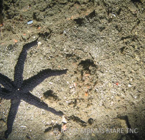
A large portion of the shelf in the sanctuary is composed of soft-bottom habitats, which cover approximately 3,584 square kilometers (1,384 square miles) from depths of 30 to 200 meters. Sandy bottom is generally found in shallow waters of the shelf (less than 40 meters). The percentage of mud, silt and clay increases as depth increases on the shelf and beyond the shelf break. The lack of hard substratum for attachment prevents algae and some invertebrates from colonizing soft-bottom habitats.
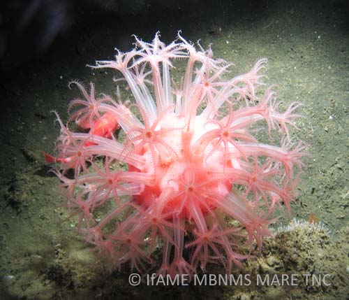
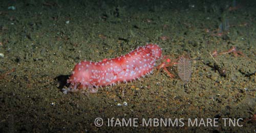
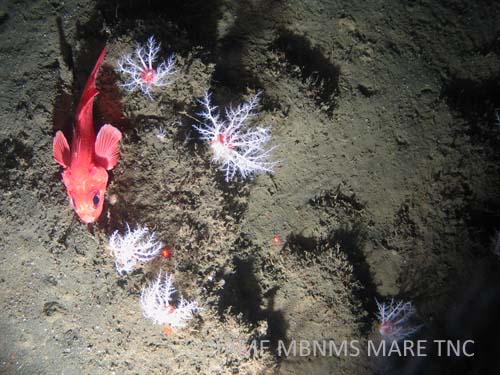
Soft-bottom associated species live either on the surface of, or buried in, the sediments. Some of these animals, such as the burrowing tube anemone, build somewhat permanent tubes and burrows. The burrowing activities of fishes and invertebrates help to mix the surface sediments and also add some structural relief to a relatively flat habitat. Occasional rock outcrops, in an otherwise soft-bottom habitat, provide substrate for large sessile, sedentary and habitat-forming invertebrates, including white-plumed anemones, crinoids and basket stars (image).
The rocky habitat that speckles the seafloor between the edge of the kelp forest and the continental shelf break (30 to 200 meters) covers approximately 249 square kilometers – only 1.8 percent of the seafloor in the sanctuary. Rock outcrops below 30 meters are teeming with life. Small forms of brown and red algae grow on rock outcrops down to a depth of between 60 and 75 meters (off Point Sur), depending on the clarity of the water. Sessile invertebrates cover the rocky bottom, forming a biogenic habitat that supplies food and shelter to many mobile invertebrate and fish species.
The complex physical structure created by boulders, caves, pinnacles and outcrops is a favorite habitat of many rockfish species. Pelagic predators, including seabirds and marine mammals, hunt for fishes and invertebrate prey along the benthos.
Much less is known about the shelf than is known about coastal kelp forests and sandy floor (0 to 30 meters) because most researchers using SCUBA equipment are limited to waters less than 30 meters deep. Conversely, remotely operated vehicles (ROVs) and other new technologies used to study deep-sea habitats tend to be used in waters deeper than 200 meters.
However, exploration and monitoring of this habitat is occurring in the sanctuary. For example, current studies of benthic habitat characterization and species abundance and distribution on the shelf rely on technology such as side scan sonar, camera sleds and manned submersibles. (See examples in “Monitoring,” below.)
Conservation
Conservation and management issues affecting sanctuary resources on the shelf include seabed disturbance, non-sustainable fishing and cable-laying.
Bottom trawling is a concern related to the first two of these issues: it can have negative impacts on benthic habitats, such as modification of the substratum, disturbance of soft-bottom communities and removal of non-target fish species. In fact, the structure of entire seafloor communities is at risk from this fishery practice.
Currently, there is an incomplete picture about the extent of trawling’s impacts in the sanctuary, but the use of trawl gear is an ongoing source of concern. In general, trawling is not allowed in state waters (mean high tide line to three nautical miles offshore). In addition, trawl rockfish conservation areas (RCAs) are closures (approximately 183 to 274 meters deep, in the sanctuary) to minimize bycatch of overfished rockfishes. RCA boundaries, however, may change during the year.
Scientists also want to understand the potential impacts on the sanctuary benthos from cable-laying. See below for details of a project that monitors the Acoustic Thermometry of Ocean Climate (ATOC)/Pioneer Seamount cable.
Monitoring
Seafloor Mapping in Monterey Bay, Cordell Bank and Greater Farallones National Marine Sanctuaries
In April 2004, scientists from the National Oceanic and Atmospheric Administration (NOAA) and the U.S. Geological Survey conducted a 21-day research cruise aboard the NOAA Ship McArthur II. This study was one of the most extensive efforts to date to document the seafloor of the continental shelf in the three central California national marine sanctuaries.
Researchers mapped approximately 480 kilometers of the seafloor with side scan sonar and collected underwater video over approximately 200 kilometers to characterize the habitat types and diversity and the benthic assemblages of sea life on the continental shelf; including a first look at many areas. Results from this seafloor mapping study provide valuable characterization of sanctuary biology and geology that is useful as a foundation for management of the national marine sanctuaries.
Long-Term Monitoring of Groundfishes in the Sanctuary
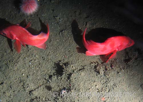
In 2004, scientists from California Sea Grant, California Academy of Sciences, NOAA Fisheries, Moss Landing Marine Laboratories and the sanctuary surveyed deep, rocky continental shelf habitats to characterize, monitor and assess long-term changes in benthic fishes and associated habitats. They conducted 131 visual strip transects aboard the submersible Delta to compare groundfish abundance, size and diversity off Monterey Peninsula and Point Sur from 70 to 120 meters.
Overall species diversity, abundance and sizes were greater off Point Sur than off the Monterey Peninsula. Off the Monterey Peninsula, the shallower (70 to 90 meters) high-relief rocky areas had lower species diversity than the deeper (90 to 120 meters) low-relief areas. They also revisited sites off Monterey Peninsula that were surveyed in 1993 and compared abundance, species-habitat relationships, and species and size composition. Species composition was relatively similar. Mean lengths of all rockfishes were greater in 2004 than in 1993, except for yellowtail rockfish, Sebastes flavidus, and squarespot rockfish, Sebastes hopkinsi.
Demersal Habitats and Deep-Water Fishes on the Continental Shelf off Davenport
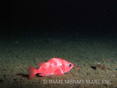
In 2004, scientists from NOAA Fisheries surveyed demersal fishes and habitats using the submersible Delta on the continental shelf off Davenport in depths between 60 and 100 meters. Their objectives were to characterize shelf habitats, assess fish diversity and evaluate habitat-fish associations. They surveyed 112 transects (two meters wide and 10 minutes in duration) over a distance of 32 kilometers.
Habitat complexity ranged from low-relief mud to complex boulder habitats. The dominant habitats were mud, boulder, cobble and brachiopod beds, of which mud was the most abundant (50 percent of the habitats). Most of the 12,371 fishes (52 species) were rockfishes (genus Sebastes) representing 68 percent of all fishes. The most common fish species were pygmy, rosy, greenspotted, yellowtail, and greenstriped rockfishes and black-eyed gobies. Work will continue to monitor these shelf habitats off Davenport.
Deep-Water Habitat and Fishes Associated with Big Creek Marine Ecological Reserve
Baseline information on species-habitat relationships, density, and species and size composition of fishes inside and outside the Big Creek Marine Ecological Reserve (BCER) was collected in the fall of 1997 and 1998 by scientists from NOAA Fisheries, Moss Landing Marine Laboratories, California Department of Fish and Game and California Sea Grant. They surveyed 142 video transects using the submersible Delta at depths of 20 to 250 meters.
The researchers identified more than 70,000 fishes from 82 taxa, including 36 rockfish species. Young-of-the-year rockfishes dominated rock outcrops in 20- to 90-meter depths inside and outside the BCER. Four distinct fish assemblages were associated with different habitat types. Fish density was greater in high-relief rock habitats than in low-relief soft and mixed sediments, regardless of location. The investigators recommended the development of a monitoring program to continue surveys after increased time of protection.
Habitat Characterization
A camera sled video survey [by whom? when?] on the sanctuary shelf resulted in a habitat characterization describing differences in habitat associations:
- Sand-wave habitats were occupied by sand dabs and often contained schools of juvenile rockfishes.
- Sediment-ripple habitats were commonly occupied by white brittle stars buried within the sediment.
- Low-lying cobble beds were often occupied by encrusting sponges, gorgonians and half-banded rockfishes.
- High-relief bedrock habitats, although less common on the mid- to outer-shelf, were occupied by encrusting invertebrates, vase sponges, large anemones, gorgonians and many rockfish species.
Acoustic Thermometry of Ocean Climate (ATOC)/Pioneer Seamount Cable
To better understand the potential impacts of the Acoustic Thermometry of Ocean Climate (ATOC)/Pioneer Seamount cable on the benthos, scientists from the Monterey Bay Aquarium Research Institute and the sanctuary surveyed areas along the cable route, from the nearshore origin to the cable terminus at Pioneer Seamount.
Wave action along the nearshore (20 meters) route of the cable caused cable strumming and consequent incision of rocky siltstone outcrops. In addition, frayed cable at the 43-meter station probably resulted from seafloor abrasion during high-energy events. Intense trawling activity in the area is another possible cause of damage to the cable.
There were few effects of the ATOC/Pioneer Seamount cable on epifaunal or infaunal organisms from the continental shelf to the deep sea. Anemones were significantly more abundant in sediment-dominated areas (75, 140, 240, 950 meters) where the cable was exposed on the seafloor (providing a substratum for attachment) than at control stations. Fishes at the 43- and 75-meter stations were significantly more abundant near the cable than at the control, probably a result of increased shelter caused by the cable at these stations.
Trends in Fisheries and Fishery Resources
A great number of commercial and recreational fisheries occur on and above the continental shelf. A recent study by scientists at California Sea Grant and Moss Landing Marine Laboratories summarized trends in fisheries and fishery resources associated with the sanctuary from 1981 to 2000. Some fished populations found on the shelf are declining and new regulations have been put in place. For more information, see Fishes.
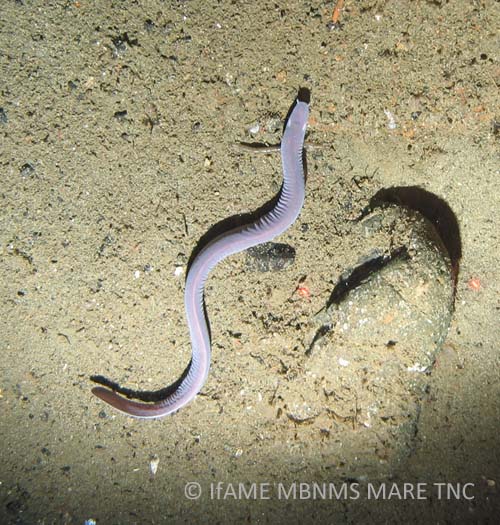
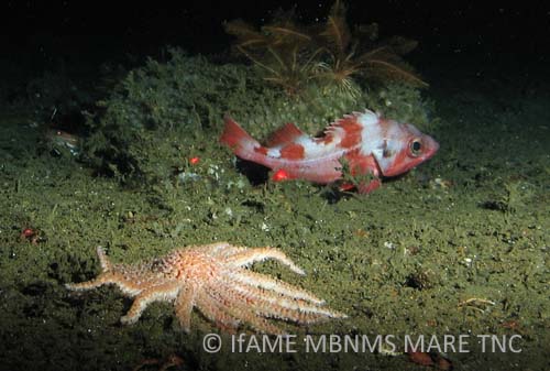
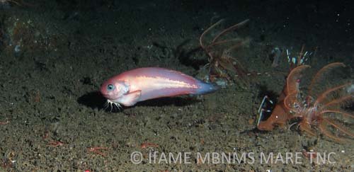
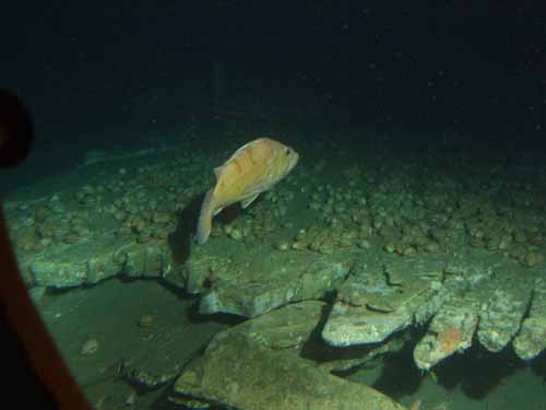
Photos
Maps
F/V McArthur II Cruise Video Sled Tracklines - April 2004
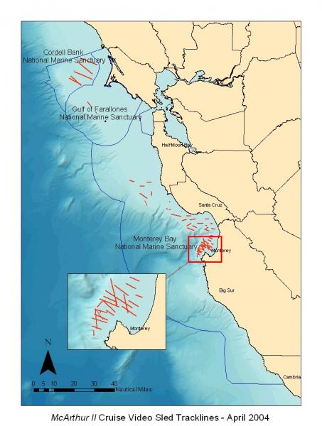
[View Larger]
National Marine Sanctuaries of Central California
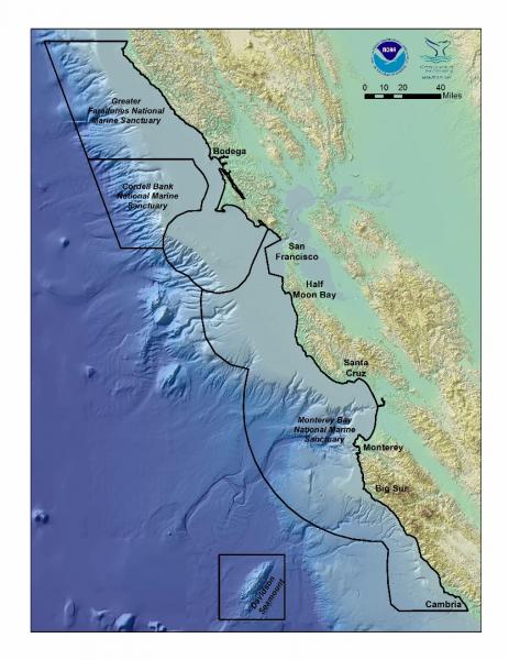
[View Larger]
Projects
Central coast trawl impact and recovery project: a collaborative fisheries study
This is the first controlled study on the west coast of the US to study the effects of bottom trawling on habitat and community structure.
Deepwater Characterization and Baseline Monitoring in the Monterey Bay National Marine Sanctuary
This project characterizes seafloor communities in the deeper waters of the MBNMS, including fish, macrofaunal invertebrates, and seafloor habitats. Baseline data are collected that can serve as the foundation for future monitoring efforts.Ecological Assessment of a Lost Shipping Container in the MBNMS
In February 2004, the cargo ship M/V Med Taipei encountered a storm and lost fifteen 40-ft shipping containers in MBNMS, and another nine south of the sanctuary. The Monterey Bay Aquarium Research Institute (MBARI) discovered one of these containers in June 2004 at a depth of 1,281 meters on Smooth Ridge, 17.5 nm NW of Point Pinos. This monitoring project describes the March 2011 and December 2013 research cruises to study the impacts, natural habitat recovery rate, and decomposition rate/characteristics of this submerged container.
Marine Protected Area Monitoring and Shelf Characterization in Monterey Bay National Marine Sanctuary
This project will assess the functionality of the Sanctuary's towed camera sled for collecting data on seafloor habitats and associated communities in the Monterey Bay National Marine Sanctuary.Multibeam bathymetry mapping of priority habitat areas with the Monterey Bay National Marine Sanctuary
The goal of this project was to provide high-resolution multibeam bathymetry and sonar-derived habitat GIS products for several of the priority mapping areas primarily along the central coast of California from Yankee Point (near Carmel) to the southern MBNMS boundary (near Cambria) at depths <80 m.Northern Central California Coast State Waters Mapping Project (NCCMP)
This project maps the state water seafloor habitats (MHHW out to 3 nm) from Año Nuevo to Bolinas (NCCMP Phase I) using bathymetric LIDAR and multibeam echo sounders (MBES) to obtain both bathymetry data and acoustic backscatter and reflectance imagery.Population Dynamics of Sessile Deep-sea Invertebrates in Monterey Bay
The objectives of this study are to determine the rates of survival and reproduction of common benthic invertebrate megafauna that inhabit the continental slope in Monterey Bay.Seafloor Mapping in Monterey Bay, Cordell Bank, and Gulf of the Farallones National Marine Sanctuaries
National Oceanic and Atmospheric Administration and U.S. Geological Survey scientists mapped and characterized seafloor areas on the continental shelf in three west coast National Marine Sanctuaries using side-scan sonar and underwater video technology.usSEABED: A USGS Pacific Coast Offshore Surficial Sediment Data and Mapping Project
The USGS will soon publish its first release of Pacific coast data from the usSEABED database, a map-based compilation of offshore surficial sediment data.Links
Bureau of Ocean Energy Management
BOEM is leading the nation toward a renewable energy future. We have issued the first-ever lease for offshore commercial wind energy development.http://www.boem.gov/
ONR Description of the Continental Shelf
Office of Naval Research description of ocean zones, including continental shelf.http://www.onr.navy.mil/Focus/ocean/regions/oceanfloor2.htm
UNEP Shelf Program
Information on data, rights of coastal states, and workshops revolving around continental shelf research.http://www.continentalshelf.org/