Overview
Submarine canyons are the most prominent geomorphic features within the Monterey Bay National Marine Sanctuary.
Monterey Canyon, in the center of Monterey Bay, is the largest submarine canyon along the coast of North America. Similar in size to the Grand Canyon in Arizona, it is 470 kilometers (292 miles) long and approximately 12 kilometers at its widest point, with a maximum rim to floor relief of 1,700 meters (5,577 feet). The Monterey Canyon system includes two additional canyon heads, Soquel Canyon and Carmel Canyon, which flank Monterey Canyon to the north and south, respectively.
Numerous smaller canyons, including Pioneer, Ascension, Año Nuevo, Cabrillo, Sur, Partington, Lucia, Villa and La Cruz, cut into the continental shelf and slope of the sanctuary. The walls and floors of submarine canyons cover approximately 2,175 square kilometers, or 16 percent, of the sanctuary seafloor. The great majority of canyon habitat is soft-bottom; a much smaller portion is hard-bottom.
Much of the sediment carried by longshore currents ends up in the axes of active submarine canyons. It is estimated that approximately 500,000 cubic meters (17,657,333 cubic feet) of sand as well as large volumes of finer-grained material descend into Monterey Canyon each year.
Lucia Canyon, the major submarine canyon in the southern portion of the sanctuary, and its many heads act as funnels for the rapid transport of detritus eroded from the Santa Lucia Mountains to the deep abyssal plain. Submarine landslides from canyon walls also deposit sediments on the canyon floor. The organic material associated with sediments provides nutrients to deep-sea organisms.
Submarine canyon sediment transport events are thought to be episodic. Potential triggering events include storms, earthquakes, moderate sea and surf conditions, tidal fluctuation, and flooding rivers. The frequency of these events is not well known. Current monitoring efforts, including repeat bathymetric mapping and installation of instruments in the canyons, enable scientists to determine locations where deposition and erosion take place and to quantify the frequency and intensity of sediment transport events.
Most organisms observed in canyons are not unique to canyon systems but are also found at similar depths outsides canyons. However, because submarine canyons extend from shallow waters of the continental shelf to the deep sea and contain a wide range of habitats, they contain an incredible diversity of organisms.
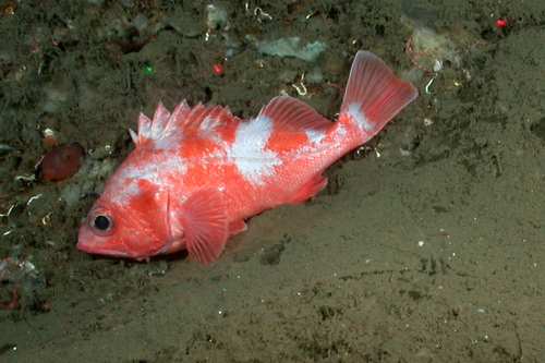
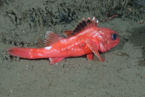
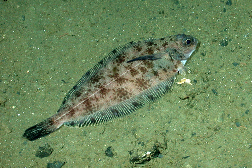
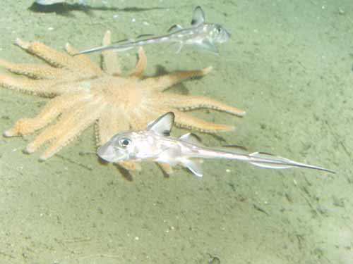
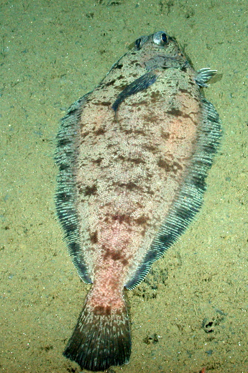
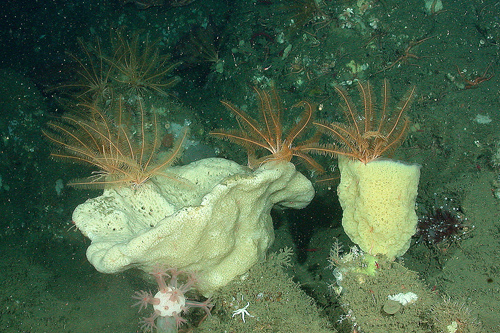
Mobile fishes and invertebrates, such as prickly sharks and krill, have been found to aggregate in canyon heads and along canyon walls. Rocky outcrops along canyon walls are colonized by invertebrates – including feather stars, corals and tunicates – and provide shelter for a variety of rockfishes. Clams and worms burrow into canyon walls. The soft sediments on the canyon floor support a diverse community of invertebrates (e.g., sea pens, sea cucumbers, brittle stars, sea stars) and fishes (e.g., flatfishes, ratfishes, whiptails, grenadiers, sablefish, hake, thornyheads).
Submarine canyons are vulnerable to a variety of human activities because they extend across a range of depths. A comparison of contaminant loads in surface and deep-sea fishes in Monterey Bay found elevated concentrations of persistent organic pollutants, such as PCBs and DDT, in fishes collected from the Monterey Submarine Canyon.
The risk of pollutant bioaccumulation is higher in submarine canyons than in surrounding waters because the flow of sediments and pollutants tends to be concentrated in canyons. These processes may also lead to an accumulation of marine debris, such as abandoned fishing gear, plastics and other man-made items, in canyons.
One important sanctuary management issue relating to submarine canyons revolves around whether to allow installation of communication cables – and if so, where to place them. If routed across submarine canyons, the cables may break as sediments rush down these geologic features. In addition, loops from slack cables are potential entanglement hazards for mobile species, such as marine mammals.
Monitoring
The proximity of canyons to the shore in the sanctuary provides scientists with a unique opportunity to study canyon habitats. Recent monitoring efforts have focused on sediment movement events, mapping of benthic habitats, and determining the abundance and distribution of fishes and invertebrates. These programs tend to use in-situ instrumentation to study sediment movements and manned or remotely operated submersibles to study the distribution and abundance of habitats and organisms.
Gravity Flow Event in Monterey Canyon
Instruments deployed to monitor sediment deposition and movement rates in the Monterey Submarine Canyon detected a large sediment gravity flow event on December 20, 2001. Using information on the deployment and recovery locations of the instruments, Monterey Bay Aquarium Research Institute (MBARI) scientists determined that the event likely started in less than 290 meters of water.
After the event, a sediment core collected from the axis of the canyon at a depth of 1,297 meters contained fresh, greenish chlorophyll-rich organic material – suggesting that the event extended to at least this depth in the canyon. The only trigger identified for this mass movement event appeared to be moderate sea and surf conditions.
In-Situ Measurements of Turbidity Currents in the Monterey Submarine Canyon
In a 2002-2003 study by the United States Geological Survey and the Naval Postgraduate School, the first-ever in-situ measurements of velocity profiles of four turbidity currents were recorded. Maximum along-canyon velocity reached 190 centimeters per second, which is equivalent to 4.25 miles per hour. The turbidity events all occurred in winter. Two of these turbidity currents appeared to be related to storms and another was likely human-induced.
Deep-Water Demersal Fishes and Habitats
Benthic groundfishes (primarily rockfishes in the genus Sebastes) and associated habitats in deep water were assessed in Soquel Submarine Canyon. At least 52 species were identified from 83 transects in 1992-1993 and from 26 transects in 2002-2003. The most abundant taxa observed during this study included poachers, Pacific hagfish, Pacific hake, Dover sole, lingcod, shortspine thornyhead and rockfishes. Distinct habitat guilds of fishes were identified.
Small species were associated with mud and cobble substrates of low relief, whereas larger species of rockfishes were on high-relief structures such as vertical rock walls, ridges and boulder fields. The cover and protection offered by submarine canyons appear to allow pockets of rockfish populations to flourish, in contrast to more exposed areas, where the populations are more easily fished.
Demersal Fishes in Ascension and Partington Canyons
Researchers created habitat maps of the headward parts of Ascension and Partington Canyons using MBARI multibeam bathymetric and backscatter data, processed to five-meter grid resolution, and newly collected side scan sonar data. Seafloor features depicted on the habitat maps were ground truthed, and fish assemblages were surveyed using the Delta submersible along 50-meter depth contours between 200 and 350 meters in Ascension Canyon and at 75, 150, 250 and 350 meters in Partington Canyon.
In Ascension Canyon, 2,839 fishes from at least 47 species, including 21 rockfish species, were reported among 32 transects conducted in 2001. The stripetail rockfish, Sebastes saxicola, was the dominant fish species at 200 and 250 meters, whereas flatfishes (e.g., Glyptocephalus zachirus, Microstomus pacificus) were dominant at 300 and 350 meters. Species diversity was greatest at 300 and 350 meters and was significantly greater on the south side of the canyon than on the north side, probably because of more varied habitat types in the former region.
In Partington Canyon, 3,389 fishes representing 48 species, including 27 rockfish species, were documented from 16 transects conducted in 2003. Rockfishes were dominant at all depths, but species distribution varied with depth. Species diversity was greatest at 250 meters in this region. Habitat associations of dominant fishes were determined in each location.
Photos


Maps
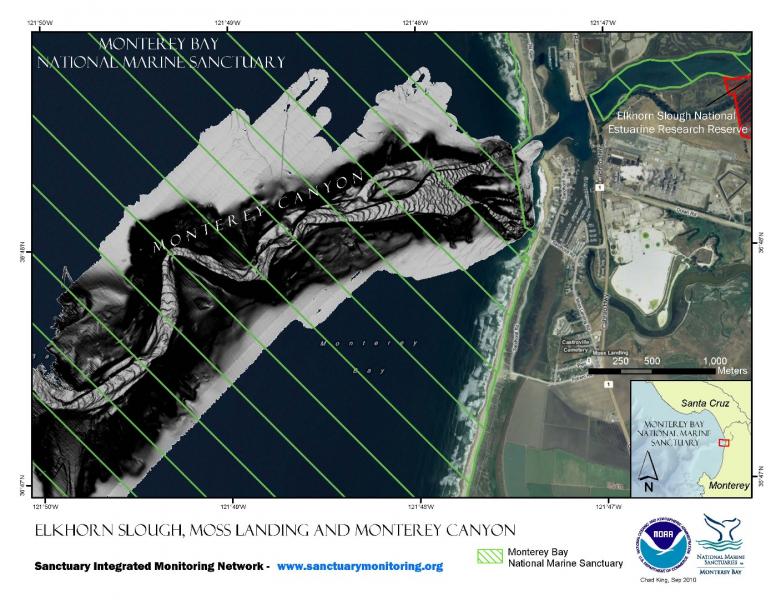
Elkhorn Slough, Moss Landing and Monterey Canyon
[View Larger]
Projects
Deepwater Characterization and Baseline Monitoring in the Monterey Bay National Marine Sanctuary
This project characterizes seafloor communities in the deeper waters of the MBNMS, including fish, macrofaunal invertebrates, and seafloor habitats. Baseline data are collected that can serve as the foundation for future monitoring efforts.Deepwater Demersal Fishes and Habitats
This is an assessment of benthic groundfishes (primarily of rockfishes in the genus Sebastes) and associated habitats in deep water conducted in Soquel Submarine Canyon, Monterey Bay, California.Gravity Flow Event in Monterey Canyon, 20 December 2001
A sediment gravity flow descended through Monterey Canyon on December 20, 2001. The timing of this event is documented by a current meter found 550 m down-canyon from its deployment site, buried completely within a thick deposit of sediment.In-situ Measurements of Turbidity Currents in the Monterey Submarine Canyon
For the first-time, scientists direclty measured the speed and character of turbidity currents in Monterey Canyon.Long-term Monitoring of Groundfishes in the Monterey Bay National Marine Sanctuary
Because many populations of fish and invertebrates are declining, we are developing a long-term monitoring plan to assess changes of benthic fishes and macroinvertebrates in the in the Monterey Bay National Marine Sanctuary. Initially we conducted submersible to survey groundfishes in selected deep rocky continental shelf and slope habitats of the sanctuary.Multibeam bathymetry mapping of priority habitat areas with the Monterey Bay National Marine Sanctuary
The goal of this project was to provide high-resolution multibeam bathymetry and sonar-derived habitat GIS products for several of the priority mapping areas primarily along the central coast of California from Yankee Point (near Carmel) to the southern MBNMS boundary (near Cambria) at depths <80 m.Northern Central California Coast State Waters Mapping Project (NCCMP)
This project maps the state water seafloor habitats (MHHW out to 3 nm) from Año Nuevo to Bolinas (NCCMP Phase I) using bathymetric LIDAR and multibeam echo sounders (MBES) to obtain both bathymetry data and acoustic backscatter and reflectance imagery.Survey of deep-water coral and sponge habitats along the West Coast of the US using a remotely operated vehicle
Remotely operated vehicle surveys were conducted from a NOAA ship (the FSV Bell M. Shimada) during a six‐day transit November 1‐5, 2010 between San Diego, CA and Seattle, WA. The objective was to locate and characterize deep‐sea coral and sponge ecosystems at several recommended sites in and adjacent to NOAA sanctuaries.Links
MBARI - Current Research Projects
Learn about current research projects conducted by the Monterey Bay Aquarium Research Institute (MBARI).http://www.mbari.org/rd/projects/current_projects.html
MBARI - Deep-Sea Guide
A web-based system that allows for the correlation of visual, descriptive, and observational data with environmental data from multiple sources by providing tools for searching, identifying, and examining occurrence data (e.g., depth, time, abundance) for biological, geological, and experimental observations.http://dsg.mbari.org/
MBARI - Mapping the Monterey Canyon
See how the Monterey Bay Aquarium Research Institute (MBARI) is involved in mapping the seafloor of the Monterey Bay National Marine Sanctuary.http://www.mbari.org/canyon/Mapping_Sections.htm
MBARI - Vessels and Vehicles
Take a closer look at some of the Monterey Bay Aquarium Research Institute's (MBARI) vessels and vehicles that allow scientists to get a closer look at the deep sea.http://www.mbari.org/data/images_video/vessels_vehicles.htm
MBNMS Teacher Curriculum - The Land-Sea Connection
Teacher activity "The Land-Sea Connection": Conducting a Transect Along the Seafloor of the Monterey Bay National Marine Sanctuary, takes students in for a close look at the Sanctuary's benthic region. After becoming familiar with a bathymetric/topographic map of the area, students select a transect along the seafloor to study some of the geological, biological, and physical features that are present. Available in both Spanish and English.http://montereybay.nos.noaa.gov/educate/teachercurriculum/investigation2.html
Monterey Bay Aquarium - Mission to the Deep
Learn more about the fascinating world of the deep sea.http://www.montereybayaquarium.org/efc/efc_mbari/mbari_home.aspx?bhcp=1
Monterey Bay Aquarium - Student and Teacher Resources and Activities
The Monterey Bay Aquarium offers teacher and student resources including: species and habitat-specific information, live cams, classroom activities, and interactive online games.http://www.mbayaq.org/lc/
National Geographic Society - Monterey Bay Sanctuary
Take a virtual dive into the kelp forest, or explore the submarine canyon in the Monterey Bay Sanctuary, one of the largest protected marine areas in the world.http://www.nationalgeographic.com/monterey/
National Geographic Society - Monterey Bay Sanctuary
Take a virtual dive into the kelp forest, or explore the submarine canyon in the Monterey Bay Sanctuary, one of the largest protected marine areas in the world.http://www.nationalgeographic.com/monterey/
NOAA - Ocean Exploration Lesson Plans
Students of all ages can learn about the oceans with near real-time access to a series of multidisciplinary deep ocean explorations. The site offers a set of over 100 hands-on and standards-based lesson plans for student exploration and discovery. Using new technological "eyes" to see, sense, measure, image, and describe a little known ocean world, these lessons bring the excitement of late-breaking ocean discoveries into classrooms.http://oceanexplorer.noaa.gov/explorations/06davidson/background/edu/lessonplans.html
UCSC Science Notes - AUV Dorado
Learn more about the Autonomous Underwater Vehicle (AUV) Dorado and its exciting capabilities in a University of California, Santa Cruz (UCSC) Science Notes online article.http://scicom.ucsc.edu/SciNotes/0201/lo/sub/
USGS - Monterey Bay Internet Map Server
Continental Shelf GIS for the Monterey Bay Area - selected data layers for the USGS seafloor for the Monterey Bay National Marine Sanctuary Project from USGS published reports and other sources.http://coastalmap.marine.usgs.gov/ArcIMS/website/usa/westcoast/cencal/montereybay/viewer.htm
USGS Pacific Coastal & Marine Science Center
Homepage of USGS Division that conducts multidisciplinary scientific research in the coastal and offshore areas of California, Oregon, Washington, Alaska, Hawaii, and other US Pacific Islands; and in other waterways of the United States.http://walrus.wr.usgs.gov
Virtual Descent into Monterey Submarine Canyon
Take a trip into the depths of the ocean and explore a place that scientists are just now beginning to study in great detail. During this presentation, you will be able to listen and read about each photograph in both English and Spanish!http://projects.edtech.sandi.net/projects/descent/Descent01.html