Overview
Beaches are one of the most visible and popular sanctuary habitats, representing half the intertidal habitat in Monterey Bay National Marine Sanctuary. Every year, travelers from around the world come to enjoy the natural scenery, wildlife and recreation that our beaches offer.
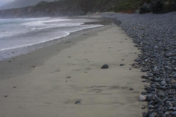
Beaches consist of unconsolidated material of varying sizes, most commonly sand, gravel or pebbles. Sand, for example, comes from the erosion of larger rocks both nearshore and far inland, created over long periods of time and transported to our shores by rivers, waves, winds and currents.
Beaches are constantly in flux, gaining and losing material daily and seasonally. When sand loss exceeds supply, the coast erodes. Coastal erosion poses a significant hazard in the state of California as the retreat of shorelines threatens coastal habitat and property. The Fort Ord area, for example, is experiencing some of the highest rates of erosion in the state of California.
The main process that moves sand is called “littoral drift” or “longshore drift”. See the following links from our partners for more information:
- What causes longshore drift?
- How do beaches form?
- What processes affect coastal change?
Beaches have many challenges – a few examples include issues related to water quality, coastal armoring, and trash.
- Water quality: Various agencies and citizen groups monitor the water quality of sanctuary beaches. These groups collect water samples and test for levels of coliform bacteria, which are indicators of contaminants that may cause sickness in humans. For more information visit our water quality page.
- Coastal armoring: Throughout the sanctuary, structures are installed to prevent the natural erosion of the coastline. This coastal armoring helps protect public and private property from destruction; however, it can potentially damage or alter local coastal habitats and deprive beaches of sand. Sand deprivation may cause a loss of beach and intertidal areas through a process termed “passive erosion.” The sanctuary, working with local agencies, has developed a draft management plan for this issue. Check out the link to the latest management plan.
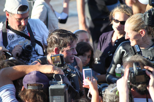
- Trash: Refuse is dumped overboard by ships at sea, carried by rivers and storm drains from inland areas, and deposited directly on beach areas by visitors. Regardless of its origin, much of this trash ends up on beaches and can pose a threat to seabirds, marine mammals and turtles. In the sanctuary region, many people volunteer their time to pick up beach litter. Since 1985, volunteers gather every year on the third Saturday of September for the California Coastal Cleanup Day event, to collect trash on beach areas up and down the state. Join the next one!
Monitoring
Long-term Monitoring Program & Experiential Training for Students (LiMPETS)
LiMPETS is a program for middle schools, high schools and other volunteer groups; it was developed to monitor rocky intertidal, sandy beach and offshore areas of the five West Coast national marine sanctuaries: Olympic Coast, Cordell Bank, Greater Farallones, Monterey Bay and Channel Islands.
The sanctuaries and their partners monitor the abundance and distribution of major intertidal biota, sand crabs and selected offshore species to increase awareness and stewardship of these ecosystems. Various data collection procedures include transects, random quadrat counts, total organism counts, sex determination and size measurements. Data are collected so that long-term changes can be followed by interested groups working with the sanctuaries’ education staff.
Sandy beach monitoring in the West Coast marine sanctuaries focuses on the Pacific mole crab, Emerita analoga, or sand crab – a common inhabitant. Sand crabs, which filter-feed plankton from the water, are important organisms in this ecosystem. They are eaten by coastal birds and sea otters.
Sand crabs are used by humans as bait for fishing and have been used as indicators of the pesticide DDT and the neurotoxin domoic acid. The sand crab is also an intermediate host for a number of parasites, including acanthocephalans (thorny-headed worms), which affect threatened sea otters and Surf Scoters.
The Interaction of Sea Walls and Beaches: Eight Years of Field Monitoring in Monterey Bay
Active erosion is one of three potential impacts from coastal protection structures. Gary Griggs (University of California Santa Cruz) investigated this potential impact by monitoring beaches adjacent to sea walls along the central California coast, biweekly to monthly during a seven-year period. These surveys allowed Griggs to evaluate both the seasonal beach changes due to the presence of sea walls as well as any longer-term effects.
Although active erosion during winter months was documented at sea walls in this study, erosion was seasonal and temporary in nature. A comparison of summer and winter beach profiles on beaches with sea walls and on adjacent control beaches revealed no significant long-term effects or impacts from sea walls in this location during this seven-year period.
Coastal Ocean Marine Mammal & Bird Education and Research Surveys (Beach COMBERS)
Since 1997, trained volunteers have surveyed beached marine birds and mammals monthly at selected beach sections throughout the Monterey Bay area as part of the Coastal Ocean Mammal and Bird Education and Research Surveys (Beach COMBERS) program.
Beach COMBERS is a collaborative effort between Moss Landing Marine Laboratories and the sanctuary, along with other state and research institutions including California Department of Fish and Game, Marine Wildlife Veterinary Care and Research Center, and the University of California Davis. The project uses deposition of beach-cast carcasses as an index of the sanctuary’s health.
This program has been very successful – by providing data for a number of scientific papers that contribute to the conservation of sanctuary resources as well as identifying and quantifying oiled wildlife, among many other accomplishments. For example:
- The program highlighted a sharp peak (during August and September, 1997) in Common Murre, Uria aalge, deposition – in contrast to relatively stable numbers leading into and following that period. This deposition event was attributed to an increase in fishing effort and bycatch of Common Murres in fishing nets at this time
- Presence of beach-cast pinnipeds exhibited a dramatic increase in June 1998 and remained high through September 1998. This was attributed to a toxic phytoplankton bloom (i.e., a domoic acid event).
- Trends in deposition are also related to the individual species’ specific susceptibility to mortality (e.g., many young Common Murres are deposited at the end of summer) and occurrence patterns in the area. Migratory species such as Loons, Grebes, Sea Ducks and Shearwaters exhibit peaks in mortality corresponding to the time they are most abundant in the bay.
- Chronic and major oil spillage continues to be a source of mortality for marine birds in the sanctuary.
Ecological Effects of the Moss Landing Thermal Discharge
From 2002 to 2005, scientists and students at Moss Landing Marine Laboratories determined if changes in the distribution or community structure of the benthic fauna could be correlated with the thermal plume from the Moss Landing Power Plant (MLPP) outfall; and compared beach fauna to a study done in 1975.
There were no detectable significant impacts of the MLPP outfall on intertidal and shallow subtidal faunal communities. There was no significant difference in the abundance of intertidal total fauna, crustaceans or polychaetes between 1975 to 1976 and 2003 to 2005. There were, however, significantly fewer species between 2003 and 2005.
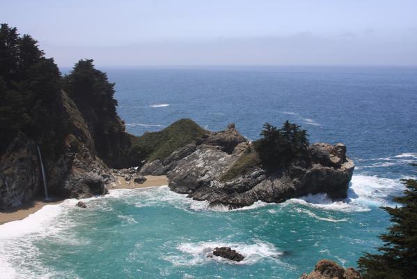
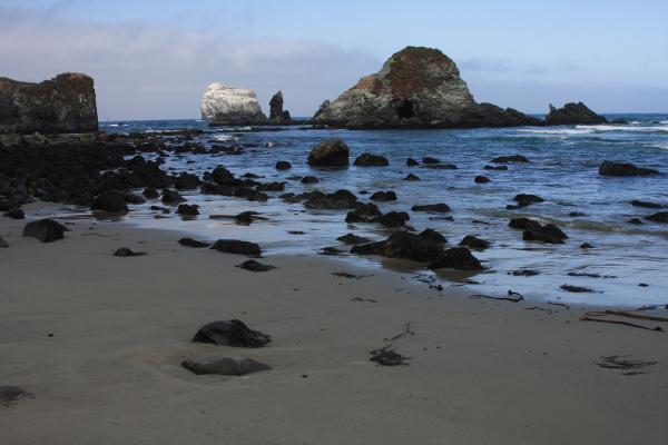
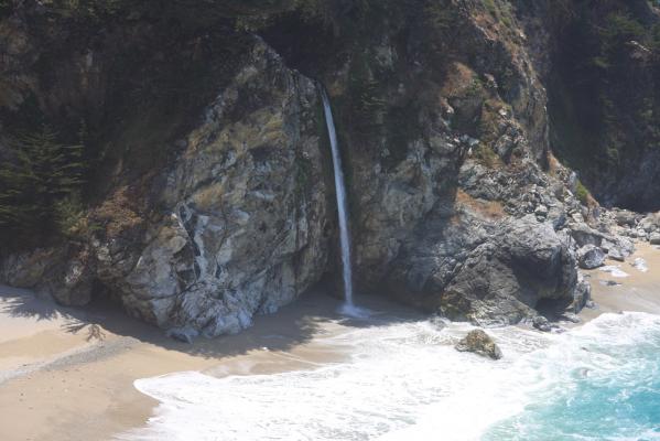
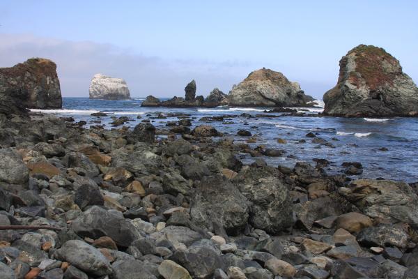
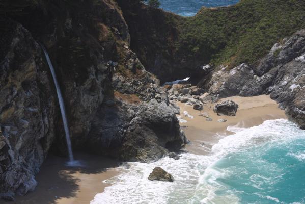
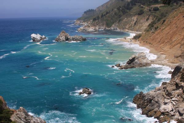
Photos

Maps
Shoreline type along the central California coastline
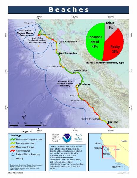
[View Larger]
Projects
Beach Watch
Beach Watch is a long-term, beach-monitoring project. Beaches surveyed stretch from Bodega Head in Sonoma County down to Año Nuevo in San Mateo County. Volunteers survey a designated beach segment counting, identifying, and photo-documenting live and dead birds and marine mammals and human activity on- and immediately offshore.Characterization of geologic and oceanographic conditions at Pleasure Point, Santa Cruz County
A USGS study is underway to characterize the coastal bluffs, inner shelf morphology and wave conditions at Pleasure Point in Santa Cruz County.Coastal Erosion Along the U.S. West Coast During the 1997-98 El Niño: Expectations and Observations
During late summer 1997, NASA's Wallops Flight Facility, NOAA's Coastal Services Center, and the USGS Coastal & Marine Program formulated a plan to determine the magnitude, spatial patterns, and causative processes of El Niño-induced change along the west coast of the United States.Coastal Ocean Mammal and Bird Education and Research Surveys (Beach COMBERS)
In 1997, we began a beach survey program called Coastal Ocean Mammal and Bird Education and Research Surveys (Beach COMBERS) using trained volunteers to survey beached marine birds and mammals monthly at selected sections of beaches from Wadell Creek to Morro Bay.Ecological Effects of the Moss Landing Thermal Discharge
This study was designed to provide a quantitative evaluation of the impacts of the thermal discharge into the Sanctuary from the Moss Landing Power Plant.Interaction of Seawalls and Beaches: Eight Years of Field Monitoring, Monterey Bay, California
A long-term investigation of how coastal armoring structures affect beach morphology, both seasonally and over many years.LiMPETS sandy beach monitoring
This page describes the monitoring program implemented by LiMPETS (Long-term Monitoring Program and Experiential Training for Students) in sandy beach habitats.Moss Landing Power Plant Post-modernization Thermal Plume Evaluation
A thermal plume evaluation study, which was designed to measure the distribution of heated waters discharged by the modernized Moss Landing Power Plant (MLPP), was conducted in compliance with Central Coast Regional Water Quality Control Board (RWQCB) permit and California Energy Commission (CEC) certification requirements.Oblique Aerial Photography - Coastal Erosion from El Niño Winter Storms
The U.S. Geological Survey as part of its Coastal and Marine Program is taking aerial photographs to assess coastal erosion from severe storms.Santa Cruz County Marine Debris Tracking
The goal of the Santa Cruz County Marine Debris Tracking project is to reduce the amount of debris reaching the Monterey Bay National Marine Sanctuary. Save Our Shore provides the community with opportunities to participate in debris prevention and debris removal. In addition, Save Our Shore strives to help people make the connection between their lifestyle choices and the collective community impacts of marine debris on our oceans.usSEABED: A USGS Pacific Coast Offshore Surficial Sediment Data and Mapping Project
The USGS will soon publish its first release of Pacific coast data from the usSEABED database, a map-based compilation of offshore surficial sediment data.Links
California Coastal Commission - 1995 ReCAP Pilot Project, Monterey Bay Region: Coastal Hazards
This chapter summarizes ReCAP's investigation of shoreline hazard response -- protection of upland development by armoring, the permitting associated with existing armoring, the impacts from armoring, the policies which address shoreline protection, and the likely changes which will happen to the shoreline in the future assuming existing trends and policies continue.http://www.coastal.ca.gov/recap/chap3.html
California Coastal Commission - Waves, Wetlands, and Watersheds Activity Guide
This classroom and community activity guide addresses issues such as endangered species, marine debris, coastal geology, water use, and much more. It is carefully aligned to the California State Science Content Standards for grades 3 through 8, and includes "Community Action" lessons adaptable for all ages up to and beyond grade 12. Available for free.http://www.coastal.ca.gov/publiced/pendx.html
California Geological Survey - An index to online geologic field trips, including coastal Central California
The California Geotour is an interactive index of Web pages of geologic field trip guides and related Web sites compiled by the California Geological Survey (CGS) for the benefit of all who have wondered about California's geologic features.http://www.conservation.ca.gov/cgs/Pages/Geotours.aspx
Coastal Cleanup Day
Learn more about California's largest marine environment volunteer event. Cleanup Day aims to remove debris from our beaches and coasts while educating and building community.http://www.coastal.ca.gov/publiced/ccd/ccd.html
Coastal Water Temperature Guide
A guide to current and past coastal water temperatures for California's central coast.http://www.nodc.noaa.gov/dsdt/cwtg/cpac.html
Farallones Marine Sanctuary Association Coastal Ecosystem Curriculum - Sandy Beaches
This site offers a curriculum centered on beaches along the San Francisco Bay Area peninsula. Sandy beach activities include beach water levels, beach habitat, and a beach profile activity. While this curriculum focuses on the San Francisco area, it can be adapted to almost any beach.http://www.farallones.org/education
Monterey Bay Aquarium - Sandy Shore and Aviary
Beaches and dunes may look barren, but are actually home to many living things. Learn more about these important habitats.http://www.montereybayaquarium.org/efc/sandy.aspx
Monterey Bay Aquarium - Student and Teacher Resources and Activities
The Monterey Bay Aquarium offers teacher and student resources including: species and habitat-specific information, live cams, classroom activities, and interactive online games.http://www.mbayaq.org/lc/
Monterey Bay National Marine Sanctuary - Coastal Dunes
A comprehensive and educational scientific characterization of an important habitat in the Monterey Bay Sanctuary.http://montereybay.noaa.gov/sitechar/coast.html
Monterey Bay National Marine Sanctuary - Sandy Beaches
A comprehensive and educational scientific characterization of an important habitat in the Monterey Bay Sanctuary.http://montereybay.noaa.gov/sitechar/sandy.html
Monterey Bay Sanctuary Citizens Watershed Monitoring Network
The Monterey Bay Sanctuary Citizen Watershed Monitoring Network is a consortium of approximately twenty citizen monitoring groups that monitor the health of the watersheds flowing into the Monterey Bay National Marine Sanctuary. It was established in 1997 and has since provided support, training, and a central forum and database for citizen monitoring programs. The Network also coordinates two annual regional monitoring events, First Flush in the fall and Snapshot Day in the spring.http://www.montereybay.noaa.gov/monitoringnetwork/welcome.html
NOAA Tide Predictions
Obtain tidal predictions computed by CO-OPS (Center for Operational Oceanographic Products and Services) for more than 3000 water level stations.http://co-ops.nos.noaa.gov/tide_predictions.shtml
NOAA's National Marine Sanctuaries LiMPETS Program: Monitoring the Rocky Intertidal
LiMPETS stands for Long-term Monitoring Program & Experiential Training for Students. LiMPETS offers hands on science opportunities for middle school, high school, and other volunteer groups by monitoring the rocky intertidal, sandy shore and offshore areas of the five west coast National Marine Sanctuaries; Olympic Coast, Cordell Bank, Gulf of the Farallones, Monterey Bay and Channel Islands.http://limpets.noaa.gov/
Sandy Beach Monitoring
High school students are helping sanctuaries by monitoring the abundance and distribution of sand crabs at beaches near their schools.http://limpetsmonitoring.org/sandy_beach.php
Santa Cruz Surfrider Foundation - Seawater Testing
The Santa Cruz Chapter of the Surfrider Foundation monitors water quality by testing the presence of bacteria at several locations weekly.http://www.surfridersantacruz.org/
The Bridge - Ocean Sciences Teacher Resource Center
Materials and curricula related to many areas of study in the Monterey Bay. Be sure to check the data tip of the month archives. (Supported by the National Sea Grant Office, the National Oceanographic Partnership Program, and the National Marine Educators Association.)http://www.vims.edu/bridge/
U.S. Environmental Protection Agency - Marine Debris Curriculum
A learning guide entitled "Turning the Tide on Trash" that explains marine debris for grades 3-6 and includes three online units with definitions and activities.http://www.epa.gov/owow/OCPD/Marine/contents.html
USGS - Geology and Coastal Hazards in the Northern Monterey Bay, California, A Field Trip Guidebook
The purpose of this field trip is to explore the relationships between local geology, coastal hazards, and human influences in the northern Monterey Bay, which is a tectonically active, high wave energy coastal environment.http://geopubs.wr.usgs.gov/open-file/of00-438/
USGS - Photo Tour from Año Nuevo to Santa Cruz, California
A digital photographic survey documenting the coastal morphology and stratigraphy between Point Año Nuevo and Santa Cruz, California, with precision-navigated overlapping images.http://pubs.usgs.gov/dds/dds-61/
USGS Pacific Coastal & Marine Science Center
Homepage of USGS Division that conducts multidisciplinary scientific research in the coastal and offshore areas of California, Oregon, Washington, Alaska, Hawaii, and other US Pacific Islands; and in other waterways of the United States.http://walrus.wr.usgs.gov
USGS Western Region Coastal and Marine Geology - Education and Outreach Activities
Online education and outreach activities highlight geologic information helpful for the public, educators, students, scientists, businesses, and government agencies.http://walrus.wr.usgs.gov/pubinfo/