Overview
Sandy beaches form a small but important part of the Greater Farallones National Marine Sanctuary coastline. Sandy shores in Marin and and San Francisco Counties are characterized mainly by relatively short stretches of sandy beach and several pocket beaches – a marked contrast with many areas to the south, such as the shoreline of Monterey Bay. Most beaches here are characterized by medium- and fine-grained sand. Popular beaches along the Gulf’s oceanic shores include Stinson and Muir. In addition to these, sandy beaches exist along Tomales Bay; some of the more popular ones there include Brazil and Tomasini.
Beach Dynamics
Sandy beaches are dynamic environments that are constantly changing in size and profile. Beaches are made up of unconsolidated sediments that are reshaped by the action of waves, tides and currents.
In the winter and spring, large waves can move most of the sand off the beach face and into the surf zone, where it forms sand bars. When the waves are smaller, sand is moved gradually back on to the beach face. California beaches are often widest in the late summer and fall and narrowest in the winter and spring months.
Coastal watersheds are a major source of sand to California beaches. The sand that makes up beaches flows down creeks and rivers and then is deposited at the mouth, forming sandy beaches. Longshore currents generated by waves pick up sand from these larger deposits near creek and river mouths and move it along the coast to form more beaches.
Beaches are very porous habitats, meaning water, nutrients and pollutants can flow through tiny spaces between the sand grains. Water in lagoons drains into the ocean even when blocked off by beach sand. The surface of the lagoon is usually higher than sea level, so water flows downward through the sand, down the beach and into the waves.
Life on the Beach
Beaches are characterized by a lack of attached plants in the active intertidal zone, and at a casual glance they may also seem to have few animal inhabitants. However, a beach’s constantly moving sand forms a very rich and productive intertidal habitat, particularly in California.
In fact, thousands of mobile animals live along every foot of the shoreline. Most are hidden from view, buried in the sand, emerging only to feed or to move up and down the beach with the tides and waves. Some only emerge at night to feed. Many of these active animals are important food for the sanctuary’s birds and fishes.
The lack of attached plants and algae, which can’t live on the beach’s shifting intertidal sand, means that beach food webs depend almost entirely on food imported from other sources. The ocean provides the majority of these subsidies to beaches.
In the gulf region, the two main sources of organic material for beach food webs are microscopic phytoplankton and drift seaweeds. Both of these sources support large numbers of beach animals that differ distinctly in their feeding modes and preferred intertidal zones.
Filter Feeders
Animals such as sand crabs, Emerita analoga, and clams that eat the phytoplankton delivered by waves and tides use different kinds of filters to strain phytoplankton and small zooplankton from the water.
For example, sand crabs sieve water for microscopic food with their feathery second antenna. These tiny crabs prefer to stay in the active swash zone, where the waves wash in and out. They are excellent swimmers and burrowers that can orient and move well in the turbulent conditions of this zone. Aggregations of sand crabs can be detected in the swash zone by the telltale rough texture caused by their extended antennae as they filter the backwash of outgoing waves for food.
Sand crabs are often the most abundant invertebrate animal on the beach, reaching numbers of up to 100,000 individuals per meter (30,000 individuals per foot) of shoreline. These crabs settle on the beach from the plankton as tiny larvae the size of a large grain of rice in late winter and spring.
Some female crabs can grow to the size of a small egg after a year or so on the beach. All sizes of sand crabs are a favorite food for shorebirds and fishes. Sand crabs move with the tides so they can feed longer and avoid fish and bird predators.
Clams are another important filter feeder on the beach. They use muscular siphons to reach the wave water and feed while their shells stay buried safely in the sand.
The Pismo clams, Tivela stultorum, are usually most abundant on wide, flat beaches with fine sand. This clam’s heavy shell and slow burrowing restrict the distribution of larger individuals. Pismo clams can also live in and outside the surf zone in sandy areas.
These clams can live to be more than 50 years old and reach large sizes. Their populations were once the basis of an important fishery and canning industry in California and Mexico, but overexploitation closed the commercial fishery in California by the mid-1900s.
Rapidly burrowing razor clams, Siliqua spp., can also be found on some central and northern California beaches. Both clam species are still harvested recreationally.
Kelp and Seaweed
The second major source of food to beach food webs is drift kelp and other seaweeds, which can wash up on the beach in large amounts, especially when strong waves or storms break them off rocky reefs. Beach animals that eat drift kelp and other algae are often small crustaceans and specialized intertidal insects. These creatures live in, under and around the piles of kelp and seaweeds or wrack stranded on the beach above the active wave wash. Many emerge in numbers only at night.
Beachhoppers, or sand fleas, Meglaorchestia spp., are one of the most important consumers of stranded kelp. Male beachhoppers, have large, brightly colored antennae; females are smaller and more uniform in color. Beach hoppers and a number of other beach amphipods and isopods develop in brood pouches and then are released directly to the beach.
These animals prefer to eat brown macroalgae or kelps, particularly the blades of giant kelp and feather boa kelp. They have well-developed orientation behaviors that allow them to find stranded kelps and return to safe burrowing areas before high tide. They burrow in the dryer sand of the upper intertidal and come out at night to feed on drift kelp and seaweed tossed on the beach by waves.It is easiest to see these beachhopper mounds in the morning before many people have walked in the sand.
Beachhoppers can also be very abundant, reaching numbers of up to 80,000 individuals per meter (25,000 individuals per foot) of shoreline, and are prey for many shorebirds. During the spring and summer, populations of beachhoppers can eat in one night most of the fresh kelp blades stranded on a beach that day, leaving only the tough stipes and floats.
These animals play an important role in processing and recycling the kelp and other seaweed that wash up on the beach. It has been estimated that this community of animals is capable of consuming more than 70 percent of the annual input of macroalgal wrack to a beach.
The majority of the insects associated with wrack are only found in the intertidal zone of beaches.
Many beetle species can be found on beaches; some are herbivores, feeding on wrack and other drift material, but many of them are predatory. Several of the important predatory beetles are flightless, such as the rove beetle, Thinopinus pictus, which preys on beachhoppers. A number of these intertidal beetle species are important predators on the larvae of kelp flies, Fucellia spp. and Coelopa spp.
The presence of these specialized invertebrate predators, which also include spiders and centipedes, on a beach can indicate a reliable sand and wrack supply and a relatively low level of human impacts. Human activities known to negatively affect wrack-associated biodiversity include beach grooming, coastal armoring, erosion, bulldozing and vehicle traffic.
Human Impacts
Overall, beaches in the Greater Farallones region suffer from a number of challenges. These include water quality, marine debris, erosion and trampling. For example:
- Water quality: Various agencies and citizen groups monitor the water quality of sanctuary beaches. These groups collect water samples and test for levels of coliform bacteria, which are indicators of contaminants that may cause sickness in humans. Oil pollution is an important aspect of water quality and can come from many sources, including land runoff, poor vessel maintenance and spills from vessels. Oil spills from large vessels, like that of the container ship Cosco Busan in 2007, often have long term effects on beaches, with tar balls and oil residue washing up on shore for many months afterward.
- Marine debris: Refuse is carried by rivers, storm drains and wind from inland areas, and deposited directly on beach areas by visitors. Regardless of its origin, much of this trash ends up on beaches and can pose a threat to seabirds, marine mammals and turtles. In the sanctuary region, many people volunteer their time to pick up beach litter. Since 1985, volunteers gather every year on the third Saturday of September for the California Coastal Cleanup Day event, to collect trash on beach areas up and down the state.
Monitoring
The following list includes some of the projects underway in the sanctuary. Please click on the Projects tab at the top of this page for more information.
Beach Watch
This long-term beach monitoring program’s goal is to develop status and trend information on the sanctuary’s shoreline biological resources. Trained volunteers conduct surveys every two to four weeks. Surveyors document living and dead wildlife; restoration recovery; visitor-use patterns, wildlife disturbance and violations; chronic and catastrophic oil pollution; and detection of ecosystem changes such as El Nino and upwelling events. Since 1993, volunteers have regularly monitored sanctuary beaches documenting wildlife, oil spills and seasonal changes along the shore.
Long-term Monitoring Program & Experiential Training for Students (LiMPETS)
LiMPETS is a program for middle schools, high schools and other volunteer groups; it was developed to monitor rocky intertidal and sandy beach areas of the California national marine sanctuaries.
The sanctuaries and their partners monitor the abundance and distribution of major intertidal biota to improve awareness and stewardship of these ecosystems. Various data collection procedures include transects, random quadrat counts, total organism counts, sex determination and size measurements. Data are collected so that long-term changes can be followed by interested groups working with the sanctuaries’ education staff.
Sandy beach monitoring in the California marine sanctuaries focuses on the Pacific mole crab, Emerita analoga, or sand crab – a common inhabitant. Sand crabs, which filter-feed plankton from the water, are important organisms in this ecosystem. They are eaten by coastal birds and sea otters.
Sand crabs are used by humans as bait for fishing and have been used as indicators of the pesticide DDT and the neurotoxin domoic acid. The sand crab is also an intermediate host for a number of parasites, including acanthocephalans (thorny-headed worms), which affect threatened sea otters and Surf Scoters.
In the Greater Farallones, LiMPETS monitors Rodeo, Limantour, Stinson and Muir Beaches.
Photos
Maps
Shoreline type along the central California coastline
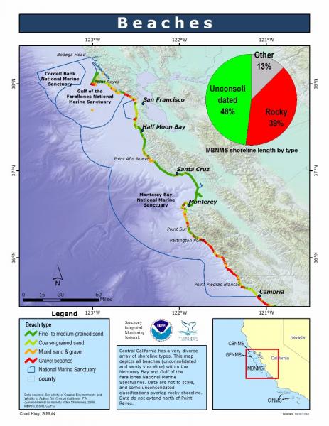
[View Larger]
Projects
Beach Watch
Beach Watch is a long-term, beach-monitoring project. Beaches surveyed stretch from Bodega Head in Sonoma County down to Año Nuevo in San Mateo County. Volunteers survey a designated beach segment counting, identifying, and photo-documenting live and dead birds and marine mammals and human activity on- and immediately offshore.LiMPETS sandy beach monitoring
This page describes the monitoring program implemented by LiMPETS (Long-term Monitoring Program and Experiential Training for Students) in sandy beach habitats.usSEABED: A USGS Pacific Coast Offshore Surficial Sediment Data and Mapping Project
The USGS will soon publish its first release of Pacific coast data from the usSEABED database, a map-based compilation of offshore surficial sediment data.Links
California Coastal Commission - 1995 ReCAP Pilot Project, Monterey Bay Region: Coastal Hazards
This chapter summarizes ReCAP's investigation of shoreline hazard response -- protection of upland development by armoring, the permitting associated with existing armoring, the impacts from armoring, the policies which address shoreline protection, and the likely changes which will happen to the shoreline in the future assuming existing trends and policies continue.http://www.coastal.ca.gov/recap/chap3.html
California Coastal Commission - Waves, Wetlands, and Watersheds Activity Guide
This classroom and community activity guide addresses issues such as endangered species, marine debris, coastal geology, water use, and much more. It is carefully aligned to the California State Science Content Standards for grades 3 through 8, and includes "Community Action" lessons adaptable for all ages up to and beyond grade 12. Available for free.http://www.coastal.ca.gov/publiced/pendx.html
California Geological Survey - An index to online geologic field trips, including coastal Central California
The California Geotour is an interactive index of Web pages of geologic field trip guides and related Web sites compiled by the California Geological Survey (CGS) for the benefit of all who have wondered about California's geologic features.http://www.conservation.ca.gov/cgs/Pages/Geotours.aspx
Coastal Cleanup Day
Learn more about California's largest marine environment volunteer event. Cleanup Day aims to remove debris from our beaches and coasts while educating and building community.http://www.coastal.ca.gov/publiced/ccd/ccd.html
Coastal Water Temperature Guide
A guide to current and past coastal water temperatures for California's central coast.http://www.nodc.noaa.gov/dsdt/cwtg/cpac.html
Farallones Marine Sanctuary Association Coastal Ecosystem Curriculum - Sandy Beaches
This site offers a curriculum centered on beaches along the San Francisco Bay Area peninsula. Sandy beach activities include beach water levels, beach habitat, and a beach profile activity. While this curriculum focuses on the San Francisco area, it can be adapted to almost any beach.http://www.farallones.org/education
Monterey Bay Aquarium - Sandy Shore and Aviary
Beaches and dunes may look barren, but are actually home to many living things. Learn more about these important habitats.http://www.montereybayaquarium.org/efc/sandy.aspx
Monterey Bay Aquarium - Student and Teacher Resources and Activities
The Monterey Bay Aquarium offers teacher and student resources including: species and habitat-specific information, live cams, classroom activities, and interactive online games.http://www.mbayaq.org/lc/
Monterey Bay National Marine Sanctuary - Coastal Dunes
A comprehensive and educational scientific characterization of an important habitat in the Monterey Bay Sanctuary.http://montereybay.noaa.gov/sitechar/coast.html
Monterey Bay National Marine Sanctuary - Sandy Beaches
A comprehensive and educational scientific characterization of an important habitat in the Monterey Bay Sanctuary.http://montereybay.noaa.gov/sitechar/sandy.html
Monterey Bay Sanctuary Citizens Watershed Monitoring Network
The Monterey Bay Sanctuary Citizen Watershed Monitoring Network is a consortium of approximately twenty citizen monitoring groups that monitor the health of the watersheds flowing into the Monterey Bay National Marine Sanctuary. It was established in 1997 and has since provided support, training, and a central forum and database for citizen monitoring programs. The Network also coordinates two annual regional monitoring events, First Flush in the fall and Snapshot Day in the spring.http://www.montereybay.noaa.gov/monitoringnetwork/welcome.html
NOAA Tide Predictions
Obtain tidal predictions computed by CO-OPS (Center for Operational Oceanographic Products and Services) for more than 3000 water level stations.http://co-ops.nos.noaa.gov/tide_predictions.shtml
NOAA's National Marine Sanctuaries LiMPETS Program: Monitoring the Rocky Intertidal
LiMPETS stands for Long-term Monitoring Program & Experiential Training for Students. LiMPETS offers hands on science opportunities for middle school, high school, and other volunteer groups by monitoring the rocky intertidal, sandy shore and offshore areas of the five west coast National Marine Sanctuaries; Olympic Coast, Cordell Bank, Gulf of the Farallones, Monterey Bay and Channel Islands.http://limpets.noaa.gov/
Sandy Beach Monitoring
High school students are helping sanctuaries by monitoring the abundance and distribution of sand crabs at beaches near their schools.http://limpetsmonitoring.org/sandy_beach.php
Santa Cruz Surfrider Foundation - Seawater Testing
The Santa Cruz Chapter of the Surfrider Foundation monitors water quality by testing the presence of bacteria at several locations weekly.http://www.surfridersantacruz.org/
The Bridge - Ocean Sciences Teacher Resource Center
Materials and curricula related to many areas of study in the Monterey Bay. Be sure to check the data tip of the month archives. (Supported by the National Sea Grant Office, the National Oceanographic Partnership Program, and the National Marine Educators Association.)http://www.vims.edu/bridge/
U.S. Environmental Protection Agency - Marine Debris Curriculum
A learning guide entitled "Turning the Tide on Trash" that explains marine debris for grades 3-6 and includes three online units with definitions and activities.http://www.epa.gov/owow/OCPD/Marine/contents.html
USGS - Geology and Coastal Hazards in the Northern Monterey Bay, California, A Field Trip Guidebook
The purpose of this field trip is to explore the relationships between local geology, coastal hazards, and human influences in the northern Monterey Bay, which is a tectonically active, high wave energy coastal environment.http://geopubs.wr.usgs.gov/open-file/of00-438/
USGS - Photo Tour from Año Nuevo to Santa Cruz, California
A digital photographic survey documenting the coastal morphology and stratigraphy between Point Año Nuevo and Santa Cruz, California, with precision-navigated overlapping images.http://pubs.usgs.gov/dds/dds-61/
USGS Pacific Coastal & Marine Science Center
Homepage of USGS Division that conducts multidisciplinary scientific research in the coastal and offshore areas of California, Oregon, Washington, Alaska, Hawaii, and other US Pacific Islands; and in other waterways of the United States.http://walrus.wr.usgs.gov
USGS Western Region Coastal and Marine Geology - Education and Outreach Activities
Online education and outreach activities highlight geologic information helpful for the public, educators, students, scientists, businesses, and government agencies.http://walrus.wr.usgs.gov/pubinfo/