Overview
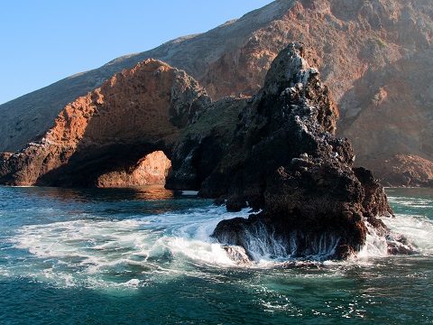
Intertidal zones consist of a variety of coastal habitats periodically covered and uncovered by waves and tides. This transition zone between sea and land is the strip of shore ranging from the uppermost surfaces wetted during high tides to the lowermost areas exposed to air during low tides. Tidal heights within the Channel Islands can be as high as 9.9 feet during full or new moon periods. On surf-swept rocky cliffs, the wave splash can extend water upward of another 17 feet or more.
Intertidal habitat within the sanctuary is composed of approximately 94.5 miles of rocky coastline interspersed with approximately 47 miles of sandy beaches (California Resources Agency, CDFG 2002). Rocky shores support a rich assortment of plants and animals, including numerous green, brown, and red algae, as well as beds of surfgrass. A wide variety of sedentary invertebrates, including barnacles, limpets, and mussels compete for space with the plants in the intertidal zone. Mobile invertebrates, such as snails and crabs, often hide in crevices or under rocks, then emerge to graze on plants or prey on other animals. These intertidal organisms withstand varying degrees of wave shock, dramatic temperature changes, desiccation, and predation by both marine and terrestrial predators.
Fishes in intertidal habitats are limited to tidepools or passing through the intertidal zone at high tide. Seabirds forage in the intertidal at low tide while some roost in aggregations on cliffs just above the shore. Seals and sea lions depend on many of the sanctuary’s intertidal shores for hauling out, especially at San Miguel and Santa Rosa Islands.
Photos
Maps
Projects
California Lost Fishing Gear Recovery Project
The California Lost Fishing Gear Recovery Project was started in July 2005 by the SeaDoc Society (UC Davis Wildlife Health Center). Since its inception, the Project has recovered more than 100 tons of lost fishing gear and other marine debris. The California Lost Fishing Gear Recovery Project proposes to continue to help reduce the potential impact of lost fishing gear on living marine resources and underwater habitat by retrieving lost fishing gear from Channel Islands National Marine Sanctuary (CINMS) and anywhere on the coast where it is a high priority for removal because of demonstrated or potential impacts to marine wildlife and people. 1-888-491-GEAR to report lost, abandoned, and discarded gear.
Channel Islands National Park Rocky Intertidal Community Monitoring
Channel Islands National Park (CHIS) includes the five northern islands off the coast of southern California and the surrounding waters out one nautical mile. There are approximately 176 miles of coastline around the islands; about 80% of which is composed of rock. The diversity and undisturbed nature of the tidepools of this rocky coastline was recognized as a special feature of the islands in the enabling legislation. To conserve these communities unimpaired for future generations, the National Park Service has been monitoring the rocky intertidal communities at the islands since 1982.
Channel Islands Naturalist Corps
Channel Islands Naturalist Corps volunteers are trained by CINMS and CINP to educate the public on board local marine excursion vessels conducting whale watch tours, natural history tours, and island trips. Channel Islands Naturalist Corps volunteers are trained to conduct citizen science on marine mammal field identification and general research. Research objectives of the program include the development of a comprehensive database of incidental marine mammal sightings and reports collected in the Santa Barbara Channel, CINMS and CINP.
Leveraging Drones and Autonomous Boats for Mapping and Monitoring of Shallow-Water Environments in the Channel Islands
Repeat mapping of shallow-water environments is essential for monitoring damage and recovery from episodic events (e.g., major storms), as well as chronic coastal erosion and habitat degradation. Bathymetric data covering the shallowest areas (<5 m water depth) can be challenging to collect, yet is critically needed for benthic habitat mapping. These data are also of interest to NOAA’s Office of Coast Survey (OCS), in areas such as the Channel Islands, where offshore breakers can prohibit vessels from surveying to the navigation area limit lime (NALL). Topobathymetric lidar from conventional (manned) aircraft is often an effective technology, but it can be too expensive for repeat monitoring at high temporal frequencies. Furthermore, the mobilization times can be prohibitive when data are needed immediately after a storm or other disaster.
LiMPETS rocky intertidal monitoring
This page describes the monitoring program implemented by LiMPETS (Long-term Monitoring Program and Experiential Training for Students) in rocky intertidal habitats.Multi-Agency Rocky Intertidal Network
Our coastlines are home to dynamic, highly diverse biological communities that are subject to dramatic changes due to natural phenomena and human activity. MARINe is committed to the long-term study of these rocky intertidal communities across the coast. We invite you to learn about them so that together we can understand how best to protect these valuable resources.
Santa Barbara Coastal Long Term Ecological Research Program (SBC LTER)
The Santa Barbara Coastal Long Term Ecological Research project (SBC LTER ) is an interdisciplinary research and education program housed at the University of California Santa Barbara. SBC LTER was established in April 2000 with the goal of advancing a predictive understanding of how oceanic and terrestrial processes alter material flows to influence the ecology of coastal ecosystems in a changing climate.
Links
MARINe: Multi-Agency Rocky Intertidal Network
Consortium of groups that monitor sites along the entire Pacific Coast of North America, from Alaska to Mexico, and several East Coast sites in Maine and New Hampshirehttps://marine.ucsc.edu/
AlgaeBase
A database of information on terrestrial, marine and freshwater algae, including photos and search functions.http://www.algaebase.org
American Fisheries Society
Strives to advance fisheries and aquatic science and promote the development of fisheries professionals.http://www.fisheries.org
Bilingual MERITO Web Site
The English/Spanish MERITO (Multicultural Education for Resource Issues Threatening Oceans) website provides bilingual information on: MERITO programs, dates of upcoming events, background information on a variety of sanctuary issues, downloadable education materials, and current reports and documents related to MERITO.http://www.montereybay.noaa.gov/educate/merito/welcome.html
Black Oystercatcher monitoring
2011 was the start of the first-ever population assessment of Black Oystercatcher in California.http://ca.audubon.org/birds-0/black-oystercatcher
California Geological Survey - An index to online geologic field trips, including coastal Central California
The California Geotour is an interactive index of Web pages of geologic field trip guides and related Web sites compiled by the California Geological Survey (CGS) for the benefit of all who have wondered about California's geologic features.http://www.conservation.ca.gov/cgs/Pages/Geotours.aspx
Farallones Marine Sanctuary Association Coastal Ecosystem Curriculum – Rocky Shores
Download content on the rocky intertidal of the Gulf of the Farallones National Marine Sanctuary. Curriculum, Powerpoint slideshows, fact sheets, and more. Contact Amy Dean -- Education Manager of the Farallones Marine Sanctuary Association -- PO Box 29386, San Francisco, CA 94129 -- 415-561-6625 x303 -- fax 415-561-6616 -- adean@farallones.orghttp://www.farallones.org
LiMPETS: Long term Monitoring Program and Experiential Training for Students
Middle school, high school and other volunteer groups monitor the rocky intertidal, sandy shore and offshore areas to provide critical data while increasing public awareness.http://limpetsmonitoring.org/
MARINe: Multi-Agency Rocky Intertidal Network
Scientists from Federal, State, and local government agencies, universities, and private and volunteer organizations have formed MARINe to monitor important shoreline resources.https://marine.ucsc.edu/
Monterey Bay Aquarium - Student and Teacher Resources and Activities
The Monterey Bay Aquarium offers teacher and student resources including: species and habitat-specific information, live cams, classroom activities, and interactive online games.http://www.mbayaq.org/lc/
Monterey Bay National Marine Sanctuary - Rocky Shores
A comprehensive and educational scientific characterization of an important habitat in the Monterey Bay National Marine Sanctuary.http://montereybay.noaa.gov/sitechar/rocky.html
NOAA Tide Predictions
Obtain tidal predictions computed by CO-OPS (Center for Operational Oceanographic Products and Services) for more than 3000 water level stations.http://co-ops.nos.noaa.gov/tide_predictions.shtml
NOAA's National Marine Sanctuaries LiMPETS Program: Monitoring the Rocky Intertidal
LiMPETS stands for Long-term Monitoring Program & Experiential Training for Students. LiMPETS offers hands on science opportunities for middle school, high school, and other volunteer groups by monitoring the rocky intertidal, sandy shore and offshore areas of the five west coast National Marine Sanctuaries; Olympic Coast, Cordell Bank, Gulf of the Farallones, Monterey Bay and Channel Islands.http://limpets.noaa.gov/
PISCO: Partnership for the Interdisciplinary Studies of Coastal Oceans
PISCO is a long term, large scale research program aimed at more fully understanding the nearshore environments on the West Coast.http://www.piscoweb.org
Sonoma State University, Department of Biology: Algae, the Forgotten Treasure of Tide Pools
Welcome algae lovers and tide poolers. Celebrate the slimy stuff overlooked by hunters of seastars, urchins, and seaweed! Browse and enjoy this gallery of favorite California green, brown, and red algae.http://www.sonoma.edu/biology/algae/algae.html
University of Rhode Island, Office of Marine Programs: Rocky Shore Classroom Activity
Virtual field trip of Rhode Island's rocky shore.http://omp.gso.uri.edu/doce2.htm
USGS - Geology and Coastal Hazards in the Northern Monterey Bay, California, A Field Trip Guidebook
The purpose of this field trip is to explore the relationships between local geology, coastal hazards, and human influences in the northern Monterey Bay, which is a tectonically active, high wave energy coastal environment.http://geopubs.wr.usgs.gov/open-file/of00-438/
USGS - Photo Tour from Año Nuevo to Santa Cruz, California
A digital photographic survey documenting the coastal morphology and stratigraphy between Point Año Nuevo and Santa Cruz, California, with precision-navigated overlapping images.http://pubs.usgs.gov/dds/dds-61/