Overview
Estuaries represent the confluence of terrestrial, freshwater and marine ecosystems, creating multiple unique habitats that support highly diverse communities and provide crucial links to many nearby ecosystems.
The Greater Farallones National Marine Sanctuary encompasses four major estuaries in Marin and Sonoma Counties: Tomales Bay, Bolinas Lagoon, Estero Americano and Estero de San Antonio. These estuaries provide important marine and nearshore habitats for a diverse array of marine mammals and birds in addition to fishery, plant, algal and benthic resources. They are also important components of the Pacific Flyway, one of the four principal bird migration routes in North America.
Bolinas Lagoon and Tomales Bay are designated “wetlands of significant importance” under the International Convention on Wetlands. The Esteros Americano and de San Antonio are coastal estuaries located on Bodega Bay. Estero Americano drains into Bodega Bay at the Sonoma-Marin County line. South of Estero Americano, Stemple Creek becomes the Estero de San Antonio, also draining into Bodega Bay.
San Francisco Bay, Drakes and Limantour Esteros, and Abbotts Lagoon are all estuaries that although adjacent to the sanctuary, influence sanctuary resources.
Large numbers of marine mammal enthusiasts and bird-watchers spend time along the sanctuary’s coastal estuaries and shorelines observing marine mammals, shorebirds, waders and waterfowl. Some of the most popular places to see seals and other wildlife are within the sanctuary estuaries, such as Tomales Bay and Bolinas Lagoon, as well as within the adjacent Point Reyes National Seashore at Drakes and Limantour Esteros.
Habitats
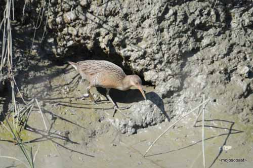
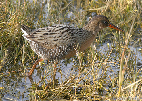
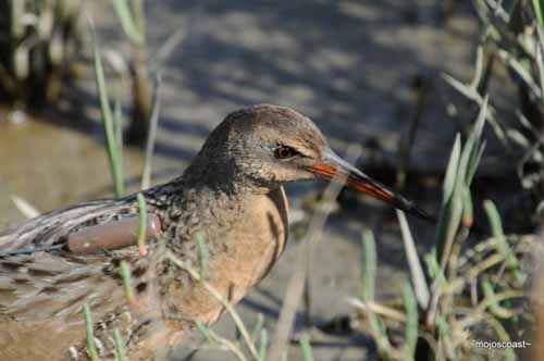
Many different habitat types are found in the esteros, including mudflats, marshes, rocky shore, coastal scrub and grasslands.
Tomales Bay and Bolinas Lagoon sit on top of the San Andreas Fault and are submerged linear estuaries that run along the plate boundaries. Phytoplankton is the primary vegetation in the open-water portion of these habitats, and eelgrass, Zostera spp., is commonly found in tidal and upper subtidal zones of Tomales Bay and the Esteros.
Fish species found in the Esteros include Pacific herring, Clupea pallasii, staghorn sculpin, Leptocottus armatus, and starry flounder, Platichthys stellatus. The endangered tidewater goby, Eucyclogobius newberryi, breeds in the shallow waters of Estero de San Antonio.
Tomales Bay supports seasonal populations of salmon, steelhead, sardine and lingcod, Ophiodon elongatus, which are important local fisheries. Leopard sharks, Triakis semifasciata, breed in Tomales Bay. The shallow bay’s sandy bottom attracts a variety of bottom-dwelling fishes including sole, halibut, skates and rays. White sharks, Carcharodon carcharias, hunt for seals and sea lions that haul out on the sandy beaches and rocks near the mouth of Tomales Bay.
Sea otters, Enhydra lutris, are extremely rare in these waters, however, river otters, Lontra canadensis, are observed occasionally in Tomales Bay headwaters. The rapid disappearance of this habitat, undergoing conversion for agriculture and aquaculture, poses a particular threat to these vulnerable species.
The soft-bottom habitats associated with estuarine environments support large concentrations of burrowing organisms, such as clams, snails, worms and crabs. Benthic invertebrates, in general, have a large effect on community structure in estuaries.
Marine mammals and seabirds living on the Farallon Islands and the mainland coast depend as much on the integrity and productivity of these estuarine waters and adjacent ocean as on the preservation of the shore areas they use for breeding, feeding and hauling out (coming ashore).
Eelgrass plays an important role within the estuaries:
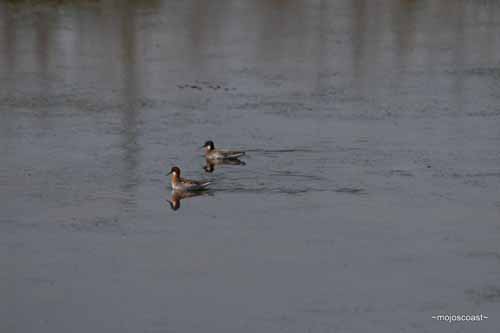
- More than 20,000 shorebirds and seabirds — including loons, grebes, geese, cormorants and duck — winter in Tomales Bay; these migratory birds feed upon the abundant fish and invertebrate species associated with the eelgrass beds.
- Pacific herring use the beds for spawning.
- Eelgrass also supports a diverse invertebrate community, including snails, shrimp, nudibranchs and sea hares.
- The beds also help trap sediments and reduce excess nutrients and pollutants in the water column, and they serve as buffer zones, protecting the coast from erosion.
Threats
The sanctuary’s health is threatened by a number of factors:
Oil Pollution
The threat of an oil spill, such as the 2007 Cosco Busan spill, is a constant reality near the busy shipping lanes in and adjacent to the sanctuary. Oil and other pollutants get into our estuaries and waterways from other sources such as runoff from roads, parking lots and other land areas; improper disposal; and vessel leaks. Once they contaminate the estuary, they affect water and habitat quality and can be very difficult to clean up.
Non-Point Source Pollution
The sanctuary’s coastal waters, particularly the estuarine habitats of Bolinas Lagoon, Tomales Bay, Estero Americano and Estero de San Antonio, are vulnerable to land-based, non-point source pollution from outside the sanctuary. Sources of concern include runoff, agriculture, marinas and boating activities, past mining, and aging and undersized septic systems.
Water quality in offshore areas could be threatened or impacted by large or continuous discharges from shore, spills by vessels, illegal dumping activities or residual contaminants from past dumping activities. Estero Americano, Estero de San Antonio and Tomales Bay are listed as impaired under Section 303(d) of the Clean Water Act because they do not meet water quality standards for specific pollutants, such as coliforms and sediments.
The San Francisco Bay Estuary carries a pollution load generated by the approximately eight million people living in the San Francisco Bay Area as well as effluent from the agricultural Central Valley, via the Sacramento and San Joaquin rivers. Numerous contaminants exiting the San Francisco Bay – including agricultural and livestock waste, wastewater, sewage outfalls, and historic mining and industrial wastes – can be carried into the Greater Farallones via the freshwater outflow from San Francisco Bay (the San Francisco Bay plume).
This plume can extend outward to the Farallon Islands after heavy rainfall. During spring and summer months, the San Francisco Bay plume also carries nutrients into the gulf, which are used by phytoplankton and zooplankton in rapid population growth, helping to stimulate the gulf’s food web.
Urbanization and Watershed Developments
Within the sanctuary there are specific developed and developing areas, such as Bolinas Lagoon and Dillon Beach, where land-use activity is increasing. The watersheds of these areas are also vulnerable to runoff from agriculture, livestock grazing, improperly treated effluent, dumping, water diversion, historic mining and development. These activities are creating additional pressure in the watersheds adjacent to the sanctuary and are affecting its estuarine and nearshore environments.
Aquaculture
Commercial aquaculture has existed in California since the 1850s and in Tomales Bay since the 1890s. In total, about 1,952 acres of bottom lands are leased by individuals from the state for marine aquaculture, and about 80 percent of that area is located in Drakes Estero and Tomales Bay. There are also some limited industrial uses – such as commercial and recreational fishing harbors – in this area.
Introduced Species
Several exotic species discharged in vessel ballast water (and from other sources) have been identified in local bays and estuaries. These estuary waters provide optimal environments for their growth. An invasive species inventory for the sanctuary was completed in 2007 to gain a more complete picture of the species involved and their potential effects. The sanctuary plans additional studies to determine their distribution and abundance. Plans are also underway for a volunteer monitoring program for early detection of newly introduced species.
Wildlife Disturbance
Close vessel passes, low-flying aircraft and clam-digging are known to create behavioral changes in wildlife such as flushing (startle into flight), stampeding (a rush of frightened animals) and abandonment (of nest, eggs or young). Information from monitoring programs helps to identify areas with high disturbance frequency; these areas can then be targeted for increased outreach and enforcement. Of particular concern are seabird colonies at Point Reyes Headlands, Bolinas Lagoon, Drakes Bay, the Farallon Islands, Bird Rock, Tomales Point and Bodega Rock.
MONITORING
The following list includes some of the projects underway in the sanctuary. Please click on the Projects tab at the top of this page for more information.
The sanctuary works with federal and state agencies to monitor its nearshore and estuarine areas for pollutant, oxygen and nutrient levels and algal blooms. The disruption of freshwater influences and increased sedimentation in the four main estuaries are of special concern.
The watersheds of these areas are subject to impacts from agriculture, livestock grazing, improperly treated effluent, dumping, historic mining and development. The sanctuary plans to extend the water quality monitoring program now underway in Tomales Bay to other estuarine areas that are currently not fully monitored, including Bolinas Lagoon, Estero Americano and Estero de San Antonio.
The Bolinas Lagoon Restoration Project
Since the early 19th century, human land uses have altered, and continue to alter, the Bolinas Lagoon’s shoreline and watershed, increasing the rate of sediment delivery and changing the natural processes that shape the lagoon. The result is a human-induced loss of tidal prism; change in composition of plants, animals and habitats; and degradation of water quality.
The Greater Farallones National Marine Sanctuary is partnering with the United States Army Corps of Engineers and Marin County Department of Parks and Open Space to develop a community-supported management plan for the lagoon. The plan will focus on improving water quality, identifying and eradicating introduced species in the Bolinas Lagoon watershed, restoring the diversity of natural habitats and restoring natural sediment transport processes to Bolinas Lagoon by reducing the effects of human-induced changes.
Mussel Watch
The California Department of Fish and Game (CDFG) manages mariculture activities in the sanctuary in state waters, and National Oceanic and Atmospheric Administration (NOAA) Fisheries does so in federal waters. The CDFG’s Mussel Watch program represents one of the longest-term national efforts to track the impacts from non-point source pollution on bioaccumulation in the marine environment.
Originally spearheaded by NOAA, the program was then adopted by the state, which has been a major source of support, although the program has been eroded in recent years by funding cutbacks. Mussel Watch has supplied critical data on the health of coastal, bay, and estuarine waters of the state.
Tomales Bay Vessel Management
Greater Farallones National Marine Sanctuary and the California State Lands Commission (SLC) are co-leaders of a multi-agency effort to identify ways to improve ecosystem protection in Tomales Bay by assessing vessel use and storage. Eleven local, state and federal agencies with jurisdiction over boating, parks, waters, submerged lands, and shore areas of Tomales Bay are working to develop a plan for vessel management. The interagency committee completed a 3 month public review and comment period on its “document for public input” and is currently receiving input from the community through the GFNMS Advisory Council’s working group on Tomales Bay vessel management.
Photos
Maps
Elkhorn Slough Elevation
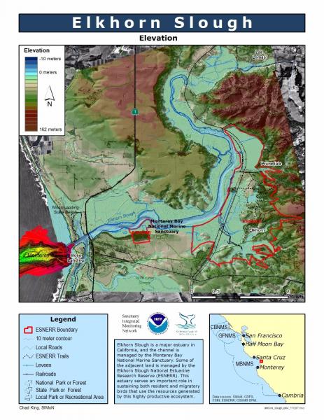
[View Larger]
Elkhorn Slough Land Use
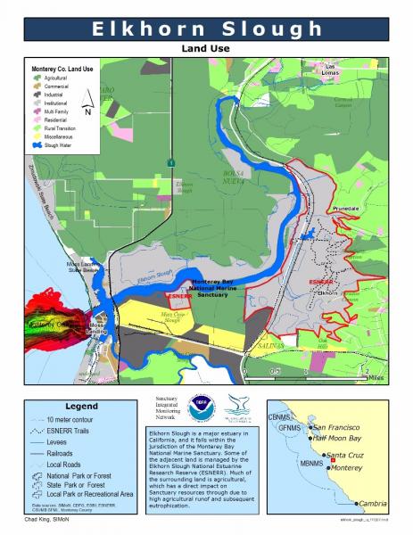
[View Larger]
Elkhorn Slough, Moss Landing and Monterey Canyon
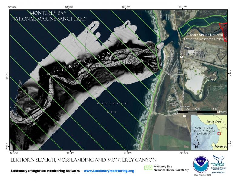
[View Larger]
Projects
Links
AlgaeBase
A database of information on terrestrial, marine and freshwater algae, including photos and search functions.http://www.algaebase.org
Bilingual MERITO Web Site
The English/Spanish MERITO (Multicultural Education for Resource Issues Threatening Oceans) website provides bilingual information on: MERITO programs, dates of upcoming events, background information on a variety of sanctuary issues, downloadable education materials, and current reports and documents related to MERITO.http://www.montereybay.noaa.gov/educate/merito/welcome.html
Birds of Elkhorn Slough
Resources for birdwatchers at Elkhorn Slough include a checklist, bird sightings log, and more information.http://www.elkhornslough.org/sloughlife/birds/
California Coastal Commission - 1995 ReCAP Pilot Project, Monterey Bay Region: Wetlands
This site examines both wetland resources and the institutional framework used to determine how these resources are protected and managed. The historic, current and projected status of wetland morphology (acreage, fragmentation, and habitat), physicochemical processes (hydrology and water quality), and biodiversity are presented.http://www.coastal.ca.gov/recap/chap5.html
California Coastal Commission - Waves, Wetlands, and Watersheds Activity Guide
This classroom and community activity guide addresses issues such as endangered species, marine debris, coastal geology, water use, and much more. It is carefully aligned to the California State Science Content Standards for grades 3 through 8, and includes "Community Action" lessons adaptable for all ages up to and beyond grade 12. Available for free.http://www.coastal.ca.gov/publiced/pendx.html
California Resources Agency - Wetlands Information System
Learn more about California's marshes, estuaries and other wetlands.http://resources.ca.gov/wetlands/
California Resources Agency - Wetlands Information System Education Links
Links provided by the California Resources Agency for reading lists, lesson plans and other information on teaching kids about estuaries.http://ceres.ca.gov/wetlands/ed&research.html
Elkhorn Slough Foundation and the Elkhorn Slough National Estuarine Research Reserve
The Elkhorn Slough is located in the middle of Monterey Bay and provides important habitat for rare plants, animals and many species of birds.http://elkhornslough.org
Elkhorn Slough Tidal Wetland Plan
The purpose of this collaborative planning process is to conserve, enhance, and restore tidal habitats in the Elkhorn Slough watershed by developing strategies to address hydrological management issues.http://elkhornslough.org/tidalwetlandplan.htm
Environmental Protection Agency - National Estuary Program
Website explores these unique environments, including some of the plants and animals that live there. On the site, there are games and activities to teach people how to help protect these natural treasures. Some spanish language resources are available.http://www.epa.gov/OWOW/estuaries
EPA - Estuaries Education
Games and activities designed to teach kids about estuaries.http://www.epa.gov/owow/estuaries/kids/
EPA - National Estuary Program
Learn about the Environmental Protection Agency's estuary protection program.http://www.epa.gov/owow/estuaries/
FOR SEA, Institute of Marine Sciences
Site offers comprehensive and proven hands-on/minds-on K-12 curriculum guides that are available for purchase. Each lesson has student activities preceded by a "Teacher Background" section which contains key concepts, background information, materials needed, teaching hints, extension ideas, and answer keys.http://www.forsea.org
Monterey Bay Aquarium - Student and Teacher Resources and Activities
The Monterey Bay Aquarium offers teacher and student resources including: species and habitat-specific information, live cams, classroom activities, and interactive online games.http://www.mbayaq.org/lc/
National Geographic Xpeditions - Estuaries and Development Lesson
Targeted at the high school level, this website contains a lesson plan that examines a conflict between economic development and the environment and attempts for a sound compromise. Using estuaries as a case study, students are encouraged to consider the interaction between environment conservation and economic demand, and to seek a balance that will protect both the estuarine habitat and economic growth.http://www.nationalgeographic.com/xpeditions/lessons/11/g912/tgestuaries.html
NOAA Photo Library
NOAA's photo library contains incredible shots of an amazing array of animals, technology, scientists, and images of historical treasures. Site also offers search function for images.http://www.photolib.noaa.gov
North Carolina National Estuarine Research Reserve - Information for Teachers and Students
This website has lesson plans based on North Carolina estuaries that can be easily adapted to the Pacific Coast. The site contains a variety of activities and suggestions for integrating estuaries into curriculum or teaching plans. Includes pre-field trip activities that are great for preparation, and after-trip activities for getting the most out of the experience.http://www.ncnerr.org/education/index.html
NOS Education Discovery Kits
Discovery Kits describe the basic scientific principles underlying the applied science and activities of NOAA's National Ocean Service (NOS). Designed for educators and students at the high school level, they are written in easy-to-read, non-technical language, and focus on the themes of oceans, coasts, and charting and navigation.http://oceanservice.noaa.gov/education/kits/welcome.html
Restore America's Estuaries
A nonprofit organization involved in preservation of the nation's network of estuaries by protecting and restoring the lands and waters essential to the richness and diversity of coastal life.http://estuaries.org
The Bridge - Ocean Sciences Teacher Resource Center
Materials and curricula related to many areas of study in the Monterey Bay. Be sure to check the data tip of the month archives. (Supported by the National Sea Grant Office, the National Oceanographic Partnership Program, and the National Marine Educators Association.)http://www.vims.edu/bridge/
USGS - National Wetlands Research Center
Website provides a basis for teachers to develop a tailored, comprehensive study of coastal wetlands. A framework of information and suggestions for activities and demonstrations may be used and revised to accommodate different levels of students.http://www.nwrc.usgs.gov/educ_out.htm