Overview
On global and regional scales, the ocean is changing due to increasing atmospheric carbon dioxide and associated global climate change. In the waters of the Greater Farallones National Marine Sanctuary along California’s north-central coast, regional physical changes include sea level rise, coastal erosion and flooding, and changes in precipitation and land runoff, ocean atmosphere circulation, and ocean water properties. These changes in turn lead to biotic responses within ocean ecosystems, including changes in physiology, phenology, and population connectivity, as well as species range shifts. Regional habitats and ecosystems are thus affected by a combination of physical processes and biological responses.
The Ocean Climate Initiative, spearheaded by Greater Farallones National Marine Sanctuary and run out of the Ocean Climate Center, addresses climate change impacts along the North-central California coast and ocean environment through fostering awareness, advocating solutions, and promoting action to build ecosystem resilience and sustainability.
Climate Change Impacts
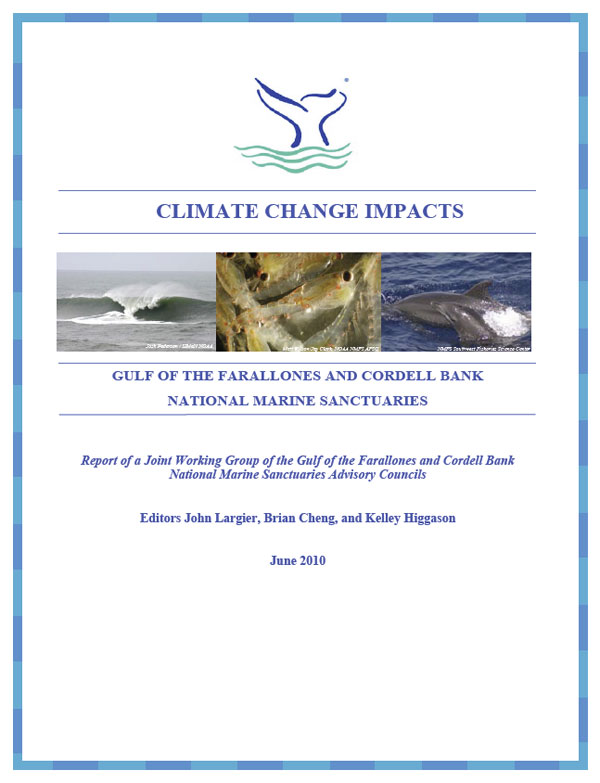
Climate Change Impacts: Greater Farallones and Cordell Bank National Marine Sanctuaries, a report developed by a joint working group of the two sanctuaries Advisory Councils, identifies and synthesizes potential climate change impacts to habitats and biological communities along the north-central California coast.
The report addresses the following key topics:
- Physical effects of climate change, providing the physical basis for regional biotic responses to climate change. Physical effects include sea level rise, coastal erosion and flooding, and changes in precipitation and land runoff, ocean-atmosphere circulation, and ocean water properties.
- Regional biotic responses, addressing the biological implications of climate change in this study region. Biotic responses include changes in physiology, range shifts, changes in phenology, changes in population connectivity, and species-specific responses.
- Habitat response, providing ecosystem-wide snapshots of observed and projected responses to changing climatic conditions specific to each habitat. Habitats include pelagic, benthic, island, sandy beach, rocky intertidal, nearshore subtidal, and estuarine.
- Parallel ecosystem stressors, addressing the implications of multiple stressors acting on an ecosystem and cumulative impacts. Parallel stressors include pollution, invasive species, fishing, harmful algal blooms, and wildlife disturbance.
- Direct impacts on humans are briefly reviewed so as to anticipate responses that may aggravate or mitigate climate change effects on coastal ecosystems in the study region. Direct impacts on humans include public health issues and economic consequences to fisheries, ecotourism and infrastructure.
Key climate change issues that were identified for the north-central California coast include:
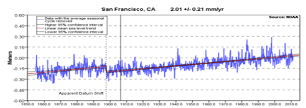
- Observed increase in sea level (100 year record at mouth of San Francisco Bay)
- Expected increase in coastal erosion associated with changes in sea level and storm waves
- Observed decrease in spring runoff of freshwater through San Francisco Bay(decreased Sierra snowpack)
- Observed increase in precipitation variability (drier dry years, wetter wet years)
- Observed increase in surface ocean temperature offshore of the continental shelf (50 year record)
- Observed increase in winds driving coastal upwelling of nutrient-rich waters and associated observed decrease in surface ocean temperature over the continental shelf (30 year record)
- Observed increase in extreme weather events (winds, waves, storms)
- Expected decrease in seawater pH, due to uptake of CO2 by the ocean
- Observed northward shift of key species (including Humboldt squid, volcano barnacle, gray whales, bottlenose dolphins)
- Possible shift in dominant phytoplankton (from diatom to dinoflagellate blooms)
- Potential for effects of climate change to be compounded by parallel environmental changes associated with local human activities
Initiatives and Programs
Climate Smart Conservation Project
The Greater Farallones National Marine Sanctuary Climate Smart Conservation Project is an effort to integrate adaptation planning, as well as monitoring, mitigation, and climate change education, into sanctuary management. Staff has developed a Green Operations (mitigation) plan, and is in the process of developing an Indicators Monitoring Inventory and Plan and a Climate Change Education Plan for the sanctuary. The next phase of the Climate Smart Conservation Project is to develop a stakeholder-led adaptation action plan to respond to and manage for the impacts of climate change to sanctuary resources, including sea level rise. These plans and documents combined will form the Sanctuary’s Climate-Smart Conservation Plan.
Our Coast – Our Future
Our Coast Our Future (OCOF) is a collaborative, user-driven project focused on providing San Francisco Bay Area coastal resource and land use managers and planners locally relevant, online maps and tools to help understand, visualize, and anticipate vulnerabilities to sea level rise and storms within San Francisco Bay and on the outer coast from Half Moon Bay to Bodega Bay.
Bay Area Ecosystems Climate Change Consortium (BAECCC)
Greater Farallones participates as a founding member in the Bay Area Ecosystems Climate Change Consortium (BAECCC), which works to identify and address climate change impacts on local ecosystems by using science to inform adaptive management for long-term ecological and economic benefits.
San Francisco Bay Area Sentinel Site Cooperative
The NOAA Sentinel Site Program provides a place-based, issue-driven approach to ask and answer questions of local, regional, and national significance that affect both NOAA Trust Resources and the surrounding communities, and that will leverage existing assets, programs, and resources. The San Francisco Bay Area Sentinel Site Cooperative combines and enhances current NOAA and partner efforts on projects and programs addressing sea level rise and storms, within San Francisco Bay and on the outer coast from Año Nuevo to Bodega Bay.
California King Tides Initiative
The California King Tides Initiative seeks to engage citizens to photograph king tides, or the highest winter tides, along the entire California coast, including bay areas, in order to raise awareness about the impacts of flooding events and potential impacts of future sea-level rise. In addition, the campaign seeks to create a rich and diverse archive of easily accessible photographs that can be used to inspire action to reduce coastal hazards and impacts from sea-level rise. The California King Tides Initiative was launched in the winter of 2010/2011 by a partnership of state agencies and non-profit organizations.
Ocean Climate Indicators
As part of the Ocean Climate Indicators Project, Dr. Benét Duncan worked with over 50 regional research scientists and resource managers to develop a set of linked physical and biological climate change indicators for the North-central California coast and ocean, extending from Bodega Head to Año Nuevo. Climate change indicators are measurements that provide important information about the status and trends of climate change impacts within a region.
Ocean Climate Summits
The Ocean Climate Initiative has held three Ocean Climate Summits for Bay Area coastal managers, educators, and researchers to connect information, resources, and people across disciplines to collaboratively sustain North-central coast and ocean ecosystem health through fostering awareness, promoting action, and advocating climate smart conservation.
Climate Change Impacts Report
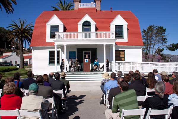
“Climate Change Impacts: Greater Farallones and Cordell Bank National Marine Sanctuaries” was released to the public at California Academy of Sciences Planetarium on June 3, 2010. Authored by a working group of local experts representing 16 agencies, organizations, and academic institutions, the report provides a foundation of information for climate change action plans that will be developed for these sanctuaries. Existing observations and science-based expectations were used to identify an extensive suite of potential climate change impacts to habitats, plants, and animals within the San Francisco Bay Area’s unique ocean and coastal zones.
Photos
Maps
Projects
Are the Waters Along the Central California Coast and Monterey Bay Getting Colder?
There are indications that waters along the California coast are getting colder. Here we briefly examine three questions related to this change. First, how evident is this cooling along the central California coast and in Monterey Bay? Second, when did the change to cooler conditions occur locally? And third, why is it happening?Impacts associated with the recent range shift of the aeolid nudibranch Phidiana hiltoni (Mollusca, Opisthobranchia) in California
The feeding habits of the aeolid nudibranch Phidiana hiltoni were investigated. Implications for the potential impact to species not used to the increased density of this predator are presented.Ocean observing in the Monterey Bay National Marine Sanctuary: CalCOFI and the MBARI time series
This report introduces the CalCOFI and the MBARI programs as they relate to each other and oceanography within the MBNMS. A report (see below) includes a brief review of MBNMS oceanography with summary graphs, and also provide introductory links to the extensive websites and detailed research papers of both programs.Saildrone West Coast Ecosystem Survey
Saildrone provides high-resolution ocean data via a fleet of unmanned surface vehicles (USVs) to NOAA, the Department of Defense, and other US agencies. Saildrone’s USVs are wind-powered vehicles capable of long duration ocean missions (up to 12 months) and carry a sophisticated solar-powered sensor package that streams real-time data to cost-efficiently augment ship-based methods. Saildrone USVs are 23 feet long and 20 feet high, can be launched from any dock, and travel at an average speed of 3-5 knots. The USVs weigh 1200 lbs and have a 7 ft draft.
Links
Global Ocean Acidification Observing Network
The Global Ocean Acidification Observing Network (GOA-ON) is a collaborative international approach to document the status and progress of ocean acidification in open-ocean, coastal, and estuarine environments, to understand the drivers and impacts of ocean acidification on marine ecosystems, and to provide spatially and temporally resolved biogeochemical data necessary to optimize modeling for ocean acidification.http://www.goa-on.org
Sanctuaries and Climate Change
Climate change is happening and human activities are contributing to and accelerating it. Climate change has consequences for people, the planet, and the ocean, including national marine sanctuaries. In general, the sites in the National Marine Sanctuary System will experience the same types of climate change impacts that will be felt in the broader marine and coastal environments, including changes in water temperatures and oceanic circulation, rising sea levels, increasing ocean acidification, changes in precipitation and storms, and their associated effects.http://sanctuaries.noaa.gov/management/climate/welcome.html