Overview
The nearshore zone extends from the surf out to waters that are approximately 30 meters (100 feet) deep. Along the coast of the Monterey Bay National Marine Sanctuary, nearly 80 percent of the nearshore seafloor is covered with soft sediments, such as sand and mud. At a casual glance the sandy seafloor looks barren of life, but with a closer view we see that many organisms make homes either on (i.e., epifaunal) or in (i.e., infaunal) the sediments.
Waves and currents interact with the sandy seafloor in this relatively shallow zone, creating sand waves and ripples and organizing sediment particles into different group sizes.
The composition of the benthic invertebrate communities living in these sediments has been studied extensively in Monterey Bay. Two communities are organized along a gradient of wave-induced substrate motion:
- The crustacean zone: this shallower zone, characterized by strong water motion and sandy sediments, is occupied by small, mobile, deposit-feeding crustaceans. Few animals live in permanent tubes or burrows here.
- The polychaete zone: characterized by more stable, fine sand with a significant amount of mud, this deeper zone is dominated by polychaete worms living in relatively permanent tubes and burrows. Many other relatively sessile and suspension-feeding groups (e.g., brittle stars, clams, tube anemones, sea pens) are common here.
The width and depth limits of these two zones vary, depending on the strength of wave activity. For example, the crustacean zone extends into deeper waters at times or locations where wave activity is greatest. Off a high-energy beach in Monterey Bay, the transition between the two faunal zones occurred at a depth of 14 meters. The polychaete zone is generally well developed in water depths of 20 meters or more in the sanctuary.
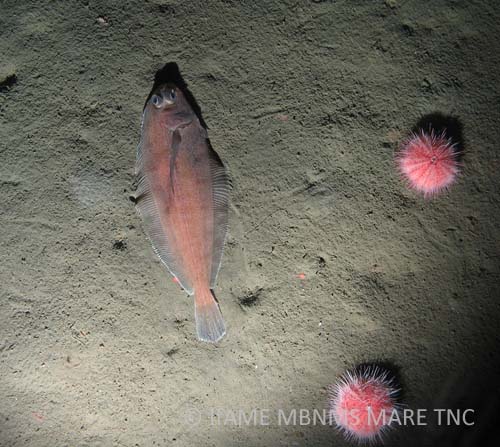
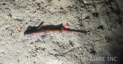
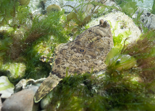
Benthic fishes are less abundant in the crustacean zone than the polychaete zone. Fish diversity on the sandy seafloor is relatively low compared to adjacent reefs, but some of the most abundant species are important forage for large predatory fishes, seabirds and marine mammals. In the sanctuary, representative species in this habitat are juvenile lingcod, white croaker, plainfin midshipman, staghorn sculpin, sand sole, English sole, speckled sand dab and curlfin sole.
The most common natural disturbance in the sandy seafloor habitat is from wave action. Other disturbances are biotic – such as from the digging activities of feeding southern sea otters, Enhydra lutris.
Human-induced disturbances, such as dredging, disposal of dredge material and bottom-tending fishing gear, have been shown to affect the physical structure of the sandy seafloor and subsequently alter the associated biological communities. However, the long-term impacts of many human activities on the sandy seafloor habitat and community are not well understood.
Monitoring
Seafloor Mapping
Mapping the seafloor is an ongoing research priority for the sanctuary. In 2004, scientists from the National Oceanic and Atmospheric Administration (NOAA) and the United States Geological Survey (USGS) used side scan sonar and underwater video technology to map the seafloor in previously unexplored areas and to ground truth existing habitat maps. In addition, researchers were able to characterize benthic macroinvertebrates and fish assemblages associated with different habitat types on the continental shelf. For example, sand-wave habitats were often occupied by sand dabs and often contained schools of juvenile rockfishes, while sediment-ripple habitats were commonly occupied by white brittle stars buried within the sediment.
Ecological Effects of the Moss Landing Thermal Discharge
Researchers from Moss Landing Marine Laboratories evaluated the ecosystem impacts of the Moss Landing Power Plant’s thermal discharge into the sanctuary. The benthic community inhabiting subtidal sand bottom at one, four and six meters was sampled at the plume and at adjacent control sites. No impact on the shallow sandy seafloor of the thermal plume was detected. This study was the first to complete a baseline characterization of sandy seafloor community structure at this shallow depth in central California.
Distribution and Behavior of Sea Otters Relative to the Moss Landing Thermal Discharge Plume
Southern sea otters, Enhydra lutris nereis, have been observed in the thermal plume generated by the Moss Landing Power Plant. The plume is located over the shallow sandy bottom seaward of the entrance to Moss Landing Harbor. This study, completed by a researcher with UC Santa Cruz, found that sea otters are using the area within and immediately surrounding the thermal plume in a non-random fashion; however, the cause of this pattern could not be determined.
Sea otter behavior, and in particular feeding behavior, was generally similar between plume and non-plume areas. Plume foragers had a slightly higher frequency of occurrence of prey types associated with hard substrates, such as mussels and Cancer crab species, while non-plume foragers fed more commonly on soft-bottom species, including clams and fat innkeeper worms.
Identification of Critical Inshore Spawning Grounds for Market Squid
The market squid, Loligo opalescens, supports the largest commercial marine fishery in California, both in terms of quantity landed and dollars paid ex-vessel. This monitoring project, completed by researchers with the Marine Biological Laboratory and Woods Hole Oceanographic Institution, used acoustic sampling technology to find and measure the areas of greatest concentration of the market squid’s benthic egg masses. This method, after further refinement, may allow quantification of the squid’s annual reproductive output in Monterey Bay and identification of critical spawning habitat for this species.
Southwest Ocean Outfall Regional Monitoring Program
The City and County of San Francisco own and operate a pollution control plant that discharges treated municipal wastewater and storm water into the Pacific Ocean about six kilometers (3.75 miles) offshore of Ocean Beach. Approximately 50 stations are sampled annually for sediment quality and benthic infaunal community analysis. Ten of these sampling stations fall in the sanctuary.
No change in sediment grain size has been detected at the outfall. Benthic infaunal community composition represents an assortment of native species common in central California. Sediment grain size appears to be the most important factor structuring infaunal communities. The relative abundance of crustaceans on the shallow sand bars is consistent with the pattern of wave disturbance zonation described in prior studies in Monterey Bay. Wave action along the nearshore (20 meters) route of the cable caused cable strumming and consequent incision of rocky siltstone outcrops. In addition, frayed cable at the 43-meter station probably resulted from seafloor abrasion during high-energy events. Intense trawling activity in the area is another possible cause of damage to the cable.
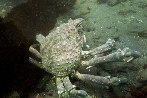
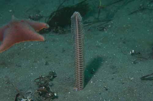
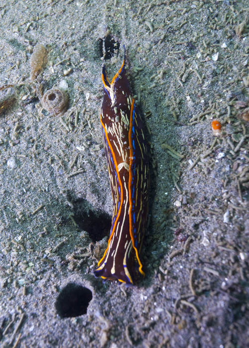
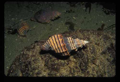
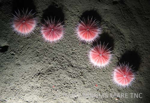
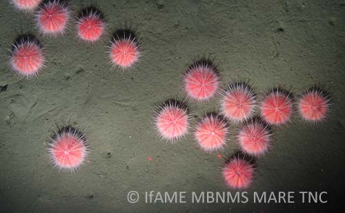
Photos

Maps
Cruise Ship Anchoring Sites
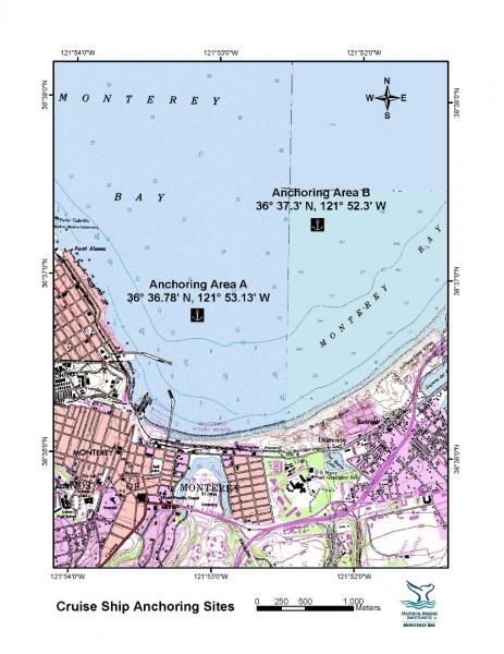
[View Larger]
Projects
Archival of Midwater and Benthic Survey Data at Moss Landing Marine Laboratories
Since the early 1970s, faculty and students in Marine Ecology, Invertebrate Zoology, and Ichthyology courses at Moss Landing Marine Laboratories (MLML) have participated in class cruises aboard several research vessels to survey the fishes and invertebrates in shallow-benthic, deep-benthic and midwater habitats in Monterey Bay.Comparison of discharge plumes from Elkhorn Slough and the Moss Landing Power Plant
This project describes and compares the general flow structure, dynamics and temperature differences between a thermal discharge from an anthropogenic point source (Moss Landing Power Plant) and the natural heat flux between two natural bodies of water, an estuary (Elkhorn Slough) and the open ocean.Delineation of Critical Inshore Spawning Grounds for Commercially Valuable Squid Fisheries on the East and West Coast of the USA
This project proposes to use the best available acoustic sampling technology (hardware, software, and sampling routines) to find and measure the areas of greatest concentration of benthic egg beds of the squids Loligo opalescens.Ecological Effects of the Moss Landing Thermal Discharge
This study was designed to provide a quantitative evaluation of the impacts of the thermal discharge into the Sanctuary from the Moss Landing Power Plant.Effect of the Moss Landing Power Plant thermal discharge plume on the distribution and behavior of sea otters (Enhydra lutris nereis): a preliminary study
Southern sea otters (Enhydra lutris nereis) have occupied various parts of Elkhorn Slough over the past few decades. Recently, a large raft of otters has been noted just within the Moss Landing harbor entrance. In addition, some otters have been observed within and adjacent to the thermal plume generated by the Moss Landing Power Plant. This project studies sea otter behavior in and adjacent to the plume.Fish Surveys at the Moss Landing Power Plant Outfall
This is the first study to characterize the fish assemblage associated with the thermal outfall structure used to discharge heated sea water generated by the Moss Landing Power Plant.Long-term Monitoring of Groundfishes in the Monterey Bay National Marine Sanctuary
Because many populations of fish and invertebrates are declining, we are developing a long-term monitoring plan to assess changes of benthic fishes and macroinvertebrates in the in the Monterey Bay National Marine Sanctuary. Initially we conducted submersible to survey groundfishes in selected deep rocky continental shelf and slope habitats of the sanctuary.Marine Biotechnology Development from Marine-Derived Actinomycetes
Dr. Roger Linington and his students collect sediment samples from throughout the sanctuary, then grow and isolate marine bacteria that may provide new and unique natural products with broad applications in microbiology, biochemistry, chemistry and medicine.Moss Landing Power Plant Post-modernization Thermal Plume Evaluation
A thermal plume evaluation study, which was designed to measure the distribution of heated waters discharged by the modernized Moss Landing Power Plant (MLPP), was conducted in compliance with Central Coast Regional Water Quality Control Board (RWQCB) permit and California Energy Commission (CEC) certification requirements.Multibeam bathymetry mapping of priority habitat areas with the Monterey Bay National Marine Sanctuary
The goal of this project was to provide high-resolution multibeam bathymetry and sonar-derived habitat GIS products for several of the priority mapping areas primarily along the central coast of California from Yankee Point (near Carmel) to the southern MBNMS boundary (near Cambria) at depths <80 m.Northern Central California Coast State Waters Mapping Project (NCCMP)
This project maps the state water seafloor habitats (MHHW out to 3 nm) from Año Nuevo to Bolinas (NCCMP Phase I) using bathymetric LIDAR and multibeam echo sounders (MBES) to obtain both bathymetry data and acoustic backscatter and reflectance imagery.Seafloor Mapping in Monterey Bay, Cordell Bank, and Gulf of the Farallones National Marine Sanctuaries
National Oceanic and Atmospheric Administration and U.S. Geological Survey scientists mapped and characterized seafloor areas on the continental shelf in three west coast National Marine Sanctuaries using side-scan sonar and underwater video technology.Southwest Ocean Outfall Regional Monitoring Program
The City and County of San Francisco owns and operates the Oceanside Water Pollution Control Plant that collects, treats to secondary standards, and then discharges municipal wastewater and storm water into the Pacific Ocean approximately 3.75 miles offshore of Ocean Beach.usSEABED: A USGS Pacific Coast Offshore Surficial Sediment Data and Mapping Project
The USGS will soon publish its first release of Pacific coast data from the usSEABED database, a map-based compilation of offshore surficial sediment data.Links
MARE: Marine Activities, Resources and Education
MARE is an interdisciplinary science program at the Lawrence Hall of Science (UC Berkeley) offering year-round professional development opportunities, including events that immerse your whole school—faculty, students and families—in the study and celebration of the ocean.http://www.lawrencehallofscience.org/MARE/
MBARI - Current Research Projects
Learn about current research projects conducted by the Monterey Bay Aquarium Research Institute (MBARI).http://www.mbari.org/rd/projects/current_projects.html
Monterey Bay Aquarium - Student and Teacher Resources and Activities
The Monterey Bay Aquarium offers teacher and student resources including: species and habitat-specific information, live cams, classroom activities, and interactive online games.http://www.mbayaq.org/lc/
Monterey Bay National Marine Sanctuary - Shallow Soft Bottom Habitats
A comprehensive and educational scientific characterization of an important habitat in the Monterey Bay Sanctuary.http://montereybay.noaa.gov/sitechar/shallow.html
NOAA Photo Library
NOAA's photo library contains incredible shots of an amazing array of animals, technology, scientists, and images of historical treasures. Site also offers search function for images.http://www.photolib.noaa.gov
The Bridge - Ocean Sciences Teacher Resource Center
Materials and curricula related to many areas of study in the Monterey Bay. Be sure to check the data tip of the month archives. (Supported by the National Sea Grant Office, the National Oceanographic Partnership Program, and the National Marine Educators Association.)http://www.vims.edu/bridge/
The Pacific Shark Research Center (PSRC) at Moss Landing Marine Laboratories
The PSRC at MLML conducts both basic and applied scientific research on the biology of Pacific Ocean chondrichthyans, serves as a resource center for scientific information on sharks to public policy makers, and participates in collaborative research on national and international issues involving shark, ray, and chimaera biology.http://psrc.mlml.calstate.edu/
USGS - Monterey Bay Internet Map Server
Continental Shelf GIS for the Monterey Bay Area - selected data layers for the USGS seafloor for the Monterey Bay National Marine Sanctuary Project from USGS published reports and other sources.http://coastalmap.marine.usgs.gov/ArcIMS/website/usa/westcoast/cencal/montereybay/viewer.htm
USGS Pacific Coastal & Marine Science Center
Homepage of USGS Division that conducts multidisciplinary scientific research in the coastal and offshore areas of California, Oregon, Washington, Alaska, Hawaii, and other US Pacific Islands; and in other waterways of the United States.http://walrus.wr.usgs.gov