Overview
The Monterey Bay National Marine Sanctuary provides habitat for a wealth of biological diversity, outstanding recreational opportunities and spectacular coastal scenery that is renowned on a world scale. Every organism that resides within or moves through the sanctuary depends upon clean water, as do all our commercial and recreational uses.
The sanctuary borders nearly 480 kilometers (300 miles) of California’s coastline and receives runoff from watersheds that cover approximately 18,130 square kilometers (7,000 square miles) and support a variety of land uses. The sanctuary is fortunate to be in an area with relatively few impacts from industrial discharges and large point sources of pollution. However, being adjacent to such a large extent of coastline makes it susceptible to impacts from non-point, urban, rural and agricultural pollution sources.
By the time rainfall or irrigation runoff enters streams, rivers, wetlands, estuaries and ultimately the sanctuary, it may contain high levels of nutrients, sediments or dangerous chemicals that have been picked up during the journey from land to sea. Monitoring has shown that while the sanctuary’s offshore areas are in relatively good condition, near-shore coastal areas, harbors, lagoons, estuaries and tributaries suffer from a number of problems, including elevated levels of nitrates, sediments, persistent pesticides, metals, bacteria, pathogens, detergents and oils.
These contaminants can have a variety of biological impacts, including bioaccumulation, reduced recruitment of anadramous species, algal blooms, mortality due to toxicity, transfer of pathogens to wildlife and humans, and interference with recreational use of the sanctuary.
Monitoring
To improve the water quality conditions in the sanctuary, it is important to understand fully where the pollution comes from, where it is going, what its impacts are and how water quality conditions are changing over time. To help address these issues, a number of ongoing water quality monitoring programs currently operate within the sanctuary and its watersheds. These include, among others:
- The Central Coast Ambient Monitoring Program (CCAMP)
- The Central Coast Long-term Environmental Assessment Network (CCLEAN)
- The Sanctuary Citizen Watershed Monitoring Network
- The Coastal Watershed Council (CWC)
- Central Coast Watershed Studies (CCoWS) group
- The US Geological Survey (USGS)
- The Elkhorn Slough National Estuarine Research Reserve (ESNERR)
- Santa Cruz and Monterey County Departments of Environmental Health
- San Francisco Estuary Institute (SFEI)
- The Granite Canyon Marine Pollution Lab
Together, these programs are gathering the data managers need to target source reduction efforts, assess trends and determine impacts.
The effects of human activities on water quality in Monterey Bay are both widespread and varied in the degree to which they disrupt the ecosystem and /or restrict water use. Monitoring and analysis have revealed high concentrations of nutrients, metals, pathogens, detergents and other contaminants in local creeks and rivers as well as in the numerous urban outfalls that drain into sanctuary waters.
As central coast populations grow, more pressure will be exerted on the sensitive ecosystems of Monterey Bay. Public awareness of these problems and an understanding of land use and management practices related to pollutant levels are important components of a strategy to improve water quality in these ecosystems.
The sanctuary’s Water Quality Protection Program (WQPP) educates the public about water quality issues and facilitates implementation of marine, urban and agricultural management practices to improve water quality. SIMoN has partnered with other monitoring organizations in the region to create an ongoing framework for data integration, regional water quality assessments and evaluation of management practice effectiveness.
Persistent Pesticides
Persistent pesticides are known to concentrate in the fats of wildlife; in high concentrations they can cause disease, lack of reproductive potential or mortality.
Toxic conditions that result from persistent pesticides have been shown to exist in the Pajaro River watershed (Hunt et. al., 1999), Salinas River watershed (Anderson et al., 2003; Hunt et al., 2002) and Santa Maria watersheds (Anderson et al., 2006). Contaminants are eventually transported to the ocean, where they can pose risks to human health and collect in the tissues of marine animals.
Recent studies have found high concentrations of persistent pesticides in mussels and sediments collected at The Hook in Capitola and Laguna Creek (CCLEAN Report, 2005). Concentrations of metals, such as copper and zinc, have been detected over the past few years in runoff from urbanized areas of Monterey that drain directly to the ocean (First Flush Report, 2005).
Sediments
Legacy pesticides such as DDT bind to sediments and have been found concentrated at the coastal confluences with watersheds in our region. Excessive sedimentation can bury the gravel river bottoms where salmonids such as Coho and Steelhead spawn.
Nutrients
High nutrient loadings have been identified in Monterey Bay and may be attributed to nitrate runoff associated with fertilizer use in the area. High nitrate levels can result in harmful algal blooms with impacts to native species.
Pathogens
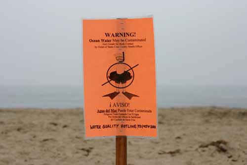
Over the past decade, ocean water has frequently exceeded standards for safe recreation due to bacterial contamination and the potential risk to human health posed by associated pathogens.
The contaminants often derive from runoff that comes directly from urban centers and rural residential areas through storm drains. These drains carry bacteria and detergents in part because of an aging sewer infrastructure.
Photos
Maps
Cruise Ship Anchoring Sites
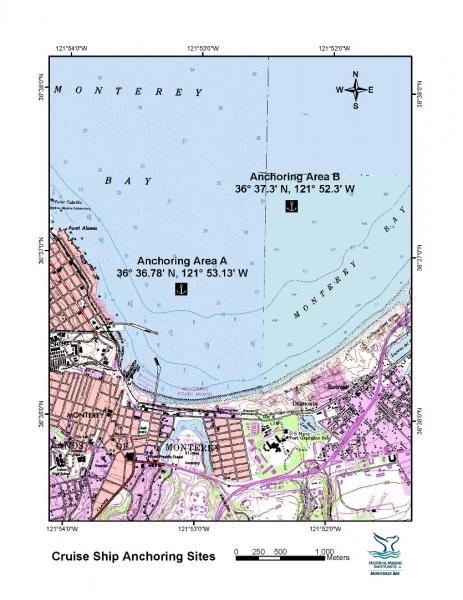
[View Larger]
Projects
Analysis of mussels collected near the Moss Landing Power Plant thermal outfall
The National Oceanic and Atmospheric Administration (NOAA) Mussel Watch Program began in 1986 in order to evaluate pollutant load in U.S. coastal waters by sampling concentrations of contaminants in the tissues of mussels and oysters. In 2006, additional sampling sites were added in the Moss Landing Harbor in order to investigate any differences in contaminant concentrations between mussels near the thermal discharge site of the Moss Landing Power Plant and original Mussel Watch sites. Initial findings show that of the 11 heavy metals sampled, only concentrations of Cadmium (Cd) were found to be higher in mussels near the outfall pipe.California Cooperative Oceanic Fisheries Investigations (CalCOFI)
The California Cooperative Oceanic Fisheries Investigations (CalCOFI) was formed in 1949 to study the ecological aspects of the Pacific sardine population collapse off California. Today, the focus has shifted to the study of the marine environment off the coast of California, the management of its living resources, and monitoring the indicators of El Nino and climate change.
Center for Integrated Marine Technologies: Harmful Algal Blooms
Harmful agal blooms (HABs) are the result of rapid growth of toxin-producing unicellular algae. The toxins (e.g., domoic acid) can poison birds and mammals, close fisheries, and pose serious human health risks. The Center for Integrated Marine Technologies (CIMT) is using a variety of techniques to study this phenomenon.Central Coast Ambient Monitoring Program
The Central Coast Ambient Monitoring Program (CCAMP) is the Central Coast Regional Water Quality Control Board's regionally scaled water quality monitoring and assessment program.Central Coast Long-term Environmental Assessment Network (CCLEAN)
CCLEAN provides the initial nearshore component of the Central Coast Regional Water Quality Control Board's Central Coast Ambient Monitoring Program (CCAMP). This multidisciplinary program includes sampling in watersheds that flow into coastal regions, in estuarine coastal confluences, and at coastal sites.Ecological Effects of the Moss Landing Thermal Discharge
This study was designed to provide a quantitative evaluation of the impacts of the thermal discharge into the Sanctuary from the Moss Landing Power Plant.Effect of the Moss Landing Power Plant thermal discharge plume on the distribution and behavior of sea otters (Enhydra lutris nereis): a preliminary study
Southern sea otters (Enhydra lutris nereis) have occupied various parts of Elkhorn Slough over the past few decades. Recently, a large raft of otters has been noted just within the Moss Landing harbor entrance. In addition, some otters have been observed within and adjacent to the thermal plume generated by the Moss Landing Power Plant. This project studies sea otter behavior in and adjacent to the plume.First Flush Event Monitoring by the Sanctuary Citizen Watershed Monitoring Network
First Flush occurs when the first sheeting rain of the season flushes roadways and impermeable surfaces, carrying months of accumulated contaminants and debris into the ocean.Land/Ocean Biogeochemical Observatory (LOBO)
The LOBO observing system is designed to monitor the flux of nutrients (nitrate, phosphate and inorganic carbon) through the Elkhorn Slough ecosystem. The complete system will include up to eight nodes equipped with nutrient sensors developed at MBARI that are linked to the Internet through a wireless LAN (Local Area Network).Literature Review To Characterize Environmental Contaminants That May Affect The Southern Sea Otter
The objectives of this study are to characterize environmental contaminants present in sea otter habitats that may affect population recovery, synthesize existing data on contaminant concentrations, and map their distribution.Microplastic Concentrations in Surface Seawater in Monterey Bay National Marine Sanctuary
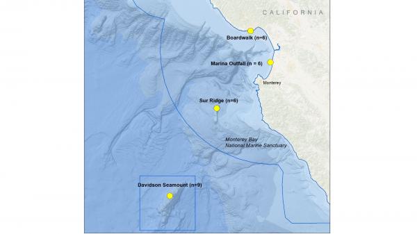
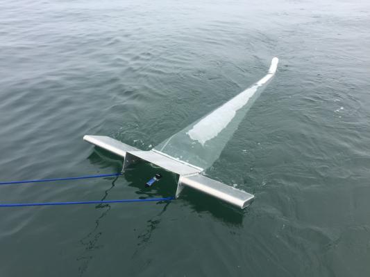
We sampled 27 locations at four distinct locations (2 inshore, 2 offshore) within MBNMS for microplastics. All samples will be analyzed for the presence of microplastics. For a subset of our samples, we used Fourier-transform infrared spectroscopy (FT-IR) to confirm polymer type in an effort to link the debris in our samples to their plastic source.
Monterey Bay Aquarium Incoming Seawater Monitoring
As part of the Monterey Bay Aquarium's ongoing water quality program incoming seawater is monitored with both spot measurements and continuously on a 5minute interval using in situ sensor technology. Both seasonal events, such as upwelling, and periodic events, such as El Niño are visible in the data record.Monterey Bay Aquarium Nearshore Surface Seawater Bacteria Monitoring
The Monterey Bay Aquarium has been monitoring various aspects of near shore seawater quality including levels of bacteria since 1996.
Nearshore water monitoring of oxygen and pH in southern Monterey Bay
A decade-long time series of water quality parameters indicated that the nearshore, shallow subtidal was regularly inundated with cold, low oxygen and low pH waters.NERR System Wide Monitoring Program
The National Estuarine Research Reserve System is a network of state-federal protected areas, representing diverse estuarine ecosystems. Elkhorn Slough NERR has 24 partner reserves that are located on both coasts of the US, as well as the Great Lakes and Puerto Rico. Since 1995 these 25 NERRs carry out consistent system-wide water quality and weather monitoring.Nutrient Sources to Support the Gulf of the Farallones Food Web
The goal of this ongoing project is to determine whether nutrients from San Francisco Bay impact the rich food web of the Gulf of the Farallones in order to assess if anthropogenic changes in the estuary will have management implications for the coastal ecosystem.Ocean Margin Ecosystems Group for Acidification Studies (OMEGAS)
This is a three-year, NSF-funded study on the impacts of acidic ocean waters on two ecologically important species (sea urchins and mussels) in the California Current Large Marine Ecosystem.Santa Cruz County Beach Non-Point Pollution
Santa Cruz County Environmental Health Services (EHS) monitors county beaches and provides water quality information to concerned swimmers to alert them of possible areas that may be contaminated by fecal coliform bacteria.Santa Cruz County Beach Water Quality
Santa Cruz County Environmental Health Service (EHS) has conducted regular testing of freshwater and saltwater swimming areas since 1968.Santa Cruz Ocean Observing Platform (SCOOP)
The primary goals of the Santa Cruz Ocean Observing Platform (SCOOP) are to establish and maintain a long-term dataset of weather and oceanographic measurements at the Santa Cruz Wharf that is accessible to both researchers and the public.Snapshot Day
Snapshot Day (SSD) is a one-day event that utilizes citizen volunteers to collect and analyze water samples from streams that enter the Monterey Bay National Marine Sanctuary (MBNMS). SSD began on the Central Coast on Earth Day 2000 and has become a widely recognized volunteer event in which important water quality information is gathered.Southwest Ocean Outfall Regional Monitoring Program
The City and County of San Francisco owns and operates the Oceanside Water Pollution Control Plant that collects, treats to secondary standards, and then discharges municipal wastewater and storm water into the Pacific Ocean approximately 3.75 miles offshore of Ocean Beach.Volunteer Water Quality in Elkhorn Slough
Elkhorn Slough National Estuarine Research Reserve , the Elkhorn Slough Foundation, and the Monterey County Resources Agency have been supporting a volunteer water monitoring program since 1988. Striking differences between sites and seasons were observed but significant long term changes over time are few.Links
Adopt–A-Watershed
This curriculum is designed for K-12 students and is available for purchase. Topics include: What is a Watershed, Streamside Community, Wade into Watersheds, Water Quality, and Watershed Physics.http://www.adopt-a-watershed.org
Bilingual MERITO Web Site
The English/Spanish MERITO (Multicultural Education for Resource Issues Threatening Oceans) website provides bilingual information on: MERITO programs, dates of upcoming events, background information on a variety of sanctuary issues, downloadable education materials, and current reports and documents related to MERITO.http://www.montereybay.noaa.gov/educate/merito/welcome.html
California Coastal Commission - Waves, Wetlands, and Watersheds Activity Guide
This classroom and community activity guide addresses issues such as endangered species, marine debris, coastal geology, water use, and much more. It is carefully aligned to the California State Science Content Standards for grades 3 through 8, and includes "Community Action" lessons adaptable for all ages up to and beyond grade 12. Available for free.http://www.coastal.ca.gov/publiced/pendx.html
Center for Highly Interactive Computing in Education: hi-ce
A comprehensive Great Lakes based curriculum that is very adaptable to other regions, for middle school grades.http://hice.org/index.html
Central Coast Water Quality Data Synthesis, Assessment and Management (SAM) Project
The SAM Project facilitates region-wide water quality monitoring coordination, data management, and data analysis for addressing the sources, status, and trends of non-point source (NPS) pollution on the Central Coast via technical, scientific, and programmatic activities. Key goals of the project include enhancement of the regional water quality monitoring network and improving access to information used for managing coastal watershed and nearshore marine systems. SAM is a partnership between the Monterey Bay National Marine Sanctuary, the State and Regional Water Quality Control Boards, and the Central Coast Wetlands Group.http://www.ccamp.net/sam/index.php/Main_Page
Central Coast Watershed Studies (CCoWS)
The Central Coast Watershed Studies (CCoWS) team is part of the Watershed Institute, in the Division of Science and Environmental Policy at California State University Monterey Bay. They conduct research on watersheds that feed into the MBNMS.http://ccows.csumb.edu/home/
Coastal Watershed Council
The Coastal Watershed Council is a nonprofit organization committed to the preservation, protection and management of coastal watersheds through establishment of community-based watershed stewardship programs, education and community outreach.http://www.coastal-watershed.org
Elkhorn Slough Water Quality and Weather Monitoring
Learn how two different programs are involvoed in monitoring water quality in the Elkhorn Slough.http://www.elkhornslough.org/research/waterquality_main.htm
First Flush
The Monterey Bay National Marine Sanctuary and the Coastal Watershed Council released a report indicating that storm water is not clean.http://www.publicaffairs.noaa.gov/releases2003/apr03/noaa03r412.html
GLOBE
GLOBE is a worldwide hands-on, primary and secondary school-based education and science program for students and teachers led by a Federal interagency program supported by NASA, NSF, EPA and the U.S. State Department. Students take scientifically valid measurements, report their data through the Internet, analyze data sets, and collaborate with scientists and other GLOBE students around the world.http://www.globe.gov
Monterey Bay Aquarium - Student and Teacher Resources and Activities
The Monterey Bay Aquarium offers teacher and student resources including: species and habitat-specific information, live cams, classroom activities, and interactive online games.http://www.mbayaq.org/lc/
Monterey Bay Sanctuary Citizens Watershed Monitoring Network
The Monterey Bay Sanctuary Citizen Watershed Monitoring Network is a consortium of approximately twenty citizen monitoring groups that monitor the health of the watersheds flowing into the Monterey Bay National Marine Sanctuary. It was established in 1997 and has since provided support, training, and a central forum and database for citizen monitoring programs. The Network also coordinates two annual regional monitoring events, First Flush in the fall and Snapshot Day in the spring.http://www.montereybay.noaa.gov/monitoringnetwork/welcome.html
My Water Quality
Access interactive maps and monitoring data that focus on chemical contaminants and biotoxins in fish and shellfish that may affect the health of human consumers.http://www.waterboards.ca.gov/mywaterquality/
NOS Education Discovery Kits
Discovery Kits describe the basic scientific principles underlying the applied science and activities of NOAA's National Ocean Service (NOS). Designed for educators and students at the high school level, they are written in easy-to-read, non-technical language, and focus on the themes of oceans, coasts, and charting and navigation.http://oceanservice.noaa.gov/education/kits/welcome.html
Overview of Harmful Algal Blooms (HABs)
See how National Centers for Coastal Ocean Science (NCCOS) is acting to respond to the growing threat of harmful algal blooms, which can devastate local economies as well as pose a risk to human health.http://www.cop.noaa.gov/stressors/extremeevents/hab/default.aspx
Project WET
Project Wet is an international, interdisciplinary, water education program for formal and non-formal educators of students ages 5 to 18. Available for purchase only.http://www.projectwet.org/
Santa Cruz Surfrider Foundation - Seawater Testing
The Santa Cruz Chapter of the Surfrider Foundation monitors water quality by testing the presence of bacteria at several locations weekly.http://www.surfridersantacruz.org/
U.S. Environmental Protection Agency - Marine Debris Curriculum
A learning guide entitled "Turning the Tide on Trash" that explains marine debris for grades 3-6 and includes three online units with definitions and activities.http://www.epa.gov/owow/OCPD/Marine/contents.html
U.S. Environmental Protection Agency - Teacher Resources
Need activity ideas for your unit on water quality? Interested in teaching pollution prevention concepts? This site offers curricula, activities and creative ways to teach your students about the environment.http://www.epa.gov/teachers/
